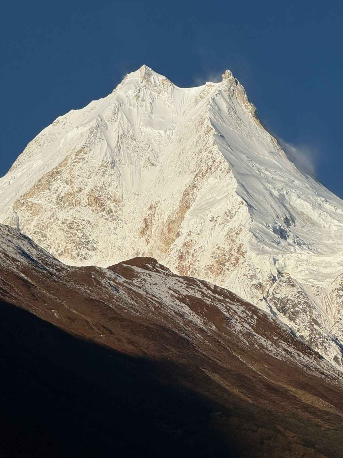
The Manaslu Conservation Area is a 1,663 square kilometer protected region in the Gorkha District of Nepal, established on December 28, 1998, and managed by the National Trust for Nature Conservation (NTNC) under its Manaslu Conservation Area Project (MCAP). It is home to Mount Manaslu, the world’s eighth highest mountain at 8,163 meters, and shelters some of the rarest wildlife and most intact Himalayan cultures still accessible to visitors. If you are planning the Manaslu Circuit Trek, understanding the conservation area you will be walking through changes everything about how you experience it.
This guide pulls together verified data from the NTNC, the Department of National Parks and Wildlife Conservation, and field-level observations from our guides who work in the Budi Gandaki valley every season. It covers the geography, wildlife, plant life, local communities, permit system, trekking routes, conservation history, and everything a visitor needs to understand before entering this area.
What is the Manaslu Conservation Area?
The Manaslu Conservation Area (MCA) is a protected region in northern Gorkha District, Nepal. It sits within the Mansiri Himal range of the greater Himalayas and shares a border with the Tibet Autonomous Region of China to the north. The area was gazetted by the Government of Nepal on December 28, 1998, making it the second conservation area in Nepal to be placed under NTNC management, following the Annapurna Conservation Area.
Unlike a national park, a conservation area in Nepal is designed to allow human communities to live and work within it while their natural resources are managed sustainably. The Manaslu Conservation Area is not a fence around wildlife. It is a living landscape where approximately 9,000 people farm, raise animals, practice Buddhism, and have maintained their traditions for centuries.
The elevation within the conservation area ranges from 1,400 meters in the lower Budi Gandaki valley to 8,163 meters at the summit of Manaslu. This extreme range in elevation creates an equally extreme variety of ecosystems, from subtropical forests at the lowest points to permanent snow and glaciers at the highest, passing through temperate forests, alpine meadows, and high-altitude scrubland along the way.
Geography: three valleys, one mountain
The Manaslu Conservation Area can be divided into three distinct geographic and cultural sub-regions. Each has its own character, its own community, and its own experience for trekkers who pass through.
Nubri Valley (northwest): Samagaun, Lho, and Prok
The Nubri valley covers the northwestern wards of the conservation area, including the high mountain villages of Samagaun, Lho, and Prok. This is Tibetan territory in every cultural and geographic sense. The villages sit between 3,000 and 3,530 meters, surrounded by glaciers, high peaks, and ancient Buddhist monasteries. The people here speak a Tibetan dialect called Nubri and have maintained close cultural ties with Tibet for centuries. Samagaun, the largest village at 3,530 meters, is directly below the south face of Manaslu and serves as the last significant stop before the high section of the Manaslu Circuit Trek begins.
The Lho village at 3,180 meters contains the Ribung Gompa monastery, one of the most photographed structures on the entire circuit because it sits on a flat terrace with Manaslu filling the entire background. Read the detailed Lho Village guide for more on what to see there.
Kutang (middle): Bihi ward
Kutang refers to the middle section of the conservation area, centered on the Bihi ward. This area represents the transition between the lower Gurung-influenced communities and the higher Tibetan Buddhist communities. The Shringi Gompa monastery in Bihi is one of the significant cultural landmarks in the conservation area and is among the monasteries where local lamas actively prohibit harm to wildlife, a practice that has measurably helped animal populations in this zone recover over the decades since NTNC began managing the area.
Tsum Valley (northeast): Chumchet and Chhekampar
The Tsum Valley is the most remote and culturally isolated part of the Manaslu Conservation Area. It covers the northeastern wards of Chumchet and Chhekampar and remained effectively closed to foreign visitors until 2008. The Tsum people are a distinct ethnic group with deep roots in Tibetan Buddhism and a culture that has changed very little over the past several centuries. The major monasteries here, Mu Gompa and Rachen Gompa in Chhekampar, are active religious centers that attract Buddhist pilgrims from across the region. The valley sees a fraction of the trekker numbers that the Manaslu Circuit attracts, which is precisely why those who go there describe it as one of the most meaningful trekking experiences in Nepal. For a complete overview of routes, permits, villages and what to expect, read the Manaslu Tsum Valley Trek complete guide 2026.
The combined route covering both the Manaslu Circuit and Tsum Valley is available as the 19-Day Manaslu Circuit with Tsum Valley Trek, which adds five to seven days through the Tsum valley before rejoining the main circuit trail.
Wildlife of the Manaslu Conservation Area
The conservation area supports one of the most complete mountain ecosystems in Nepal. Recorded species counts from NTNC surveys show 39 mammals, 201 bird species, 3 reptile species, 11 butterfly species, and at least 4 frog species confirmed within MCA boundaries.
Mammals
The most significant mammal in the Manaslu Conservation Area is the snow leopard. The snow leopard is listed as vulnerable on the IUCN Red List with an estimated global wild population of between 4,000 and 7,000 individuals. The Manaslu region, particularly the upper Nubri valley and the rocky terrain around the Larke La, is confirmed snow leopard habitat. Sightings are rare but occur regularly enough that NTNC included it as a primary target species in its 2025 snow leopard population status report.
Blue sheep, locally called bharal, are the primary prey species for snow leopards in the conservation area and are commonly seen on rocky slopes above 4,000 meters, particularly near Samdo and on the approach to Larke La. Their population is considered healthy within the conservation area, which is a direct result of hunting prohibitions enforced by local lamas and the CAMC management structure.
Other notable mammals include the Himalayan tahr, which inhabits steep cliff faces in the 2,500 to 4,000 meter range, the musk deer (listed as vulnerable, hunted historically for musk glands but now protected), the Himalayan serow, the woolly hare, and the Himalayan marmot. The brown bear and the lynx are also present but rarely seen. Common fox, jackal, and Himalayan black bear occupy the lower forest zones.
The red panda, while associated more with the eastern Himalayas, has been reported in the temperate forests of the lower MCA, though verified sightings are infrequent.
Birds
With 201 recorded bird species, the Manaslu Conservation Area is a significant site for birdwatchers. The Himalayan monal, Nepal’s national bird, is present throughout the temperate forest zone and is seen regularly by trekkers in the Namrung to Lho section of the circuit. The blood pheasant and the satyr tragopan are also present in forested sections.
At higher elevations, the Tibetan snowcock, the snow partridge, and the chukor partridge occupy alpine and subalpine grassland habitats. Raptors include the Himalayan griffon vulture, which is frequently seen soaring on thermals above the valley, the golden eagle, and the lammergeier, a massive bearded vulture with a wingspan reaching 2.8 meters that is identified by its diamond-shaped tail in flight.
Lower forest zones along the Budi Gandaki support a rich variety of smaller birds including multiple sunbird species, laughingthrushes, babblers, and woodpeckers. Early morning on the lower trail between Machhakhola and Jagat is among the best birding windows on the entire circuit.
Amphibians and reptiles
Four frog species have been confirmed within the conservation area: Amolops formosus, Nanorana liebigii, Ombrana sikimensis, and Duttaphrynus himalayanus. The presence of Duttaphrynus himalayanus, the Himalayan toad, at elevations above 3,000 meters is particularly notable as it represents one of the highest-altitude amphibian distributions recorded in Nepal. Three reptile species are also recorded, though high-altitude cold limits reptile diversity in this region.
Flora and plant diversity
The Manaslu Conservation Area contains between 1,500 and 2,000 species of flowering plants distributed across 11 forest types that grade from subtropical to nival zones. This plant diversity is a direct result of the extreme elevation range within the conservation area.
Forest zones by elevation
Between 1,400 and 2,000 meters, the lower Budi Gandaki valley supports subtropical mixed forest with sal (Shorea robusta), river alders, figs, and dense bamboo on north-facing slopes. This section of the trail below Jagat passes through some of the most botanically rich forest on the entire route.
From 2,000 to 3,000 meters, temperate broad-leaved forests dominate, with oak, maple, rhododendron, and magnolia. The rhododendron forest between Filim and Deng reaches its peak flowering in late March and April, when the hillsides above the Budi Gandaki turn red and pink. This section also contains significant populations of medicinal plants including herbs used in Tibetan medicine for centuries.
From 3,000 to 4,000 meters, subalpine conifer forests of fir and juniper take over, with the treeline typically occurring between 3,800 and 4,000 meters depending on aspect. Above the treeline, alpine meadows carpeted in dwarf shrubs, sedges, and high-altitude flowering plants extend to approximately 5,000 meters. The open meadows above Samdo in late summer carry gentians, primulas, edelweiss, and Himalayan poppy.
Above 5,000 meters, rock, scree, permanent ice, and glacial moraine dominate. A few specialized plants including high-altitude cushion plants and snow algae represent the limits of vascular plant life in this environment.
The communities of the Manaslu Conservation Area
The approximately 9,000 people living within the Manaslu Conservation Area are not a single group. Three distinct communities occupy different elevations and valleys, each with its own language, traditions, and relationship to the land.
Nubri people
The Nubri people of the upper Budi Gandaki valley (Samagaun, Lho, Prok) are of Tibetan origin and speak the Nubri dialect, which is distinct from standard Tibetan but mutually intelligible with it. Their culture is deeply Buddhist: daily life is structured around monastery schedules, religious festivals, and the agricultural cycle of barley, buckwheat, and potatoes at these high elevations. Trekkers passing through Samagaon will notice mani walls (stone walls carved with Buddhist mantras) lining the trail, prayer flags on every ridge, and chortens at every village entrance. These are not decorative. They are functional elements of a religious landscape that the Nubri people maintain actively.
The Nubri community’s relationship to wildlife conservation is direct and consequential. Local lamas in Samagaon, Lho, and Prok have traditionally prohibited hunting and the disturbance of animals near monasteries and sacred sites. This cultural protection, which predates Nepal’s formal conservation framework by centuries, has contributed significantly to the survival of blue sheep, musk deer, and snow leopard populations in the Nubri valley.
Tsum people
The Tsum people of the Tsum Valley are perhaps the most culturally distinct community within the MCA. The Tsum valley was designated a “hidden valley” in Tibetan Buddhist geography, a place of spiritual sanctuary during times of difficulty. This designation historically discouraged outsiders and allowed the community to develop an extraordinarily intact cultural identity. The valley was only opened to foreign trekkers in 2008, and even now it sees limited visitor numbers.
Tsum culture centers on the Mu Gompa and Rachen Gompa monasteries in the upper valley. These are not heritage sites. They are functioning religious institutions with resident monks and nuns, regular ceremony schedules, and an active role in community governance. The practice of sky burial (jhator), a Tibetan Buddhist funerary tradition, is still observed in the Tsum Valley at specific sites that trekkers are expected to avoid and respect. For key facts about elevation, permits, duration and difficulty, see the Manaslu Tsum Valley Trek fact guide.
Gurung communities
The lower sections of the Manaslu Circuit trail below approximately 2,500 meters pass through territory historically inhabited by Gurung communities, one of Nepal’s most recognized ethnic groups associated with trekking and the Gurkha military tradition. The village of Arughat and communities along the lower Budi Gandaki have Gurung roots, though significant intermarriage and migration over the past century has blended communities in the lower valley considerably.
Monasteries and spiritual heritage
The Manaslu Conservation Area contains a concentration of active Tibetan Buddhist monasteries that is exceptional even by Himalayan standards. These are not ruins or museum pieces. They are living institutions with monks, nuns, students, and ritual cycles that have continued for hundreds of years.
Ribung Gompa, Lho: Situated on a natural terrace at 3,180 meters with an unobstructed view of Manaslu’s south face. The gompa was founded several centuries ago and remains an active monastery. The annual Lhosar (Tibetan New Year) celebrations here attract community members from across the upper valley.
Shringi Gompa, Bihi: Located in the Kutang section, Shringi Gompa is notable for its age, its manuscript collection, and its role in wildlife protection. Lamas here have historically enforced prohibitions on hunting within their spiritual jurisdiction, an informal but effective conservation measure.
Pungyen Gompa, above Samagaun: A two to three hour walk(aoove Samagaun at approximately 4,800 meters, Pungyen Gompa sits on a glacial moraine with glacier views and is one of the most rewarding acclimatization day trips from Samagaun. It is included as an option in the 14-Day Manaslu Circuit Trek itinerary.
Mu Gompa and Rachen Gompa, Tsum Valley: The spiritual heart of the Tsum Valley. Mu Gompa sits at approximately 3,700 meters and is the largest monastery in the Tsum Valley. Rachen Gompa is a nunnery below Mu Gompa that houses the valley’s female religious community. Both monasteries hold festivals on dates determined by the Tibetan lunar calendar, and visiting during these dates offers an experience found nowhere else in Nepal.
NTNC and the conservation management structure
The National Trust for Nature Conservation (NTNC) began working in the Manaslu region in 1997 as the Manaslu Ecotourism Development Project, funded by the Government of Nepal and the Asian Development Bank. When the Government of Nepal formally established the Manaslu Conservation Area in December 1998, it handed over management responsibility to NTNC for a ten-year period. This mandate has since been extended based on the request of local communities and district authorities, recognizing the NTNC’s effectiveness in the region.
The conservation management structure operates through Conservation Area Management Committees (CAMCs), which are locally elected bodies in each ward of the conservation area. CAMCs are responsible for day-to-day resource management decisions, including patrol against poaching, enforcement of firewood regulations, management of trekking permit revenues, and coordination with the MCAP field offices.
MCAP maintains its main field offices in Philim and Sirdibas, with a liaison office in Gorkha. Two tourist check posts and information centers operate at Jagat (the main entry point) and Samagaun (the last major village before the high section). Every trekker entering the conservation area is registered at these checkpoints, which allows NTNC to track visitor numbers and generate revenue for conservation programs from permit fees.
The revenue from the 7,000-plus trekkers who visited MCA in 2018 (a record at that time) is redistributed through the CAMC structure to fund conservation patrols, water supply infrastructure, school improvements, and community health programs. This model, called Integrated Conservation and Development (ICDP), connects the economic benefits of trekking tourism directly to the communities that live within and manage the conservation area.
Permits for the Manaslu Conservation Area: costs and how to get them
Three separate permits are required to trek the standard Manaslu Circuit route. All three must be arranged through a registered Nepali trekking agency. Individual trekkers cannot obtain the restricted area permit independently. This regulation has been in force since the Manaslu region was designated a restricted area, and it remains strictly enforced at checkpoints throughout the route.
For information on finding a reliable agency to process your permits, see our guide to choosing the best Manaslu circuit trek company.
Manaslu Restricted Area Permit (RAP)
The Restricted Area Permit is the most significant of the three permits and the one that defines the Manaslu Circuit as a restricted area trek. It is issued by Nepal’s Department of Immigration in Kathmandu and can only be applied for through a registered trekking agency.
The permit is valid for the first seven days in the restricted area. After seven days, a daily extension fee applies. Current costs as of 2026:
September to November and March to May (peak seasons): USD 100 per person for the first seven days, then USD 15 per additional day.
December to August (off-peak): USD 75 per person for the first seven days, then USD 10 per additional day.
The restricted area requirement also means trekkers must be in a group of minimum two people and must be accompanied by a licensed guide at all times. Solo trekkers can join as a group of two with another solo traveler through their agency.
Manaslu Conservation Area Permit (MCAP)
The MCAP permit is issued by NTNC and funds the conservation and community development programs within the Manaslu Conservation Area. It costs NPR 3,000 per person (approximately USD 22) and is obtained in Kathmandu or at the Gorkha NTNC office. The permit is checked at the Jagat checkpoint and again at Samagaun. Trekkers without a valid MCAP permit are turned back at these checkpoints.
Annapurna Conservation Area Permit (ACAP)
The standard Manaslu Circuit route exits through the Annapurna Conservation Area via the Marsyangdi valley, connecting at Dharapani on the Annapurna Circuit. Because the final days of the trek pass through ACAP territory, the Annapurna Conservation Area Permit is also required. It costs NPR 3,000 per person (approximately USD 22).
Trekkers doing the Manaslu Circuit only without exiting through the Annapurna region (for example, returning to Arughat by vehicle from Dharapani) technically enter ACAP territory only briefly and may handle this permit differently, but for standard circuit completion the ACAP is always included.
For a detailed breakdown of the restricted area status and what it means in practice, see the guide to why the Manaslu Circuit Trek is a restricted area.
Trekking in the Manaslu Conservation Area
The Manaslu Conservation Area contains three main trekking routes and several shorter side trips that together make up one of the most diverse trekking landscapes in Nepal. The primary route, the Manaslu Circuit, circles Mount Manaslu and crosses the Larke La pass at 5,106 meters. Two other routes, the Tsum Valley and the combined Manaslu and Tsum Valley trek, explore the northeastern part of the conservation area.
The Manaslu Circuit Trek
The Manaslu Circuit Trek is the principal route through the conservation area and one of the most complete mountain experiences in Nepal. It starts at Machhakhola (900 m) after an eight to nine hour drive from Kathmandu and follows the Budi Gandaki river upstream through progressively higher, more remote, and more Tibetan-influenced terrain until it reaches Samagaun, Samdo, and then the Larke La pass.
The route passes through every vegetation zone in the conservation area. The lower gorge between Machhakhola and Jagat cuts through subtropical mixed forest. By Deng, the valley opens and the forest becomes temperate. By Namrung, the first Tibetan Buddhist influence becomes visible in the village architecture and the mani walls. By Lho, the landscape is fully alpine, the forest has thinned to scattered conifers and juniper, and Manaslu itself appears for the first time.
The crossing of Larke La (5,106 m) is the physical and psychological high point of the trek. A pre-dawn start from Dharamsala high camp (4,460 m) brings trekkers to the pass in the early morning hours when wind is typically calm. The descent to Bimthang (3,720 m) is steep, sometimes snowy, and magnificent. From Bimthang the trail descends quickly through rhododendron forest to the Annapurna region exit at Dharapani.
For a full guide to the highest section of the route, read the Larke Pass complete guide.
We offer the standard route as both the 13-Day Manaslu Circuit Trek and the 14-Day Manaslu Circuit Trek, with the 14-day version including two full acclimatization days in Samagaun and Samdo. For trekkers interested in a luxury version with upgraded lodges, the Luxury Manaslu Circuit Trek covers the same route with premium accommodation at key villages.
The Tsum Valley Trek
The Tsum Valley branches off the main circuit trail near Machhakhola and follows the Shyar Khola river into a hidden valley that remained closed to foreigners until 2008. The Tsum Valley requires an additional restricted area permit (same cost structure as the Manaslu RAP). Trekking here means smaller groups, fewer lodges, more basic facilities, and an intimacy with Tsum culture that is impossible on the more visited circuit route.
The valley peaks at Mu Gompa (3,700 m) and offers views of Ganesh Himal, Sringi Himal, and the Tibetan plateau. Most trekkers combine Tsum Valley with the Manaslu Circuit as the 19-Day Manaslu Circuit with Tsum Valley Trek, or as the extended 23-Day Tsum Valley and Manaslu Circuit Trek for those who want the most complete experience of the conservation area.
Before booking, these resources are worth reading: the best time to go on the Manaslu Tsum Valley Trek breaks down month-by-month weather and trail conditions, and the Manaslu Tsum Valley Trek packing list covers everything to bring, rent, and expect your operator to provide. Specific questions are answered in the 100 frequently asked questions about the Manaslu Tsum Valley Trek. For a first-hand account, read the 19-Day Manaslu Circuit and Tsum Valley Trek experience. To book with a Kathmandu-based specialist, see the best Tsum Valley Trek company guide.
Manaslu Base Camp Trek
A shorter option, the Manaslu Base Camp Trek goes into the conservation area as far as Manaslu Base Camp (4,800 m) without crossing the Larke La. This is suitable for trekkers with limited time or altitude experience who want to reach the base of the world’s eighth highest mountain without committing to the full circuit crossing.
Key villages on the Manaslu Circuit: what to know at each stop
The Manaslu Conservation Area contains a string of villages that serve as overnight stops on the circuit route. Each has its own character and deserves more than a quick dinner stop.
Jagat (1,410 m): The main entry checkpoint for the restricted area. NTNC’s Jagat checkpost verifies permits here. Read the full Jagat Village guide for what to expect at the first permit checkpoint.
Deng (1,804 m): A transition village where the Budi Gandaki gorge narrows to its most dramatic point. The Deng Village guide covers the deepest gorge section of the route.
Namrung (2,630 m): The first village with strong Tibetan Buddhist character visible in the architecture, with slate-roofed houses and mani walls beginning here. Read about Namrung Village.
Lho (3,180 m): The Ribung Gompa viewpoint above Lho is one of the most photographed spots on the circuit. See the Lho Village complete guide.
Samagaun (3,530 m): The largest high-altitude village and acclimatization base. The Samagaun Village guide covers the acclimatization day options including the walk to Pungyen Gompa and Manaslu Base Camp.
Samdo (3,875 m): The last permanent settlement before the Larke La. The Samdo Village guide covers the Tibetan border viewpoint walk and the second acclimatization day.
Dharamsala (4,460 m): High camp before the pass crossing. One basic lodge. Everything about the Dharamsala overnight stop is covered in the dedicated guide.
Climate zones and what trekkers experience at each elevation
The bio-climatic range of the Manaslu Conservation Area from subtropical to nival means trekkers experience the full spectrum of Himalayan weather within a two-week period.
In the lower valley below 2,000 meters, subtropical temperatures can reach 25 to 30 Celsius in the day during spring and autumn. The Budi Gandaki gorge is humid and can feel surprisingly warm even in October. Light clothing is appropriate here and the trail can be muddy after any rain.
From 2,000 to 3,500 meters, temperatures moderate to 10 to 20 Celsius by day in peak season, dropping to 0 to 5 Celsius at night. This is the most comfortable zone for trekking. Nights in teahouses at Namrung and Lho require a sleeping bag in any season.
Above 3,500 meters, temperatures become alpine. Daytime highs of 5 to 15 Celsius are typical in October, but mornings and evenings drop to minus 5 to minus 10 Celsius. Wind chill above Samagaon in any month can make feels-like temperatures significantly colder.
At the Larke La (5,106 m) during a typical October crossing, temperatures range from minus 10 to minus 20 Celsius with wind. A down jacket, waterproof outer layer, warm hat, and layered gloves are not optional at this altitude.
Best time to trek in the Manaslu Conservation Area
Autumn (September to November) is the prime season for the Manaslu Conservation Area. October in particular offers stable weather, clear visibility to Manaslu and the surrounding Himalayan ranges, fully operational teahouses throughout the circuit, and reliable trail conditions on the Larke La. The Larke La crossing in October is typically snow-free or has only light surface snow on the upper section.
Spring (March to May) is the second-best season. The rhododendron forests between Filim and Deng are flowering in March and April, which makes the lower section of the trail visually spectacular. The Larke La can carry significant snow in March and early April, requiring crampons on some crossings. By May the pass is usually clear.
Winter (December to February) is possible but the Larke La is frequently blocked by snow from December onwards, and temperatures at high camp can drop below minus 20 Celsius. The lower sections of the circuit are walkable in winter but teahouses above Samagaon may be closed. Early December before heavy snowfall is the most viable winter window.
Monsoon season (June to August) brings heavy rain to the lower valley, leeches in the forest sections, and risk of landslides on the road approach from Arughat. The upper valley above Samagaon is in the rain shadow of the Himalayas and remains relatively drier, but the approach is uncomfortable. Some trekkers choose this period for empty trails and significantly lower permit costs.
Getting to the Manaslu Conservation Area
All Manaslu Circuit treks begin from Kathmandu. The road journey to the trailhead at Machhakhola takes eight to nine hours by private jeep or ten to twelve hours by local bus.
The route from Kathmandu goes via Arughat Bazaar in Gorkha District. The road is paved and in reasonable condition from Kathmandu to Arughat. The section from Arughat to Machhakhola (approximately 30 km) is unpaved and rough, particularly after monsoon season when sections can be washed out or damaged. A high-clearance 4WD jeep handles this section far better than a bus.
For a detailed comparison of vehicle options and current road conditions, see the bus vs jeep guide for the Manaslu Circuit.
There is no airport serving the Manaslu region. Helicopter charter directly to Machhakhola or Arughat is technically possible in emergency evacuation situations but is not offered as a tourist service currently. All trekkers begin overland from Kathmandu.
Conservation challenges and climate change
The Manaslu Conservation Area faces serious pressures that the NTNC MCAP management structure is working to address with limited resources.
Glacier retreat is the most visible physical change in the conservation area. Multiple glaciers that feed the Budi Gandaki river, including the Manaslu Glacier and the Larkya Glacier, have retreated significantly since the 1970s. The Larkya Glacier, which the trail crosses on the approach to Dharamsala, is visually smaller each season. Glacial lake outburst floods (GLOFs) are a growing risk as proglacial lakes form on shrinking glaciers.
Deforestation pressure in the lower valley has historically been severe due to dependence on firewood for cooking and heating in a region with no alternative energy source. MCAP programs have installed biogas systems, micro-hydroelectric plants, and improved cooking stoves in some communities, reducing firewood demand. The regeneration of forest in the lower valley since 1998 is visible and documented.
Wildlife poaching, particularly of musk deer for musk glands and snow leopard for skins, was a significant problem before NTNC management. CAMC-managed patrol systems, combined with the traditional religious prohibitions on hunting in the upper valley, have reduced poaching substantially. Snow leopard numbers within the conservation area are believed to be stable or increasing based on track and camera trap data.
Responsible trekking in the Manaslu Conservation Area
The permit system exists partly to regulate visitor numbers and generate funds for conservation, but trekkers also make daily choices on the trail that have direct environmental and community impacts.
Plastic waste: Do not buy single-use water bottles on the Manaslu Circuit. Carry a water filter bottle and use lodge water sources. Single-use plastic has accumulated in rivers and on trails throughout the lower valley over the past decade. Your choices add to or reduce this problem directly.
Firewood: Request lodges that use gas or kerosene for cooking rather than firewood, particularly above 3,000 meters. Every year the treeline in the upper valley is pressured by lodge fuel demand. Paying the slightly higher price for gas-cooked meals rather than wood-cooked meals supports the shift away from forest extraction.
Cultural respect: Ask before photographing people in monasteries or during ceremonies. Remove shoes before entering any gompa. Walk clockwise around mani walls and chortens, not counterclockwise. These are not tourist preferences. They are basic expressions of respect for communities that are sharing their home with you.
Wildlife watching: Snow leopard and other wildlife observations should be reported to your guide, who can report to the nearest CAMC patrol. Do not approach wildlife or encourage guides to pursue animals for photography.
Tipping: Porter and guide wages are set by TAAN, but the tip you leave at the end of the trek is a significant portion of their annual income. Budget USD 10 to 15 per day for your guide tip and USD 5 to 8 per day for your porter tip, paid on the final day in Kathmandu.
Frequently asked questions: Manaslu Conservation Area
When was the Manaslu Conservation Area established?
The Manaslu Conservation Area was established on December 28, 1998, by the Government of Nepal. It is the second conservation area in Nepal managed by the National Trust for Nature Conservation (NTNC) after the Annapurna Conservation Area.
How large is the Manaslu Conservation Area?
The conservation area covers 1,663 square kilometers (642 square miles) in the Gorkha District of Nepal. It ranges in elevation from 1,400 meters in the lower Budi Gandaki valley to 8,163 meters at the summit of Mount Manaslu.
What animals live in the Manaslu Conservation Area?
The conservation area supports 39 mammal species including snow leopard, Himalayan tahr, musk deer, blue sheep, brown bear, lynx, Himalayan serow, woolly hare, and Himalayan marmot. There are 201 recorded bird species including the Himalayan monal, Himalayan griffon, golden eagle, and lammergeier. Three reptile species and four frog species have also been confirmed.
How many permits do I need for the Manaslu Circuit?
Three permits are required: the Manaslu Restricted Area Permit (RAP), the Manaslu Conservation Area Permit (MCAP), and the Annapurna Conservation Area Permit (ACAP). All three must be arranged through a registered Nepali trekking agency. The RAP costs USD 100 per person per week in peak season. MCAP and ACAP cost approximately USD 22 each.
Can I trek the Manaslu Conservation Area independently?
No. The Manaslu region is a restricted area under Nepal law. Every trekker must be accompanied by a licensed guide from a registered trekking agency and must be in a group of at least two people. Solo independent trekking is not permitted. Groups of two or more are required for the restricted area permit.
What is the Manaslu Conservation Area Project (MCAP)?
MCAP is the management body for the conservation area, operated by the National Trust for Nature Conservation (NTNC) under a mandate from the Government of Nepal. NTNC began working in the Manaslu region in 1997 and has been managing the conservation area since its formal establishment in 1998. MCAP implements conservation programs, manages the CAMC network, operates checkposts at Jagat and Samagaun, and reinvests permit revenue into community development and conservation programs.
What is the best trek to do in the Manaslu Conservation Area?
The Manaslu Circuit Trek is the most complete trekking experience in the conservation area, covering all three geographic sub-regions, crossing Larke La at 5,106 meters, and passing through both lower subtropical forest and high-altitude Tibetan Buddhist communities. For those who want the deepest cultural experience, the combined Manaslu Circuit with Tsum Valley Trek adds the isolated Tsum Valley to the route. Both are available with Manaslu Treks and Expedition.
Which communities live inside the Manaslu Conservation Area?
Approximately 9,000 people live within the MCA across three main communities: the Nubri people of the upper Budi Gandaki valley (Samagaun, Lho, Prok), the Tsum people of the northeastern Tsum Valley, and Gurung-influenced communities in the lower valley sections. All three communities are of Tibetan Buddhist heritage in the upper areas and maintain distinct languages, traditions, and cultural practices.
Are there luxury accommodation options in the Manaslu Conservation Area?
Luxury lodge options are limited but growing in the Manaslu region. The Luxury Manaslu Circuit Trek uses upgraded teahouses with private rooms and better facilities at key stops including Samagaun and Bimthang. Full five-star hotel standards are not available on the circuit, but significant comfort upgrades over standard teahouses are possible on the lower and middle sections.
How does the Manaslu Conservation Area compare to Annapurna and Everest regions?
The Manaslu Conservation Area receives significantly fewer visitors than both the Annapurna and Everest regions. This means less crowded trails, a more genuine interaction with local communities, and a stronger sense of remoteness. The trade-off is that teahouse facilities are less developed, particularly above Samagaon, and the permit and restricted area requirements add logistics that the open Annapurna and Everest regions do not have. For a detailed comparison, see the Manaslu Circuit compared to Everest, Annapurna, Langtang and Kanchenjunga.
Ready to trek the Manaslu Conservation Area?
Manaslu Treks and Expedition is a local, TAAN-registered operator specializing only in the Manaslu Circuit and Tsum Valley. No advance payment required. All permits handled in-house.
For trekkers considering a late-autumn visit to the Manaslu Conservation Area, the Manaslu Circuit Trek in November guide covers permit requirements, trail conditions by elevation zone, wildlife sightings, and the unique November festivals you can experience along the route.