Introduction to Manaslu Tsum Valley Trek
The Manaslu Tsum Valley Trek takes you deep into one of Nepal’s most remote corners, where Tibetan Buddhist culture survives exactly as it has for centuries. This trek circles Mount Manaslu, the world’s eighth highest peak at 8,163 meters, and ventures into Tsum Valley, a sacred hidden valley that most Nepalis have never even visited.
What makes this trek different from the packed trails of Everest or Annapurna is simple: hardly anyone comes here. About 6,000 trekkers walk these trails each year compared to over 50,000 heading to Everest Base Camp. The government keeps it that way with restricted area permits and rules requiring licensed guides. You cannot trek here solo, and honestly, you would not want to. The trails are rough, the distances long, and the villages so remote that finding your way without local knowledge would be nearly impossible.
The trek takes 18 to 24 days depending on your route. You cross Larkya La Pass at 5,160 meters, one of the longest and most exposed passes in Nepal. You walk for hours through forests where rhododendrons grow tall as houses. You visit monasteries where monks have been chanting the same prayers for 400 years. You sleep in stone houses in villages where electricity arrived less than a decade ago. If you want a full detailed itinerary, you can check the 23 day Tsum Valley Manaslu Circuit Trek itinerary.
Tsum Valley itself sits tucked against the Tibet border, a dead end valley that you enter and exit through the same narrow gorge. The Tsumba people who live here follow Buddhism so strictly that hunting and killing are completely forbidden. Even their agriculture avoids harming insects. Walking into Tsum Valley feels like stepping back several centuries, which is exactly what draws trekkers who want more than just mountain views. For a shorter route option, you can explore the 19 days Manaslu Circuit Tsum Valley Trek.
In the Manaslu Treks and Expedition, we have guided this route for years. Our guides grew up in villages along the trail. They know which teahouses have the best dal bhat, where altitude sickness hits hardest, and when the clouds usually clear from Manaslu’s summit. This guide comes from actual experience walking these trails through all seasons, dealing with altitude issues, crossing Larkya La in snow, and spending rest days in Samagaon waiting for weather.
The Manaslu Tsum Valley Trek is not easy. Days are long, altitude gains significant, and comforts basic. But if you want to see Nepal before tourism changes it completely, if you want trails where yaks outnumber people, and if you want to understand what real Tibetan Buddhist culture looks like when it is not performing for cameras, this trek delivers all of that.
Why Choose Manaslu Tsum Valley Trek in Nepal
We get asked all the time why someone should choose Manaslu Tsum Valley over the more famous treks. After guiding here for years, the reasons are clear.
You Actually Get Solitude
The crowded trails on popular routes have gotten ridiculous. On Everest Base Camp, you walk in lines of 200 people. Teahouses book out months ahead. Poon Hill at sunrise looks like a photography convention. That does not happen on Manaslu Tsum Valley. You might see 10 to 15 other trekkers total during your entire trip. Some days you walk for hours without seeing anyone except locals. The teahouses rarely fill completely, even in October. This is what trekking in Nepal felt like 30 years ago before it became an industry.
The Culture is Real, Not Performed
Tsum Valley is not set up for tourism. Yes, they have teahouses now, but these are still family homes where trekkers sleep in spare rooms. The monasteries are functioning religious centers, not tourist attractions. Monks actually live, study, and pray there year round. When you visit Mu Gompa or Rachen Gompa, you are entering active religious spaces where ceremonies happen whether tourists show up or not.
The Tsumba people follow Tibetan Buddhism so devoutly that their entire valley operates as a beyul, a sacred sanctuary. They do not hunt. They do not fish. Some families have farmed the same terraced fields for 20 generations. Walking through villages like Chhokang Paro or Nile, you see traditional life continuing exactly as it has for centuries because tourism has barely touched it yet.
Mountain Views From Every Direction
Manaslu dominates your view for days as you circle around it. From the south, the mountain looks massive and close. From Samagaon on the north side, you see the entire north face and the glaciers pouring down from the summit. Cross to the eastern side after Larkya La, and you get completely different perspectives with the Annapurna range appearing behind you.
The pass itself gives you 360 degree views. Glaciers, icefalls, and peaks in every direction. On clear mornings up there, you can see eight different mountains over 7,000 meters. The landscape is so big and raw that photographs never capture the scale.
Basic Teahouses Mean Lower Costs
The infrastructure on Manaslu Tsum Valley is still pretty basic. Do not expect heated rooms, western toilets everywhere, or gourmet menus. Teahouses are simple stone buildings with small rooms, shared bathrooms, and dining halls warmed by wood stoves. Showers are bucket showers. WiFi barely works when it exists at all.
But this keeps costs down significantly. The whole trek costs less than Everest Base Camp because you are not paying for the fancy lodges and elaborate facilities found on commercial routes. You get authentic mountain hospitality instead of tourist hotels.
Challenging Enough to Feel Like an Achievement
This trek is hard work. Larkya La Pass is a serious undertaking. The altitude affects everyone at some point. Days are long, typically 6 to 8 hours of walking. The trails through Tsum Valley gain and lose elevation constantly as they cross side valleys.
But the difficulty is physical, not technical. You do not need climbing skills or special equipment beyond good boots and warm clothes. Anyone with solid fitness and some previous trekking experience can complete it. The challenge comes from sustained effort over weeks, not from dangerous sections or extreme altitude.
Wildlife Actually Exists Here
The Manaslu Conservation Area protects some of Nepal’s best remaining wildlife habitat. We see Himalayan tahr regularly on slopes above the trail. Blue sheep graze on high pastures. The forests are full of birds, including the Himalayan monal pheasant with its iridescent feathers.
Snow leopards live in the high country around Samagaon and Samdo, though seeing one requires incredible luck. Red pandas inhabit the rhododendron forests at middle elevations. The Budhi Gandaki River supports trout and other fish. This is one of the few trekking routes where you still feel like you are walking through wild country, not a managed nature park.
The Trek Combines Two Distinct Adventures
You get two completely different experiences in one trek. The Manaslu Circuit section follows a classic round route: start in lowland villages, climb steadily through different climate zones, cross a high pass, descend into different drainage. It has a clear progression and climax.
Tsum Valley adds a detour into a dead end valley that feels separate from the main trek. You branch off at Philim, climb into this isolated sanctuary, explore for several days, then return to rejoin the circuit. It breaks up the rhythm and adds cultural depth that pure mountain treks lack.
You Support Communities That Really Need Tourism Income
The villages in Tsum Valley and upper Manaslu area are poor by any measure. Agriculture barely produces enough food. Winters are harsh. Traditional trade routes to Tibet closed decades ago. Tourism provides crucial cash income for families to buy what they cannot grow or make themselves.
When you trek here, more of your money goes directly to local people. Teahouses are family owned. Porters and guides come from nearby villages. The permit fees fund conservation and community development projects. Your trek makes a real economic difference in places that have very few other income sources.
Manaslu Tsum Valley Trek Highlights
Walking the entire Manaslu Tsum Valley Trek creates dozens of memorable moments. These are the experiences that stand out most strongly.
Larkya La Pass at sunrise gives you the trek’s most dramatic mountain views. The final climb to 5,160 meters starts around 3 AM in darkness. You reach the pass just as light hits the peaks, turning them gold against deep blue sky. Manaslu, Himlung Himal, Annapurna II, and countless other mountains surround you in every direction.
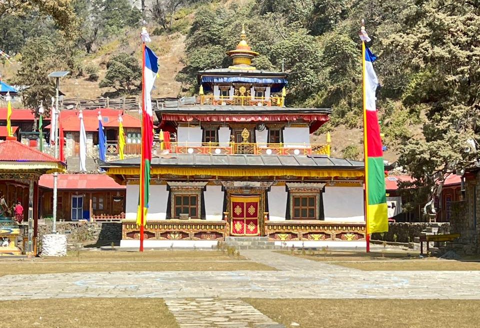
Mu Gompa monastery sits at 3,700 meters near the head of Tsum Valley, the highest permanent settlement in the region. The monastery buildings cling to a barren mountainside with Tibet visible across the border just a few kilometers away. Monks live here year round in conditions that seem impossibly harsh to outsiders.
Rachen Gompa nunnery houses around 80 Buddhist nuns who maintain daily prayer schedules and religious studies. Visiting during morning prayers, you hear chanting echoing through the temple hall while butter lamps flicker in the dim light. The nuns are friendly and curious about visitors, though few speak English.
Nile village and the upper Tsum Valley settlements show traditional Tibetan architecture and lifestyle preserved almost perfectly. Stone houses with flat roofs, prayer flags everywhere, carved wooden windows, Mani walls stretching for hundreds of meters. Agriculture follows centuries old patterns: barley, buckwheat, potatoes grown on terraced fields built by ancestors.
Milarepa’s Cave marks one of Tibet’s most famous yogis and poets who meditated in Tsum Valley during the 11th century. The cave contains ancient religious paintings and carved stones. Buddhist pilgrims still visit to pray and meditate in places where Milarepa achieved enlightenment.
Budhi Gandaki River gorge provides spectacular scenery for the trek’s first several days. The trail clings to cliffsides hundreds of meters above the rushing river. You cross suspension bridges swaying over the water. Waterfalls pour down side valleys. The gorge is so steep and narrow that sunlight only reaches the bottom for a few hours each day.
Samagaon village serves as the main rest and acclimatization stop before Larkya La. The village sits in a wide valley surrounded by massive peaks. Manaslu’s north face dominates the view. The monastery perched above town offers incredible sunset photography when weather cooperates.
Pungyen Gompa and Birendra Lake make excellent acclimatization day hikes from Samagaon. The monastery sits on a ridge with close up glacier views. Birendra Lake, a glacial tarn near Manaslu Base Camp, reflects surrounding peaks on calm mornings.
Traditional Gurung and Tibetan villages along the lower circuit show remarkable cultural diversity. Each ethnic group maintains distinct architecture, dress, language, and customs. Watching daily village life provides insight into mountain communities that survive through subsistence agriculture and seasonal herding.
Rhododendron forests cover the slopes between 2,500 and 3,500 meters. In spring, these forests explode with red, pink, and white blooms. Even outside flowering season, walking through ancient rhododendron trees creates a magical atmosphere with moss covered trunks and filtered sunlight.
Wildlife sightings happen regularly for observant trekkers. Himalayan tahr on rocky slopes, langur monkeys in forests, monal pheasants displaying in clearings, griffin vultures soaring on thermals. The higher you go, the more likely you spot blue sheep and possibly even snow leopard tracks.
Lho monastery offers cultural experiences without the crowds. This active gompa between Namrung and Samagaon contains beautiful religious artwork and provides panoramic mountain views from its hilltop location.
Crossing into Annapurna region after Larkya La demonstrates Nepal’s incredible landscape diversity. Within hours of descending the pass, you transition from barren high altitude desert to lush forests, from Tibetan culture to Gurung villages, from wilderness to the relatively developed Annapurna Circuit trail.
Night skies in the high country are spectacular. At places like Dharamsala before the pass, with no light pollution for dozens of kilometers, the stars appear so bright and numerous that the Milky Way casts shadows.
Teahouse hospitality creates warm memories. Families running lodges go out of their way to make trekkers comfortable despite limited resources. Sitting around wood stoves in dining halls, sharing meals with other trekkers and locals, creates genuine human connections.
Detailed Manaslu Tsum Valley Trek Itinerary
The standard Manaslu Tsum Valley Trek takes 19 to 20 days from Kathmandu and back. Some itineraries extend to 24 days with extra acclimatization or side trips. Here is a realistic day by day breakdown based on our most common route.
Day 1: Drive Kathmandu to Soti Khola (700m) – 7 to 8 hours
The drive follows the Prithvi Highway west toward Pokhara, then branches north into the hills on rougher roads. You pass through Gorkha, the historic capital where Nepal’s unification began. The road deteriorates as you climb into the mountains, eventually reaching Soti Khola, a collection of basic lodges beside the Budhi Gandaki River where the trek officially begins.
Day 2: Trek Soti Khola to Machha Khola (870m) – 6 to 7 hours
The trail follows the Budhi Gandaki upstream through subtropical forest. You cross several suspension bridges and pass through small villages. The path climbs and descends constantly, gaining and losing elevation as it winds around side valleys. Waterfalls cascade down cliffs. The river roars in the gorge below. Machha Khola means “fish river” and serves as the first main overnight stop.
Day 3: Trek Machha Khola to Jagat (1,340m) – 6 to 7 hours
Another day following the river through spectacular gorges. The trail becomes more dramatic with sections carved into cliff faces. You cross the river multiple times on suspension bridges. Villages appear every few hours: Khorlabesi, Tatopani with its hot springs, Dobhan, and finally Jagat where you enter the Manaslu restricted area and permits get checked.
Day 4: Trek Jagat to Philim (1,570m) – 6 to 7 hours
The valley opens up somewhat as you climb. You pass through Salleri and Sirdibas villages. At Ekle Bhatti, the trail splits: one route continues toward the main Manaslu Circuit, the other climbs to Tsum Valley. You take the Tsum Valley trail, crossing the Budhi Gandaki on a suspension bridge and climbing to Philim, a large village where Gurung and Tibetan communities mix.
Day 5: Trek Philim to Chumling (2,385m) – 5 to 6 hours
Today you enter Tsum Valley proper. The trail climbs steadily through forests and crosses several side streams. Lokpa village appears first, then you continue to Chumling, the gateway to upper Tsum Valley. The landscape starts taking on more Tibetan character with Mani walls, chortens, and prayer flags appearing everywhere.
Day 6: Trek Chumling to Chhokang Paro (3,030m) – 5 to 6 hours
The trail continues up the Tsum Valley following the Shiar Khola river. You pass through Rainjam and Gho villages. The valley narrows in places, then opens into cultivated areas around settlements. Chhokang Paro sits in a wide section of the valley surrounded by barley fields and pastures. Mountain views improve dramatically with Ganesh Himal, Buddha Himal, and other peaks visible.
Day 7: Trek Chhokang Paro to Nile (3,360m) – 4 to 5 hours
A shorter day allows gradual acclimatization as you gain altitude. The trail passes Piren Phu, a sacred cave with ancient Buddhist carvings and paintings. Nile village sits higher up the valley with spectacular views of surrounding peaks. The air feels noticeably thinner. Afternoons here are usually spent resting and exploring the village.
Day 8: Trek Nile to Mu Gompa (3,700m) – 3 to 4 hours
The trail climbs to the head of Tsum Valley and the Tibetan border. Mu Gompa monastery appears dramatically situated on a barren mountainside. This is the highest permanent settlement in the valley. You can see Tibet across the border. The monastery is active with monks maintaining daily prayers. The landscape is stark and beautiful, more high altitude desert than forest.
Day 9: Explore Mu Gompa area and return to Rachen Gompa (3,250m) – 5 to 6 hours
Morning exploration around Mu Gompa, visiting the monastery and taking in the mountain views. Then descend back down valley to Rachen Gompa, a large nunnery housing around 80 Buddhist nuns. The descent retraces your route but goes faster downhill. Rachen Gompa welcomes visitors and you can attend evening prayers if timing works out.
Day 10: Trek Rachen Gompa to Chumling (2,385m) – 6 to 7 hours
A long descent back down Tsum Valley, retracing the route to Chumling. The loss of altitude feels dramatic after days spent high. By evening you are back in the warmer, thicker air of mid elevations.
Day 11: Trek Chumling to Deng (1,860m) – 6 to 7 hours
You exit Tsum Valley and rejoin the main Manaslu Circuit trail. The route climbs over a ridge then descends to cross the Budhi Gandaki again. Deng is a small village where the valley narrows significantly with cliffs pressing in from both sides.
Day 12: Trek Deng to Namrung (2,630m) – 6 to 7 hours
The trail climbs steadily through forests and past waterfalls. You cross into areas where Tibetan culture predominates. Namrung village spreads across a hillside with spectacular views of Manaslu’s south face. The architecture shifts to pure Tibetan style with flat roofed stone houses and elaborate wooden carvings.
Day 13: Trek Namrung to Lho (3,180m) – 4 to 5 hours
A shorter day allows acclimatization. The trail climbs gradually through high pastures and stone-walled fields. Lho village appears dramatically with its large monastery perched on a ridge above town. Manaslu dominates the view, looking massive and close from this angle. This is your first clear view of the mountain you will be circling.
Day 14: Trek Lho to Samagaon (3,520m) – 3 to 4 hours
Another short day for altitude adaptation. The trail traverses across the hillside to Samagaon, the largest village in upper Manaslu. This is a rest and acclimatization day location. Samagaon has several lodges, a monastery, and serves as base for exploring side valleys and Manaslu Base Camp.
Day 15: Acclimatization day in Samagaon – Optional hike to Pungyen Gompa or Manaslu Base Camp
Rest day for your body to adjust to altitude. Most trekkers hike to Pungyen Gompa, a monastery with glacier views, or trek toward Manaslu Base Camp and Birendra Lake. These acclimatization hikes take 4 to 6 hours round trip. Rest is crucial before crossing Larkya La.
Day 16: Trek Samagaon to Samdo (3,875m) – 3 to 4 hours
Short trek to Samdo, a seasonal village near the Tibetan border. The landscape becomes more barren and windswept. Samdo was historically a trading post for salt and wool from Tibet. Now it serves mainly as a stop before the pass. The altitude is noticeable here and some trekkers experience headaches or sleep difficulty.
Day 17: Trek Samdo to Dharamsala/Larkya Phedi (4,460m) – 3 to 4 hours
Another short day climbing to Dharamsala, also called Larkya Phedi, the base of the pass. This is essentially a stone shelter at high altitude where you sleep before the pass crossing. The location is exposed and windy. Nights are cold, often well below freezing. You go to bed early because wake up comes around 2 to 3 AM.
Day 18: Cross Larkya La Pass (5,160m) and descend to Bimthang (3,590m) – 8 to 10 hours
The biggest day of the trek. You start climbing in darkness around 3 AM using headlamps. The trail climbs steadily for 3 to 4 hours to the pass. Sunrise hits the mountains as you near the top. The pass itself is a long, exposed ridge with prayer flags and incredible 360 degree views.
The descent from the pass is long and steep, dropping over 1,500 meters to Bimthang. Your knees take a beating. The landscape changes dramatically as you descend, transitioning from barren high altitude to forests and meadows. This is an exhausting but exhilarating day.
Day 19: Trek Bimthang to Tilije (2,300m) – 6 to 7 hours
Continued descent through forests and pastures. You cross into the Annapurna Conservation Area. The trail passes through Karche village and eventually reaches Tilije, where you join the main Annapurna Circuit trail. The change from wilderness to relatively developed trail is noticeable immediately.
Day 20: Trek Tilije to Dharapani (1,963m) and drive to Besisahar/Kathmandu – 3 hours trek + 6 to 8 hours drive
Short morning trek to Dharapani where the road reaches. A jeep or bus then drives back to Besisahar and onward to Kathmandu. The drive is long and dusty but marks the end of the trekking portion. You arrive back in Kathmandu in the evening.
This itinerary represents the standard route. Extensions can add extra acclimatization days, side trips to Manaslu Base Camp, or exploration of additional monasteries in Tsum Valley.
Manaslu Tsum Valley Trek Route and Map Explanation
Understanding the route geography helps make sense of the trek’s progression and challenges.
The trek starts from Soti Khola or Machha Khola in the Budhi Gandaki river valley at around 700 to 900 meters elevation. The valley runs north to south, carved by the river flowing down from Manaslu’s glaciers. For the first several days you simply follow this river upstream through increasingly narrow and dramatic gorges.
At Philim around 1,570 meters, the valley splits. The main Budhi Gandaki continues northwest toward Manaslu. A side valley, the Tsum Valley, branches off to the northeast. A ridge separates these two valleys, and you must choose which to explore first.
Most itineraries take the Tsum Valley detour first. You climb over a small pass and drop into the Tsum Valley, which runs parallel to the main Manaslu route but separated by a high ridge. Tsum Valley is a dead end, blocked at its upper end by high mountains and the Tibetan border. The Tsumba people settled here precisely because of this isolation.
You trek up Tsum Valley from Philim through Chumling, Chhokang Paro, and Nile to Mu Gompa near the valley head at 3,700 meters. Then you retrace your steps back down to Chumling and cross back over to the main Manaslu Circuit route. This detour adds 5 to 6 days and significant extra mileage, but it accesses a region few people ever see.
Back on the main circuit, you continue following the Budhi Gandaki northwest. The valley gains altitude steadily through Deng, Ghap, Namrung, Lho, Shyala, and Samagaon. Each village sits higher than the last. The landscape transitions from subtropical forest at lower elevations through temperate forests to alpine meadows and finally to high altitude desert approaching the pass.
Samagaon at 3,520 meters sits in a wide valley on the northern side of the Manaslu massif. This is the last large village before the pass. From here, the route climbs northwest to Samdo at 3,875 meters, a smaller settlement. Then another climb leads to Dharamsala at 4,460 meters, which is barely even a settlement, just a stone shelter where trekkers sleep before attempting the pass.
Larkya La Pass at 5,160 meters crosses the ridge separating the Budhi Gandaki drainage from the Marsyangdi drainage to the east. This is the trek’s high point and most challenging section. The pass itself is actually a long, gradually rising traverse across a glacial valley, not a sharp summit. Prayer flags mark the highest point.
From the pass, you descend steeply eastward, losing over 1,500 meters to Bimthang at 3,590 meters. This descent is brutal on the knees. Bimthang sits in a beautiful high meadow surrounded by peaks. From here you continue descending through Karche and Gho, eventually reaching Tilije at 2,300 meters where you join the Annapurna Circuit trail.
The final section to Dharapani follows the Annapurna Circuit route downstream along the Dudh Khola river. This section is relatively easy compared to what you have already done. At Dharapani, the road meets the trail and you drive out rather than walking further.
The entire route forms a rough horseshoe shape around Manaslu, with the Tsum Valley detour creating an additional loop to the northeast. Total walking distance is approximately 220 to 240 kilometers depending on exact route and side trips. The elevation profile shows constant ups and downs, though the general trend is steadily upward until the pass, then steeply downward afterward.
Distance and Duration of Manaslu Tsum Valley Trek
The complete Manaslu Tsum Valley Trek covers approximately 220 to 240 kilometers of actual walking distance. This measurement includes the Tsum Valley detour, all village to village distances, and the route over Larkya La Pass. Side trips to places like Mu Gompa or Manaslu Base Camp add extra kilometers on top of this base distance.
Daily walking distances vary considerably. Short days cover only 8 to 10 kilometers when you are gaining significant altitude or allowing acclimatization. Long days can reach 20 kilometers when following valley floors or descending after the pass. Most days fall in the 12 to 16 kilometer range.
Walking time each day typically ranges from 4 to 8 hours excluding breaks. The pass crossing day takes 8 to 10 hours. Acclimatization days involve 0 to 4 hours of optional hiking. Rest days in Samagaon and sometimes Samdo allow your body to adjust without long walks.
The total trek duration depends on your starting point and itinerary variations. From Kathmandu to Kathmandu, including driving days, the trek typically takes:
- Standard itinerary: 19 to 20 days
- With extra acclimatization: 21 to 22 days
- With Manaslu Base Camp side trip: 22 to 24 days
- Fast version skipping some acclimatization: 17 to 18 days
Pure trekking days, excluding driving to and from Kathmandu, total 15 to 18 days. The Tsum Valley portion alone takes 5 to 6 days as a detour from the main circuit. Without the Tsum Valley extension, the basic Manaslu Circuit completes in 12 to 14 days.
Elevation gain and loss totals are significant. From Soti Khola at 700 meters to Larkya La Pass at 5,160 meters represents about 4,460 meters of total ascent, though this is spread over many days with ups and downs along the way. Cumulative elevation gain including all the small climbs and descents reaches approximately 9,000 to 10,000 meters over the course of the trek.
The descent from the pass to Dharapani drops about 3,200 meters over 2 to 3 days. This sustained downhill walking is tough on knees and requires good trekking poles and proper technique.
Comparing to other major Nepal treks, the Manaslu Tsum Valley Trek is longer than Annapurna Base Camp (7 to 10 days) and Langtang Valley (7 to 9 days), roughly equal to the full Annapurna Circuit (18 to 21 days), and slightly longer than Everest Base Camp (12 to 14 days).
The extended duration reflects both the remoteness requiring longer access and the addition of Tsum Valley exploration. You cannot rush this trek. The altitude requires proper acclimatization. The distances are real. Plan for at least 19 days Kathmandu to Kathmandu, and add buffer days if your schedule allows in case weather or altitude issues cause delays.
Manaslu Tsum Valley Trek Difficulty and Who It Is Suitable For
The Manaslu Tsum Valley Trek falls into the moderate to strenuous difficulty category. It is significantly harder than short treks like Poon Hill or Langtang Valley but does not require technical climbing skills like expedition peaks.
Physical Demands
You walk 5 to 8 hours most days carrying a small daypack while porters carry your main luggage. The terrain includes everything from gentle valley trails to steep climbs gaining 800 to 1,000 meters in a day. Stone steps, rocky paths, tree roots, suspension bridges, and occasional snow or ice all appear along the route.
Your cardiovascular system gets worked hard. Days start with gradual climbs that steepen as you gain altitude. Thin air above 3,000 meters makes every climb feel harder. By the time you reach Dharamsala at 4,460 meters, walking uphill requires frequent rest stops even for fit trekkers.
The pass crossing day is genuinely difficult. You climb 700 meters from Dharamsala to the pass in thin air starting before dawn. Then you descend 1,500 meters to Bimthang, taking 8 to 10 hours total. This single day tests your limits more than any other.
Downhill sections punish your knees and ankles. The descent from Larkya La to Bimthang is relentless, losing altitude so fast that your legs shake by the end. Trekking poles become essential equipment, not optional extras.
Altitude Challenges
Maximum altitude of 5,160 meters at Larkya La Pass puts you well into the zone where altitude sickness becomes a real concern. Everyone experiences some effects: reduced appetite, difficulty sleeping, mild headaches. These are normal and expected.
More serious altitude sickness hits maybe 10 to 15 percent of trekkers, usually those who climb too fast or ignore warning symptoms. The itinerary includes acclimatization days specifically to reduce this risk. Following the schedule, staying hydrated, and listening to your body keeps most people safe.
The pass crossing happens at extreme altitude but you do not sleep there. Dharamsala at 4,460 meters is your highest sleeping elevation. This makes a big difference because altitude problems worsen during sleep when breathing slows.
Technical Requirements
Zero technical skills needed. This is pure walking. No ropes, no ice axes, no climbing gear beyond what you carry for warmth and safety. The trail is always visible even if rough in places.
Larkya La Pass can have snow and ice depending on season and conditions. In these situations, guides may provide microspikes or crampons for the pass crossing. Even then, you are walking carefully, not climbing.
Suspension bridges require some nerve if you are afraid of heights. The bridges sway and bounce as you cross. Most are sturdy and safe, but the long ones across deep gorges can be intimidating. You get used to them after crossing a few dozen.
Who Can Do This Trek
This trek suits people who:
- Have previous multi day trekking experience
- Maintain good cardiovascular fitness through regular exercise
- Can walk uphill for several hours without excessive fatigue
- Handle basic accommodation and simple food
- Deal with cold, altitude, and physical discomfort without complaint
- Have 3 to 4 weeks available for the journey
Age is less important than fitness. We guide fit 60 year olds who complete the trek fine. We also see struggling 25 year olds who sit at desks all year and show up unprepared.
Previous altitude experience helps but is not essential if you acclimatize properly. Having been to 4,000 or 5,000 meters before gives you confidence that your body handles altitude okay. But plenty of people complete this as their first high altitude trek.
Who Should Reconsider
This trek challenges people who:
- Have no previous trekking experience beyond day hikes
- Are sedentary with low fitness levels
- Have significant knee or ankle problems
- Need comfort and amenities
- Cannot handle uncertain conditions and basic facilities
- Have less than 3 weeks available
- Have health conditions that worsen with altitude
Serious health issues like heart conditions, severe asthma, or previous altitude sickness problems require medical clearance before attempting this trek. Talk to your doctor honestly about what the trek involves.
Training Recommendations
Proper training makes the trek enjoyable rather than suffer-fest. Start training at least 2 to 3 months before departure. Focus on:
- Cardiovascular endurance: hiking, running, cycling, or swimming 3 to 4 times weekly, gradually building to 2 hour sessions
- Hill training: stairs, treadmill incline, or actual hills with a loaded backpack
- Leg strength: squats, lunges, step ups to build muscles that power uphill walking and control downhill descents
- Back to back days: practice hiking two long days consecutively to simulate trekking without rest days
Mental preparation matters too. Expect discomfort. Expect cold. Expect basic food and lodging. Expect your body to feel tired. If you can accept these realities and focus on the incredible scenery and cultural experiences, the difficulty becomes manageable.
Larkya La Pass Crossing Experience and Altitude
Crossing Larkya La Pass at 5,160 meters is the Manaslu Tsum Valley Trek’s defining challenge and most rewarding moment. This section deserves detailed explanation because how you approach the pass largely determines whether you succeed and enjoy the experience.
Pre Pass Preparation
The climb to Dharamsala the day before puts you at 4,460 meters, gaining about 600 meters from Samdo. This placement lets you sleep as high as reasonable while keeping the pass crossing to a manageable 700 meter climb. You arrive at Dharamsala around midday with the afternoon to rest.
Dharamsala barely qualifies as a settlement. It consists of a stone building with dormitory sleeping and a basic dining room. No private rooms exist. Everyone sleeps in one large room on wooden platforms with sleeping bags. Temperatures drop well below freezing at night.
Dinner happens early, around 5 to 6 PM. You eat carbohydrates, drink lots of tea, and try to sleep by 7 PM. Sleep comes difficult at this altitude. Your breathing feels labored. Some people wake with headaches. This is normal if uncomfortable.
Wake up comes brutally early around 2 to 3 AM. You dress in the dark, eat a small breakfast, fill water bottles with hot water, and start walking by 3 to 3:30 AM. Starting this early means you cross the pass before winds pick up and before afternoon weather potentially deteriorates.
The Climb
The trail from Dharamsala to the pass climbs steadily but never impossibly steep. You gain 700 meters over about 4 to 5 kilometers of switchbacking trail. In darkness, your world shrinks to the small circle of light from your headlamp showing the next few meters of path.
The pace is slow, much slower than you walk at sea level. Every 20 to 30 steps you stop to catch your breath. The air contains maybe 50 percent of the oxygen available at Kathmandu. Your lungs work hard. Your heart pounds. This is normal at extreme altitude.
Cold is intense before sunrise. Temperatures commonly reach minus 10 to minus 15 Celsius. Wind adds to the chill. You wear every warm layer you brought. Down jacket, warm hat, gloves, maybe even a balaclava. You stay warm enough while moving but cool quickly during rest stops.
The trail crosses a glacial valley with ice and snowfields depending on season. This section can be slippery. Guides watch carefully and sometimes rope people together if conditions are dangerous. Microspikes or crampons help with traction on ice.
As dawn approaches, the eastern sky lightens from black to deep blue to pale orange. Mountains emerge from darkness as silhouettes, then details appear as light increases. By the time you near the pass, you can see clearly without headlamps.
Summit and Views
The pass itself is marked by prayer flags strung across the trail and rock cairns built by previous trekkers. The exact highest point is somewhat arbitrary since the pass is actually a long gradual ridge rather than a sharp col.
Views from the top are staggering. Manaslu dominates to the west, its summit pyramid rising above glaciers. Himlung Himal stands to the north near the Tibetan border. Annapurna II shows to the southeast. Cheo Himal, Gang Himal, Kang Guru, and dozens of other peaks fill every direction.
The pass opens into a high glacial valley surrounded by mountains. Icefalls cascade down from hanging glaciers. Moraines stretch across the valley floor. The scale is immense, dwarfing the tiny human figures crossing the pass.
Most groups spend 30 to 45 minutes at the pass taking photos, celebrating, and catching breath before starting the descent. This timing usually puts you at the top around sunrise when light is best for photography.
The Descent
The descent from Larkya La to Bimthang drops 1,570 meters over roughly 12 to 15 kilometers. This takes 4 to 6 hours depending on snow conditions and fitness.
The upper section crosses snowfields and rocky moraines. Footing is tricky. The steep gradient means you must control your descent carefully to avoid sliding or twisting ankles. Trekking poles take enormous strain off your knees.
As you drop below 4,500 meters, vegetation reappears. First just patches of grass and tiny alpine flowers, then low shrubs, eventually forests. The change from barren high altitude desert to green forest happens remarkably fast.
The trail eventually reaches meadows at Bimthang where yaks graze in summer. The settlement has several lodges where you finally stop for the night. By the time you arrive, you have been walking 8 to 10 hours. Every muscle aches. Your knees throb. You are exhausted.
But you made it. You crossed one of the great Himalayan passes. That night’s sleep, despite basic lodge conditions, feels incredible.
Altitude Effects
Nearly everyone experiences some altitude symptoms approaching and crossing the pass. Common effects include:
- Headaches, usually mild, sometimes moderate
- Reduced appetite and slight nausea
- Difficulty sleeping and vivid dreams
- Increased urination
- Shortness of breath with minimal exertion
- Mild dizziness when standing quickly
These symptoms are normal responses to altitude, not signs of serious problems. They typically improve once you descend after crossing the pass.
Serious altitude sickness is rare if you have acclimatized properly. Warning signs include severe headache not relieved by pain medication, vomiting, confusion, loss of coordination, or extreme fatigue. If these appear, immediate descent is required.
The key to safe pass crossing is starting acclimatized. The rest days in Samagaon and slow ascent from there to Dharamsala give your body time to produce extra red blood cells and adjust to thin air. Rushing this schedule greatly increases altitude sickness risk.
Weather Considerations
Weather at the pass is unpredictable. Clear mornings can turn stormy by afternoon. This is why crossing early in the day matters. Get over the pass before weather deteriorates.
In spring and autumn, mornings are usually stable with clearing skies. Clouds and wind typically build after 10 AM. Winter brings extreme cold but often stable weather. Monsoon summer sees frequent afternoon storms with snow possible even in July.
If weather looks genuinely dangerous, snowstorm or whiteout conditions, guides will delay the crossing. Better to wait a day than risk the pass in conditions where you cannot see the trail. The stone shelter at Dharamsala has supplies for extra nights if needed.
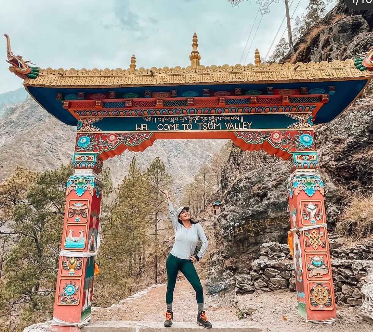
Tsum Valley Exploration Including Mu Gompa and Nile Village
Tsum Valley is why you add extra days to the basic Manaslu Circuit. This sacred hidden valley offers cultural and spiritual experiences found nowhere else in Nepal.
Entering Tsum Valley
The valley entrance at Philim marks a dramatic cultural shift. Below Philim, villages follow typical Nepali patterns with Hindu and Buddhist elements mixed. Above Philim, you enter purely Tibetan Buddhist territory. Prayer flags replace Hindu shrines. Mani walls carved with Buddhist mantras line the trails. Chortens mark village entrances.
The Tsumba people who inhabit this valley trace their ancestry to Tibet. Their language is a Tibetan dialect distinct from Nepali. Their architecture, dress, food, and customs all reflect Tibetan heritage preserved through centuries of isolation.
Hunting and killing animals are strictly forbidden by religious law throughout Tsum Valley. This Buddhist prohibition creates a peaceful beyul, a sacred hidden sanctuary. Even agriculture adapted to avoid harming life, with farming techniques designed to minimize insect deaths.
Chumling and Lower Tsum
Chumling at 2,385 meters serves as the gateway to upper valley. The village sprawls across terraced fields growing barley, buckwheat, and potatoes. Stone houses with flat roofs and intricately carved wooden windows create stunning architecture. Prayer wheels beside the trail spin constantly from water power.
The lower valley between Philim and Chumling shows farming communities still living traditional lifestyles. You see families working fields by hand, using wooden plows pulled by yaks or dzo (yak cattle crossbreed). Grain gets threshed by hand or by animals walking circles over harvested crops.
Women work looms weaving wool into blankets and clothing. Monastery schools teach children Tibetan language and Buddhist scriptures alongside basic Nepali curriculum. Daily life revolves around agricultural seasons and religious calendars marking festivals and ceremonies.
Chhokang Paro and Middle Valley
Chhokang Paro at 3,030 meters sits in a spectacular location with mountain views in all directions. Ganesh Himal, Buddha Himal, Himal Chuli, and Sringi Himal surround the valley. The village monastery contains beautiful murals and religious artifacts accumulated over centuries.
This section of valley shows increasing Tibetan cultural influence. Almost everyone wears traditional dress: long woolen robes tied with sashes, heavy boots, coral and turquoise jewelry. Older villagers speak only Tibetan with limited Nepali. Prayer beads appear in every hand.
The trail between villages follows ancient trade routes to Tibet. Before borders closed, traders moved salt, wool, and livestock between lowland Nepal and the Tibetan plateau. These routes connected Tsum Valley to the broader Himalayan trade network. Now they serve mainly local traffic and trekkers.
Nile Village
Nile at 3,360 meters sits higher still, perched on a mountainside with increasingly barren surroundings. Trees become scarce. Agriculture barely survives at this elevation. The growing season is too short for most crops, allowing only fast maturing varieties of barley and buckwheat.
Nile village showcases classic Tibetan architecture adapted to extreme conditions. Houses are built from stone with tiny windows to conserve heat. Roofs are flat, constructed from wooden beams covered with earth and stones. Storage lofts hold winter food supplies and fodder for livestock.
Villagers supplement agriculture with herding. Yaks and sheep graze on high pastures in summer, providing milk, meat, and wool. Some families maintain herds of 50 to 100 animals, moving them seasonally to different elevations following the grass.
The village monastery serves as community center for religious life. Daily prayer sessions bring villagers together. Major festivals see elaborate ceremonies with masked dances, religious dramas, and days of celebration. Even without festivals, religious devotion permeates daily life.
Mu Gompa
Mu Gompa at 3,700 meters marks the upper end of habitable Tsum Valley. The monastery clings to a steep mountainside with the Tibetan border visible just kilometers away. This location is stunning: barren peaks surrounding a collection of white buildings marked by prayer flags and painted religious symbols.
About 30 to 40 monks live year round at Mu Gompa despite brutal winter conditions. They maintain daily prayer schedules, study religious texts, and perform ceremonies for the valley’s Buddhist community. The monastery dates back several centuries with buildings reconstructed and renovated over generations.
Visiting Mu Gompa requires respectful behavior. Remove shoes before entering temple buildings. Ask permission before photographing inside. Donations to the monastery are appropriate and support the monks’ basic needs. Attending morning or evening prayers offers insight into Buddhist practice, though you sit quietly observing rather than participating.
The views from Mu Gompa rival anywhere in the Himalayas. Peaks on the Nepal Tibet border surround you. The valley drops away steeply below. On clear days you can see far into Tibet across the border.
Rachen Gompa
Rachen Gompa at 3,250 meters is Nepal’s largest nunnery with about 80 Buddhist nuns in residence. The nunnery compound includes temple buildings, living quarters, and study halls where nuns pursue religious education.
Unlike monks who often come from families dedicating sons to monasteries, many nuns chose religious life themselves. Some entered as young girls, others later after marriages ended or children grew. All maintain vows of celibacy and devotion to Buddhist practice.
The nuns welcome visitors with friendly curiosity. Few speak English but communication happens through smiles and gestures. They conduct daily prayers in the main temple, and visitors can observe these ceremonies. The sound of 80 voices chanting together in the dim temple lit only by butter lamps creates powerful atmosphere.
Rachen Gompa also runs small businesses to support the nunnery. They sell handmade crafts, prayer flags, and religious items to trekkers. Buying these products directly supports the community.
Milarepa’s Cave
Milarepa, Tibet’s most famous yogi and poet, meditated in caves throughout the Himalayas during the 11th century. One of his meditation caves lies in Tsum Valley at Piren Phu. The cave contains ancient religious paintings and carved stones marking it as sacred.
Buddhist pilgrims visit to pray and meditate where Milarepa achieved enlightenment. The cave is small and dark, carved into a cliff face. Inside, butter lamps flicker before religious images. The atmosphere feels charged with centuries of devotion.
Reaching the cave requires a short detour from the main trail. The path climbs steeply to a cliffy area where the cave entrance appears. Visiting requires removing shoes and behaving reverently in this sacred Buddhist site.
Cultural Significance
Tsum Valley represents one of the last places where traditional Tibetan Buddhist culture survives relatively intact. The Chinese occupation of Tibet destroyed much of the cultural and religious heritage there. Tsum Valley, protected by isolation and Nepali sovereignty, preserved what was lost across the border.
Walking through Tsum Valley lets you witness a culture that has existed essentially unchanged for centuries. This is not a reconstruction or museum display. This is people living traditional lives because that is how their families have always lived.
The valley also holds deep significance as a beyul, a sacred sanctuary designated by Padmasambhava (Guru Rinpoche) who brought Buddhism to Tibet in the 8th century. Beyuls serve as refuges where Buddhist teachings and practice survive even during dark times. Tsum Valley fulfilled this role, preserving Buddhism through centuries when it faced threats elsewhere.
Best Time for Manaslu Tsum Valley Trek with Seasonal Breakdown
Choosing the right season dramatically affects your Manaslu Tsum Valley Trek experience. Each season offers distinct advantages and challenges.
Autumn Season (September to November)
Autumn is the most popular and arguably best season for the Manaslu Tsum Valley Trek. September through November brings stable weather, clear skies, and perfect temperatures.
September still catches the tail end of monsoon, especially early September. Trails can be muddy and leeches present at lower elevations. But by mid September, weather typically stabilizes. Mornings dawn clear and remain so most days. Afternoon clouds sometimes build but rarely bring serious rain.
October offers peak conditions. Stable high pressure systems settle over the Himalayas. Days are clear, crisp, and perfect for trekking. Temperatures during the day are comfortable even in t-shirts at lower elevations, though mornings and evenings get cold. At high altitude nights drop well below freezing.
November continues good weather though temperatures fall as winter approaches. Early November remains excellent. Late November can see the first major winter storms bringing heavy snow to the pass. Days grow noticeably shorter with darkness by 5 PM.
Visibility in autumn is exceptional. The monsoon rains have washed dust from the air. Mountains appear crisp and detailed even from great distances. Photography is outstanding with clean light and dramatic contrast.
Crowds are highest in October. This is peak season across Nepal and the Manaslu Tsum Valley Trek sees its busiest months. Teahouses fill up, though the region is less crowded than Everest or Annapurna. You might see 30 to 50 other trekkers during October compared to hundreds on more popular routes.
Spring Season (March to May)
Spring is the second most popular season, offering excellent conditions with different character than autumn.
March starts cold with winter conditions lingering at high elevations. Larkya La Pass often has significant snow making the crossing challenging. Lower elevations begin warming but nights remain cold. By late March, conditions improve notably.
April brings the best spring weather. Temperatures warm considerably. Days are pleasant for walking. The snow line retreats to above 4,500 meters. Rhododendron forests at mid elevations burst into bloom, creating spectacular displays of red, pink, and white flowers covering entire hillsides.
May grows increasingly warm, sometimes uncomfortably hot at lower elevations. The high country remains pleasant but heat builds during midday. Pre monsoon haze begins reducing visibility compared to autumn. Afternoon clouds and occasional thunderstorms become more common as monsoon approaches.
Visibility in spring is generally good early in the season but deteriorates somewhat by May. Mornings typically start clear but clouds build through the day. Mountain views are best at dawn.
Crowds in spring are significant but not quite as heavy as autumn October. April sees the most trekkers. March and May are quieter.
The rhododendron blooms make spring special. If you time the trek for late March through mid April, you walk through forests exploding with flowers. This creates photograph opportunities and beauty that autumn cannot match.
Winter Season (December to February)
Winter brings extreme cold and challenges but rewards hardy trekkers with crystal clear views and complete solitude.
December transitions from autumn to full winter. Early December can still offer decent conditions. By mid December, winter settles in with freezing temperatures and potential heavy snowfall. The pass often becomes difficult or impossible without proper equipment.
January and February are brutally cold. Temperatures at high elevations regularly drop to minus 20 to minus 30 Celsius. Larkya La Pass is extremely challenging with deep snow and ice. Many teahouses in higher villages close for winter, moving to lower elevations. Those that remain open have minimal facilities.
Despite the cold, winter offers advantages. Visibility is extraordinary. The air is dry and clear. Mountains appear razor sharp against deep blue skies. Photography can be exceptional if you keep batteries warm enough to function.
Crowds are virtually nonexistent. You might be the only trekker on the trail for days. Teahouses welcome you warmly, grateful for business during the slow season. Prices may be negotiable.
Winter trekking requires serious preparation. You need excellent cold weather gear including a sleeping bag rated to minus 20 Celsius or colder, heavy down jacket, insulated pants, warm boots, and layering systems. Microspikes or crampons are often necessary for the pass.
Only experienced winter trekkers should attempt Manaslu Tsum Valley in December through February. The risks from cold and snow are real. But if you have the skills and equipment, winter offers an expedition style experience.
Monsoon Season (June to August)
Monsoon is the least popular season for good reasons, though the trek remains possible for adventurous trekkers willing to accept challenges.
June marks monsoon arrival. By mid June, afternoon storms become daily occurrences. Rain falls heavily for several hours most days, turning trails muddy and rivers swollen. Leeches infest forests at lower and middle elevations, making walking unpleasant.
July and August bring peak monsoon. Heavy rain is common. Trails become slippery and difficult. Landslides can block the route though the main trail gets cleared quickly. Clouds obscure mountain views most days. Even when not raining, humidity is high and visibility poor.
The advantages of monsoon trekking are limited but exist. The valleys are incredibly green and lush. Wildflowers bloom everywhere. Waterfalls cascade dramatically. You have trails essentially to yourself. Teahouses offer excellent service with no crowds. Prices drop considerably.
But the disadvantages outweigh benefits for most people. Rain and mud make walking miserable. Leeches are a constant annoyance. Mountain views, the main reason for trekking here, disappear behind clouds. Risks from landslides and swollen rivers increase. Most people choose other seasons.
Best Choice for Most Trekkers
For your first Manaslu Tsum Valley Trek, October or April offer the best chances of good weather, clear views, and successful pass crossing. October edges ahead with more stable conditions and better visibility. April wins if you want rhododendron blooms and warmer temperatures.
March and November work well if you want to avoid peak crowds while still getting decent weather. September and early December can work but require more flexibility in case weather delays the pass crossing.
Avoid monsoon unless you specifically want that experience and can handle the challenges. Avoid deep winter unless you have serious cold weather trekking experience and proper equipment.
Permits for Manaslu Tsum Valley Trek Including Restricted Area Rules
Trekking the Manaslu Tsum Valley route requires multiple permits due to the restricted area status. Understanding these permits, their costs, and how to obtain them is essential for planning.
Manaslu Restricted Area Permit (RAP)
This special permit is mandatory for trekking between Jagat and Samdo in the Manaslu region. The cost varies by season:
- September through November: USD 100 per person for first 7 days, USD 15 per person per day beyond 7 days
- December through August: USD 75 per person for first 7 days, USD 10 per person per day beyond 7 days
Most Manaslu Circuit treks take 8 to 10 days in the restricted area, so total RAP cost typically reaches USD 115 to 145 in autumn or USD 85 to 105 in other seasons.
The RAP can only be obtained through a registered trekking agency in Nepal. Individual travelers cannot apply directly. Your agency handles the paperwork using your passport photocopy, photos, and Nepal visa details.
Tsum Valley Restricted Area Permit
Tsum Valley requires a separate special permit since it is its own restricted region. Costs are:
- September through November: USD 40 per person for first 8 days, USD 7 per person per day beyond 8 days
- December through August: USD 30 per person for first 8 days, USD 7 per person per day beyond 8 days
The Tsum Valley portion typically takes 5 to 6 days, falling within the initial 8 day permit period. Total cost is USD 40 in autumn or USD 30 in other seasons for most trekkers.
Like the Manaslu RAP, this permit requires processing through a registered agency. You cannot obtain it independently.
Manaslu Conservation Area Permit (MCAP)
This permit supports conservation efforts in the Manaslu Conservation Area Project zone. The cost is fixed regardless of season:
- Foreign nationals: NPR 3,000 (approximately USD 23)
- SAARC nationals: NPR 1,000 (approximately USD 8)
The MCAP is valid for the entire trek within the conservation area boundaries, which covers most of the Manaslu Circuit route. You can obtain this permit through trekking agencies or directly at Nepal Tourism Board offices in Kathmandu or Pokhara.
Annapurna Conservation Area Permit (ACAP)
After crossing Larkya La Pass, you enter the Annapurna Conservation Area for the final descent to Dharapani. This requires:
- Foreign nationals: NPR 3,000 (approximately USD 23)
- SAARC nationals: NPR 1,000 (approximately USD 8)
Like MCAP, this permit is available through agencies or directly at tourism board offices and checkpoints.
Total Permit Costs
For the complete Manaslu Tsum Valley Trek, total permit costs are:
- Autumn (September to November): approximately USD 186 for foreign nationals
- Other seasons (December to August): approximately USD 156 for foreign nationals
These totals include Manaslu RAP, Tsum Valley permit, MCAP, and ACAP assuming standard trekking duration. SAARC nationals pay approximately USD 16 less due to reduced conservation area permit fees.
Restricted Area Regulations
The restricted area permits come with specific rules that strictly apply:
- Minimum group size: At least 2 trekkers must trek together. Solo trekking is prohibited.
- Licensed guide required: You must hire a government licensed guide through a registered agency.
- Agency booking mandatory: Only registered trekking companies can process restricted area permits.
These rules exist to protect the cultural and environmental integrity of the Manaslu region while ensuring trekker safety. The government uses permit fees for conservation projects, trail maintenance, and community development.
Attempting to trek without proper permits results in heavy fines and immediate evacuation from the area. Checkpoints at Jagat, Philim, Samagaon, and other points verify permits. Officers record your entry and exit dates.
Permit Processing
At Manaslu Treks and Expedition, we handle all permit processing for our clients. The process requires:
- Passport photocopy (photo page and Nepal visa page)
- 4 passport size photos
- Completed application forms
- Payment in USD or NPR equivalent
Processing takes 1 to 2 working days in Kathmandu. We need your original passport temporarily to submit to the Department of Immigration for restricted area permits. Conservation area permits process faster, sometimes same day.
Plan to arrive in Kathmandu at least 2 to 3 days before your trek starts. This allows time for permit processing, gear checks, and trek briefings. Weekend and public holidays close government offices, potentially causing delays.
TIMS Card
The Trekkers Information Management System (TIMS) card is NOT required for Manaslu Tsum Valley Trek. The restricted area permits serve the same tracking and safety functions that TIMS provides on other routes.
Permit Checkpoints
Your permits get checked and recorded at multiple points along the route:
- Jagat: Main entry checkpoint for Manaslu restricted area
- Philim: Entry checkpoint for Tsum Valley branch
- Chumling: Registration in Tsum Valley
- Lokpa: Additional Tsum Valley checkpoint
- Samagaon: Final Manaslu restricted area checkpoint before the pass
- Dharapani: ACAP checkpoint when exiting
Carry your permits in a waterproof document pouch with your passport at all times. Losing permits mid trek creates serious complications since replacements are difficult or impossible to obtain on trail.
At Manaslu Treks and Expedition, we ensure every client has proper permits before departing Kathmandu. Our guides carry copies as backup and know exactly how to handle checkpoint procedures.
Manaslu Tsum Valley Trek Cost with Realistic Breakdown
Understanding the real costs helps you budget accurately for the Manaslu Tsum Valley Trek. Prices vary based on group size, season, services included, and choice of operator.
Standard Trek Package Costs
At Manaslu Treks and Expedition, our complete 19 to 20 day Manaslu Tsum Valley Trek package costs:
- Group trek (4 to 6 people): USD 1,250 to 1,400 per person
- Private trek (2 people): USD 1,400 to 1,600 per person
- Solo traveler joining guide: USD 1,600 to 1,800
These prices include all services detailed below. Lower prices from other operators often exclude key items or use less experienced guides.
What’s Included in Our Package
Transportation:
- Private vehicle or tourist bus Kathmandu to Soti Khola
- Private jeep Dharapani to Kathmandu
Permits and fees:
- Manaslu Restricted Area Permit
- Tsum Valley Restricted Area Permit
- Manaslu Conservation Area Permit (MCAP)
- Annapurna Conservation Area Permit (ACAP)
- All government taxes
Guide and porter services:
- Government licensed experienced guide
- One porter for every two trekkers (carries up to 20kg total)
- Guide and porter wages, insurance, meals, accommodation, equipment
Accommodation:
- 2 nights hotel in Kathmandu before and after trek (twin sharing)
- 17 to 18 nights teahouse lodges during trek (twin sharing)
Meals during trek:
- Breakfast, lunch, dinner for entire trekking duration
- Tea or coffee with meals
- Seasonal fruit when available
Equipment provided free:
- Duffle bag for porter to carry
- Sleeping bag if needed
- Down jacket if needed
- Company t shirt
- Trekking map
- First aid kit
Support:
- Pre trek briefing and gear check
- 24 hour emergency support
- Trekking completion certificate
What’s NOT Included
- International flights to/from Nepal
- Nepal visa fee (USD 50 for 30 days)
- Meals in Kathmandu (except breakfast if included with hotel)
- Travel insurance (mandatory)
- Personal trekking gear (boots, clothes, backpack)
- Hot showers at lodges (USD 2 to 4 per shower)
- Battery charging at lodges (USD 1 to 3 per charge)
- WiFi access at lodges (USD 3 to 5 per day where available)
- Bottled or filtered water beyond boiled water from lodges
- Snacks and extra drinks beyond included meals
- Tips for guide and porter (customary)
- Personal expenses (souvenirs, extra snacks, alcohol)
- Rescue evacuation if needed (covered by insurance)
Daily Expenses on Trail
Budget approximately USD 15 to 25 per day for extras not covered in the package:
- Water and drinks: USD 3 to 6 daily (bottled water gets expensive at altitude)
- Hot showers: USD 2 to 4 every 2 to 3 days
- Charging devices: USD 2 to 4 daily
- Snacks: USD 3 to 6 daily (chocolate, cookies, fruit)
- WiFi: USD 3 to 5 daily where available (connection is slow and limited)
- Extra meals or drinks: USD 3 to 8 if ordering beyond package meals
Total extra expenses for 18 days of trekking typically run USD 250 to 400.
Tipping Guidelines
Tipping is customary in Nepal for good service. Standard amounts for the full trek:
- Guide: USD 120 to 150 total
- Porter: USD 80 to 100 total
Adjust based on service quality and group size. For larger groups, guides often earn slightly more. Tips are usually given on the final trekking day in sealed envelopes with thank you notes.
Complete Trip Budget
For the full Manaslu Tsum Valley Trek experience including package cost, extras, tips, and Kathmandu expenses:
Budget traveler: USD 1,700 to 2,000
- Package: USD 1,300
- Trek extras: USD 250
- Tips: USD 100
- Kathmandu meals and expenses: USD 80
Mid range traveler: USD 2,000 to 2,400
- Package: USD 1,500
- Trek extras: USD 350
- Tips: USD 150
- Kathmandu meals, activities, shopping: USD 150
Comfortable budget: USD 2,400 to 2,800
- Package: USD 1,700
- Trek extras: USD 400
- Tips: USD 200
- Kathmandu comfortable hotels, dining, activities: USD 250
Add international flights (USD 600 to 1,500 depending on origin), visa (USD 50), and travel insurance (USD 100 to 200) to these figures for total trip cost.
Cost Comparison with Other Treks
The Manaslu Tsum Valley Trek costs more than shorter, more accessible treks but remains reasonable for what you experience:
- Poon Hill Trek (7 days): USD 500 to 700
- Langtang Valley Trek (9 days): USD 700 to 900
- Annapurna Base Camp Trek (10 days): USD 800 to 1,000
- Everest Base Camp Trek (14 days): USD 1,200 to 1,500
- Manaslu Circuit Trek (14 days): USD 1,000 to 1,200
- Manaslu Tsum Valley Trek (20 days): USD 1,250 to 1,600
The higher cost reflects longer duration, restricted area permits, mandatory guide requirement, and remoteness requiring longer drives. For a full breakdown, see our detailed Manaslu Circuit Trek cost and itinerary.
Money Matters
Bring sufficient Nepali Rupees cash before starting the trek. No ATMs exist on the trail. Some lodges accept USD but at poor exchange rates. Credit cards work nowhere in the trekking region.
Withdraw cash in Kathmandu before departure. Bring small denomination notes (NPR 100, 500, 1000) for easier transactions. Keep money secure in a money belt or neck pouch.
Value Assessment
The Manaslu Tsum Valley Trek offers outstanding value. You spend 3 weeks exploring one of Nepal’s most pristine regions with spectacular mountains, authentic culture, and genuine wilderness for less than USD 2,500 total cost including flights from most countries.
Compare this to commercial adventure trips in other parts of the world charging USD 4,000 to 8,000 for similar durations. The Manaslu Tsum Valley Trek delivers authentic adventure at prices that make sense for most travelers.
At Manaslu Treks and Expedition, we believe in fair, transparent pricing. Our guides and porters earn proper wages. We use quality lodges and provide comprehensive support. You pay for actual services, not corporate overhead or excessive profit margins.
Accommodation and Food During Manaslu Tsum Valley Trek
Understanding teahouse conditions and food options helps set realistic expectations for the Manaslu Tsum Valley Trek.
Teahouse Lodge Standards
Accommodations on this trek are basic mountain lodges, locally called teahouses. These are family run guesthouses ranging from simple to relatively comfortable.
Lower elevations (Soti Khola to Philim): Lodges here are the most developed with concrete or stone buildings, multiple stories, decent sized rooms. Some have attached bathrooms with squat or western toilets. Solar power provides electricity for lighting and limited charging.
Middle elevations (Philim to Samagaon): Lodges become simpler, mostly traditional stone buildings. Rooms are small with twin beds, thin foam mattresses, and pillows. Bathrooms are shared, usually outside the main building. Toilets are mix of squat and western style. Hot water comes from solar when available or by request for fee.
High elevations (Samdo and Dharamsala): Very basic stone shelters. Rooms are tiny, sometimes just sleeping platforms in shared spaces. Bathrooms are basic pit toilets. No running water. Minimal heating except the dining room stove.
All lodges provide:
- Bed with mattress, pillow, and blankets
- Communal dining room with wood or yak dung stove
- Basic meals
- Toilet facilities (varying quality)
- Some form of washing water (cold)
Do not expect:
- Heated rooms (only dining areas have stoves)
- Private bathrooms except lower lodges
- Hot showers without paying extra
- Western cleanliness standards
- Reliable electricity
- WiFi that actually works well
Sleeping Arrangements
Rooms contain two single beds or occasionally a double bed. Most rooms sleep two people. Solo trekkers usually share rooms or pay extra for private room if available. Mattresses are thin foam, 5 to 8 cm thick. Pillows are small and firm.
The lodges provide thick blankets, but these are often insufficient at high altitude. Bring a good sleeping bag rated to at least minus 10 Celsius for comfort. In winter, you need minus 20 Celsius rating or colder.
Walls are thin. You hear everything from neighboring rooms. Earplugs help significantly for light sleepers.
Bathroom Facilities
Shared bathrooms are standard except at a few lower elevation lodges. Toilets range from basic pit latrines to semi modern squat toilets to occasional western toilets. Toilet paper is not provided, so bring your own supply.
Showers exist at many lodges but are cold unless you pay for hot water. A bucket of hot water costs NPR 200 to 500 (USD 1.50 to 4) depending on lodge and altitude. Solar heated showers work when sun has been strong, but this is unreliable.
Honestly, most trekkers shower every 3 to 4 days or skip showers entirely. The cold and effort of heating water make frequent washing impractical. Wet wipes serve for basic cleaning between showers.
Dining Rooms
The dining room is the social center and only heated space in each lodge. A wood or yak dung stove provides warmth, though rooms still get cold at night. Everyone gathers here for meals and evening socializing.
Long tables with benches provide seating. The atmosphere is communal with trekkers from different groups mingling. Conversations, card games, and shared trekking stories fill evening hours.
Food and Menus
Lodge menus are surprisingly varied considering the remote location. Dal bhat, Nepal’s staple meal, appears on every menu alongside international options adapted for mountain cooking.
Typical breakfast options:
- Porridge with honey or sugar
- Toast with jam, peanut butter, or cheese
- Tibetan bread (fried flatbread)
- Eggs (fried, scrambled, boiled, omelet)
- Pancakes (plain, banana, apple, chocolate)
- Hash browns
- Muesli with milk
- Tea, coffee, hot chocolate
Lunch and dinner menus:
- Dal bhat (rice, lentil soup, vegetable curry, pickle, papadum) with unlimited refills
- Fried rice (vegetable, egg, chicken, mixed)
- Chow mein (fried noodles)
- Thukpa (Tibetan noodle soup)
- Momos (dumplings, steamed or fried)
- Pizza (basic but edible)
- Pasta dishes
- Spring rolls
- Sherpa stew
- Soups (vegetable, mushroom, garlic, noodle)
Drinks:
- Tea (black, milk, lemon, ginger, masala)
- Coffee (instant Nescafe usually)
- Hot lemon honey
- Hot water (for your own tea/coffee)
- Soft drinks (Coke, Sprite, Fanta where available)
- Beer (limited availability, expensive at altitude)
Dal Bhat Recommendation
We strongly encourage eating dal bhat for at least one meal daily. This traditional meal provides complete nutrition: carbohydrates from rice, protein from lentils, vitamins from vegetables, plus pickles for flavor and digestion. Most lodges offer unlimited refills of rice and dal.
Dal bhat costs about the same as other main dishes but provides much more food value. It also supports local food traditions and uses ingredients produced in Nepal rather than imported pasta or other foreign items.
Food Safety and Vegetarian Options
Vegetarian food is abundant, safe, and actually recommended over meat at high altitudes. Meat must be carried up from lower villages without refrigeration, creating food safety concerns. Vegetables, lentils, rice, eggs, and cheese are fresh and reliable.
If you eat meat, buffalo (buff) is safer than chicken. Ensure everything is thoroughly cooked. Avoid salads or raw vegetables washed in potentially contaminated water.
Water
Tap water is unsafe to drink. Options for drinking water:
- Boiled water from lodges: Free or small fee (NPR 50 to 100 per liter), safest option
- Water purification tablets: Treat your own water from taps or streams
- Water filters: Sawyer, LifeStraw, or similar systems work well
- Bottled water: Available but expensive and environmentally terrible
Bottled water costs escalate with altitude:
- Lower elevations: NPR 100 to 150 (USD 0.75 to 1)
- Middle elevations: NPR 150 to 250 (USD 1 to 2)
- High elevations: NPR 250 to 400 (USD 2 to 3)
We strongly discourage bottled water. The plastic waste in mountains is devastating. Use refillable bottles with purification tabs or filters instead.
Lodge Etiquette
Important rules for teahouse staying:
- Order food where you sleep. Lodges make money from meals, not rooms which are often free or very cheap. Eating dinner and breakfast at your sleeping lodge is expected.
- Be patient with food preparation. Kitchens serve many trekkers from limited equipment. Your meal might take 45 minutes to arrive during busy times.
- Order together as a group when possible. This helps kitchens prepare efficiently.
- Understand extra costs. Hot showers, charging, WiFi all cost extra because they require fuel or solar power that has value.
- Respect quiet hours after 9 PM. Lodge walls are thin and everyone needs sleep for next day’s trekking.
- Treat lodge families with courtesy. They work incredibly hard providing services in difficult conditions.
Dietary Restrictions
- Vegetarian: Easy, plentiful options everywhere
- Vegan: Manageable with advance communication to avoid dairy, eggs, ghee
- Gluten free: Difficult but possible focusing on rice based meals, potatoes, eggs
- Other allergies: Inform your guide so they can communicate to lodges
Lodge kitchens are basic and cross contamination is common. If you have severe allergies, bring backup food and communicate very clearly about your needs.
Transportation from Kathmandu to Starting Point and Return
Getting to and from the Manaslu Tsum Valley Trek starting point involves a full day of road travel each direction.
Kathmandu to Soti Khola
The trek traditionally started from Arughat or Soti Khola. Recent road construction now pushes vehicle access higher to Machha Khola, though road conditions are rough.
Manaslu Treks and Expedition typically uses private jeep or local bus transportation. The journey covers approximately 140 to 160 kilometers depending on exact starting point, taking 7 to 9 hours.
The route follows:
- Kathmandu to Malekhu (65 km, 2 hours): Drive follows the Prithvi Highway west toward Pokhara. This section is paved and relatively fast. You pass through Naubise, Malekhu riverside town.
- Malekhu to Dhading Besi (35 km, 1.5 hours): Road continues on highway, then branches north toward Dhading. Still mostly paved but narrower with more traffic.
- Dhading Besi to Arughat (30 km, 1.5 hours): Road deteriorates significantly. Rough gravel or dirt in sections. Winding through hills with dramatic drops visible from the road.
- Arughat to Soti Khola/Machha Khola (30 to 40 km, 2 to 3 hours): Very rough road, sometimes barely more than a track. Slow going with bumps, rocks, and stream crossings. The final stretch is particularly challenging.
Vehicle Options
- Private jeep (7 to 10 passengers): USD 250 to 350 for entire vehicle. This is most common and allows flexibility for stops, comfortable seating, and direct hotel to trailhead service.
- Local bus: USD 8 to 12 per person. Cheaper but crowded, uncomfortable, and runs on fixed schedules regardless of your timing. Not recommended for groups.
- Tourist bus to Dhading Besi then local jeep: USD 15 to 20 per person. Hybrid option using tourist bus for paved sections, then sharing jeep for rough final section.
At Manaslu Treks and Expedition, we include private jeep transportation in our standard packages. The cost difference is minimal and the comfort and flexibility worthwhile.
Road Conditions and Experience
Be prepared for a genuinely rough drive. The road from Arughat to Machha Khola is terrible by any standard. Potholes, rocks, narrow sections, stream crossings. The jeep bounces and jolts constantly. Motion sickness is common, so bring medication if you are prone to it.
The scenery is spectacular as you climb into the mountains. Terraced fields, traditional villages, river gorges, forested hillsides. Stop for photos at scenic viewpoints, tea breaks, and lunch.
Lunch typically happens in Arughat, the last town with restaurants before entering more remote areas. The meal break takes 30 to 45 minutes.
Landslides can block roads during monsoon or after heavy rain. Road crews usually clear blockages within hours, but delays are possible. This is why starting the trek with buffer days in your schedule helps avoid stress from delays.
Dharapani to Kathmandu Return
The return journey follows a different but equally rough route. From Dharapani, you join the road that services the lower Annapurna Circuit trail.
- Dharapani to Besisahar (50 km, 2 to 3 hours): Very rough road winding down the Marsyangdi River valley. Slow going with many bumps.
- Besisahar to Dumre (50 km, 1.5 to 2 hours): Road improves somewhat. Still winding but better surface.
- Dumre to Kathmandu (140 km, 4 to 5 hours): Join the main Prithvi Highway. Paved and relatively fast return to Kathmandu.
Total return journey takes 7 to 9 hours depending on traffic and road conditions.
Timing Recommendations
Plan to leave Kathmandu early for the drive to Soti Khola, ideally by 6 to 7 AM. This gets you to the trailhead by mid afternoon with time to settle into your first lodge.
The return drive from Dharapani can start later, around 8 to 9 AM after breakfast, arriving Kathmandu late afternoon or early evening.
Build flexibility into your schedule. Road conditions, landslides, vehicle breakdowns can all cause delays. Having an extra buffer day in Kathmandu before departing Nepal prevents stress from missing international flights.
Altitude Sickness Prevention and Acclimatization Tips
Altitude sickness is a real concern on the Manaslu Tsum Valley Trek with maximum altitude of 5,160 meters. Understanding altitude effects and proper acclimatization keeps you safe.
Altitude Physiology
As elevation increases, air pressure decreases. At 5,160 meters, the air contains about 50 percent of the oxygen available at sea level. Your body must adapt to function on less oxygen.
Adaptation involves producing more red blood cells to carry oxygen, increasing breathing rate, and other physiological changes. These adaptations take time, typically several days to weeks for full adjustment.
If you climb faster than your body can adapt, altitude sickness results. Symptoms range from mild discomfort to life threatening conditions.
Altitude Sickness Symptoms
Mild symptoms (common and normal):
- Mild headache
- Slight nausea or reduced appetite
- Difficulty sleeping or unusual dreams
- Increased urination
- Shortness of breath with exertion
- Mild dizziness when standing quickly
These symptoms affect nearly everyone at some point during the trek. They indicate your body is working to adapt and usually resolve with rest and hydration.
Moderate symptoms (warning signs):
- Severe headache not relieved by pain medication
- Persistent nausea or vomiting
- Extreme fatigue beyond normal tiredness
- Dizziness or lightheadedness at rest
- Rapid heartbeat at rest
Severe symptoms (emergency):
- Severe shortness of breath at rest
- Coughing up pink or frothy fluid
- Confusion or altered mental state
- Loss of coordination or difficulty walking
- Severe persistent vomiting
Severe symptoms require immediate descent and medical evaluation.
Prevention Strategies
- Proper acclimatization schedule: The itinerary includes rest days at Samagaon and gradual ascent. Follow this schedule religiously. Do not skip acclimatization days or climb too fast.
- Climb high, sleep low: On rest days, hike to higher elevations during the day but return to sleep at lower altitude. This accelerates adaptation.
- Hydration: Drink 3 to 4 liters of water daily. Dehydration worsens altitude symptoms. Your urine should be clear or pale yellow.
- Avoid alcohol: Alcohol dehydrates and impairs breathing during sleep, worsening altitude effects. Skip drinking until after descending below 3,000 meters.
- Light meals: Eat regular meals despite reduced appetite. Carbohydrates are especially important for energy at altitude. But avoid overeating which stresses digestion.
- Slow steady pace: Walk slowly, much slower than you would at sea level. Let your breathing stay comfortable. Racing uphill guarantees problems.
- Listen to your body: If you feel unwell, tell your guide immediately. Minor symptoms can escalate quickly if ignored.
Diamox (Acetazolamide)
This medication helps prevent and treat altitude sickness. It works by increasing breathing rate, helping your body adapt faster.
Standard dosage: 125 mg twice daily starting 1 to 2 days before reaching 3,000 meters, continuing until starting descent.
Side effects include tingling fingers and toes, increased urination, altered taste of carbonated drinks, and rarely, allergic reactions.
Diamox is not mandatory for this trek but many doctors recommend it for anyone going above 4,000 meters. Consult your doctor about whether it makes sense for you.
Even with Diamox, you must still acclimatize properly. The medication helps but does not replace gradual ascent.
When to Descend
If symptoms worsen despite rest and treatment, descent is the only solution. Even descending 300 to 500 meters often brings dramatic improvement.
Never ascend with worsening symptoms. This is dangerous. Pride or schedule concerns are not worth risking your life.
If severe symptoms appear (confusion, inability to walk straight, coughing fluid, severe breathlessness), descend immediately even if it means walking through the night. This is a medical emergency.
Evacuation Options
Helicopter evacuation is possible from Samagaon, Samdo, and even Dharamsala in good weather. Rescue costs USD 3,000 to 5,000 and must be paid upfront, then claimed from your travel insurance.
Below Samagaon, evacuation typically means walking down with porter assistance until reaching road access.
Your travel insurance MUST cover helicopter evacuation from 6,000 meters even though this trek does not reach that high. Many policies require this minimum coverage amount.
Packing List for Manaslu Tsum Valley Trek
Packing correctly balances bringing everything needed against carrying excessive weight. This list reflects real experience guiding this trek.
Clothing (Layering System)
Base layers:
- 3 to 4 sets thermal underwear (top and bottom, synthetic or merino wool)
- 4 to 5 trekking shirts (long sleeve, moisture wicking)
- 1 to 2 short sleeve shirts for lower elevations
- Never cotton which stays wet and loses insulation
Mid layers:
- Fleece jacket or pullover (medium weight)
- Insulated synthetic jacket (Primaloft or similar)
- Down vest (optional but useful)
Outer layers:
- Waterproof jacket (must be actually waterproof, not just water resistant)
- Waterproof pants (essential in monsoon, useful any season)
- Soft shell jacket or wind shirt (optional)
Lower body:
- 2 to 3 trekking pants (quick dry, comfortable)
- Thermal leggings for cold
- Shorts (optional for warm lower sections)
Extremities:
- Warm wool or synthetic hat
- Sun hat or cap with brim
- Buff or neck gaiter (versatile protection)
- Liner gloves plus insulated gloves or mittens
- 5 to 6 pairs thick trekking socks (wool or synthetic, never cotton)
- 5 to 6 pairs underwear (synthetic quick dry)
Footwear
- Hiking boots (broken in, waterproof, ankle support, aggressive tread)
- Camp shoes (sandals, Crocs, or lightweight shoes for evenings)
- Gaiters (optional, useful for snow, mud, or stream crossings)
Backpack and Bags
- Daypack 30 to 40 liters for daily use
- Duffel bag for porter to carry (provided by us)
- Dry bags or waterproof stuff sacks for organizing gear
- Daypack rain cover
Trekking Equipment
- Trekking poles (absolutely essential for pass descent)
- Headlamp with extra batteries (critical for pass crossing)
- Sunglasses (category 3 or 4 UV protection, essential)
- Water bottles 2 x 1 liter or hydration bladder
- Water purification (tablets, filter, or UV device)
- Sleeping bag rated to minus 15 to minus 20 Celsius (provided by us if needed)
- Sleeping bag liner (adds warmth and hygiene)
Personal Items
- Sunscreen SPF 50+ (sun is intense, reapply frequently)
- Lip balm with SPF (lips crack and burn easily)
- Toothbrush and toothpaste
- Biodegradable soap (small bottle)
- Quick dry towel (small)
- Toilet paper (lodges provide but bring backup)
- Wet wipes (invaluable when showers unavailable)
- Hand sanitizer
- Personal medications
First Aid and Medical
- Blister treatment (Compeed, moleskin)
- Pain relievers (ibuprofen, paracetamol)
- Altitude sickness medication (Diamox if prescribed)
- Anti diarrhea medication (Imodium)
- Antibiotics (if prescribed by doctor)
- Rehydration salts
- Throat lozenges
- Antiseptic cream
- Band aids and medical tape
Electronics
- Camera with extra batteries and memory cards
- Smartphone
- Power bank 20,000 mAh minimum (charging costs add up)
- Charging cables
- Universal adapter (Nepal uses European style round pins)
- Earbuds
- E reader or book (for evening entertainment)
Documents and Money
- Passport with Nepal visa
- Travel insurance policy and emergency numbers
- Passport photos (2 to 3 extras for permits if needed)
- Cash in Nepali Rupees (sufficient for entire trek)
- Some USD bills (emergency backup)
- Credit card (limited use but good backup)
Weight Limits
Your porter carries your main duffel with maximum 10 kg per trekker (20 kg shared between two trekkers). Pack accordingly.
Your daypack should weigh 5 to 7 kg maximum including water, snacks, camera, rain gear, warm layer, first aid, sunscreen, and documents.
Why Choose Manaslu Treks and Expedition
Selecting the right trekking company determines whether your Manaslu Tsum Valley Trek succeeds or struggles. Here is why Manaslu Treks and Expedition should guide your journey.
Local Expertise
We are not a Kathmandu agency that works in multiple regions. Manaslu is our specialty. Our name reflects our focus. We operate treks exclusively in the Manaslu area including Manaslu Circuit, Manaslu Tsum Valley, and Manaslu Base Camp routes.
Our guides are from villages along the trek route. They grew up walking these trails, know every village family, speak the local languages, and understand the culture intimately. This is their home, not just their workplace.
Safety Record
In our years operating Manaslu treks, we have maintained an excellent safety record. We have successfully guided hundreds of clients over Larkya La Pass without serious incidents.
Our guides carry proper first aid equipment, pulse oximeters, and emergency communication devices. They are trained in altitude sickness recognition and response protocols.
We never pressure clients to continue if conditions are unsafe or if altitude symptoms appear. Your safety matters more than summit success rates.
Fair Treatment of Staff
We pay guides and porters proper wages significantly above minimum standards. They receive quality equipment, insurance coverage, and meals equal to trekker meals.
Porters never carry excessive loads beyond the agreed 20 kg for two trekkers. We provide rest days for staff, not just clients.
Our employment practices support families in Manaslu communities. Choosing us supports fair labor standards, not exploitation.
Transparent Pricing
Our prices clearly state what is included and excluded. We do not use bait pricing that appears cheap then adds fees later.
Compare our packages item by item with competitors. We include services that others charge extra for.
We never demand tips or pressure clients for additional payments. Tipping remains optional based on service quality.
Customization Options
We offer standard 19 to 20 day itineraries but customize readily for your needs. Want extra acclimatization days? We add them. Want to skip Tsum Valley and do basic Manaslu Circuit? We adjust. Want to add Manaslu Base Camp side trip? No problem. Need vegetarian or special dietary accommodation? We arrange it.
Private trips allow complete flexibility in pacing, rest days, and route variations.
Quality Equipment Provided
We provide sleeping bags rated to minus 20 Celsius and quality down jackets free with our packages. These are clean, well maintained items we own, not cheap rentals.
Duffel bags for porters to carry are included. We supply comprehensive first aid kits, not minimal token supplies.
Communication and Support
From initial inquiry through trek completion, we respond promptly to questions and concerns.
Before departure, we provide detailed briefings on what to expect, how to prepare, and what to pack.
During the trek, guides maintain communication with our Kathmandu office for support and coordination.
After the trek, we welcome feedback and stay in touch with past clients.
Value for Money
Our prices reflect fair value. We use quality services without wasteful luxury. You pay for experienced guides, good food, proper permits, and comprehensive support, not corporate overhead or excessive profit margins.
Many clients tell us we deliver better value than cheaper operators who cut corners on guides, food quality, or safety equipment.
The Manaslu Tsum Valley Trek is challenging and remote. Having an experienced, reliable company managing logistics and safety makes the difference between a successful adventure and a stressful struggle.
Manaslu Treks and Expedition has built our reputation on getting clients safely across Larkya La Pass while providing cultural insights and experiences that create lasting memories. We would be honored to guide your Manaslu Tsum Valley adventure.