Most people who fly into Kathmandu for the Manaslu Circuit Trek never hear the word Tsum until they are already walking. You come up from Soti Khola through Machhakhola and Jagat, you eat your dal bhat in Philim under the fig trees, and then somewhere around Nyak or Lokpa your guide points up a side valley and mentions, almost casually, that there is another world up there. That other world is Tsum, and it deserves more than a mention.
The Tsum Valley sits in the northern reaches of Gorkha district, tucked behind the main Manaslu massif and wedged between the Ganesh Himal, the Sringi Himal and the Boudha Himal. It was closed to foreigners for most of modern Nepali history and only opened for restricted trekking in the mid to late 2000s (different sources give 2007 or 2008, and we could not find one document that settles the exact year beyond doubt, so treat either date as roughly right rather than precise). The valley runs east to west along the Shyar Khola, a tributary that eventually drops down to meet the Budhi Gandaki, and it is home to the Tsumba, an ethnic Tibetan Buddhist community with their own dialect, their own festivals and, famously, a long standing local tradition of refusing to kill animals.
This guide walks the route the way your feet will actually experience it, village by village, from the junction near Lokpa where the trail splits off the main Manaslu Circuit Trek, up through Chumling and Chhekampar (often written Chhokangparo), past Lamagaon and the cave associated with the saint Milarepa, through Nile and Chhule to Mu Gompa at the head of the valley, with notes on the nunnery at Rachen Gompa and the side trip up to Gumba Lungdang. We have cross checked altitudes and walking times against several trekking companies, Wikipedia, an older Swiss trekking reference site, and a conservation document published on Mu Gompa itself. They do not always agree, and where they disagree we say so rather than quietly picking the number that sounds best.
Tsum Valley Trek Stops at a Glance
Before the detail, here is the route laid out as a quick reference. Altitudes and walking times below are approximate and drawn from multiple sources that do not always match each other exactly, so use this table for planning your days rather than as a survey grade record. Where the spread between sources was wide, we have noted the range rather than a single figure.
| Stop | Approximate altitude | Approximate time from previous stop |
|---|---|---|
| Lokpa | About 1,900 to 2,240 meters (sources disagree sharply) | 5 to 7 hours up from Jagat |
| Chumling | About 2,386 meters | 4 to 6 hours from Lokpa |
| Chhekampar / Chhokangparo | About 3,030 meters by most trekking sources, though one reference gives 3,501 meters | 4 to 6 hours from Chumling |
| Lamagaon, Milarepa’s Cave and Rachen Gompa | Roughly 3,100 to 3,240 meters | 2 to 2.5 hours from Chhekampar to Lamagaon |
| Nile | About 3,360 meters | 1 to 1.5 hours from Lamagaon, or 4 to 5 hours directly from Chhekampar |
| Chhule | Roughly 3,350 to 3,400 meters (rarely given an exact figure) | Passed along the walk from Nile to Mu Gompa |
| Mu Gompa | About 3,700 to 3,710 meters | 2.5 to 4 hours from Nile |
| Gumba Lungdang (side trip) | About 3,200 to 3,240 meters | 5 to 6 hours from Rachen Gompa, as a separate branch of the trek |
Lokpa: Where the Trail Leaves the Manaslu Circuit
Lokpa is barely a village in the way you might picture a village. It is a scatter of stone houses and two or three teahouses perched on a ridge, and most people only spend one night here on the way in and maybe skip it entirely on the way out if they are tired and pushing for Philim in one long day. But it matters because this is the junction. Walk straight on from Jagat and Philim along the Budhi Gandaki and you stay on the main Manaslu Circuit Trek toward Deng, Namrung, Lho and eventually Samagaun. Turn off at Lokpa, climb up and over the ridge, and you drop into the Shyar Khola drainage and the start of Tsum.
Altitude here is one of the places where sources genuinely do not agree, and it is worth saying plainly rather than glossing over. Wikipedia and an older Swiss reference site both give Lokpa as the lowest point in the Tsum Valley system at around 1,905 meters. A couple of established trekking operators instead list it anywhere from 2,040 to 2,240 meters in their own day-to-day itineraries. That is a gap of more than 300 meters for the same village, which is a lot for a single ridge top settlement. We suspect part of the confusion comes from guides and companies measuring the pass just above Lokpa rather than the teahouses themselves, but we cannot prove that, so take any altitude you read for Lokpa, including the range we have given here, as approximate.
What you notice on the ground is simpler than any of that. The climb up from the Budhi Gandaki side is steep and sweaty, switching back through forest, and when you finally crest the ridge the character of the trek changes almost immediately. The air feels different, drier somehow, and the terraced fields below Lokpa belong to a different farming rhythm than the subtropical gorge you just left. Lodging is basic: simple rooms, shared squat toilets, a dining hall warmed by a wood stove in the evening. Nobody stays here for the scenery. They stay here because it is the last comfortable stopping point before the long pull up into Tsum proper the next day.
One small, practical thing worth knowing about Lokpa: this is also the checkpoint where guides often sort out the paperwork for the Restricted Area Permit that covers Tsum separately from the general Manaslu Conservation Area permit you already needed for the main circuit. If your papers are not in order, this is where that becomes everyone’s problem, not further up the valley where there is less to turn back to. A good local guide will have already handled this before you ever reach the ridge, but it is worth asking rather than assuming, since this single detail causes more confusion among first time visitors than almost anything else on this stretch.
Chumling: The First True Tsum Village
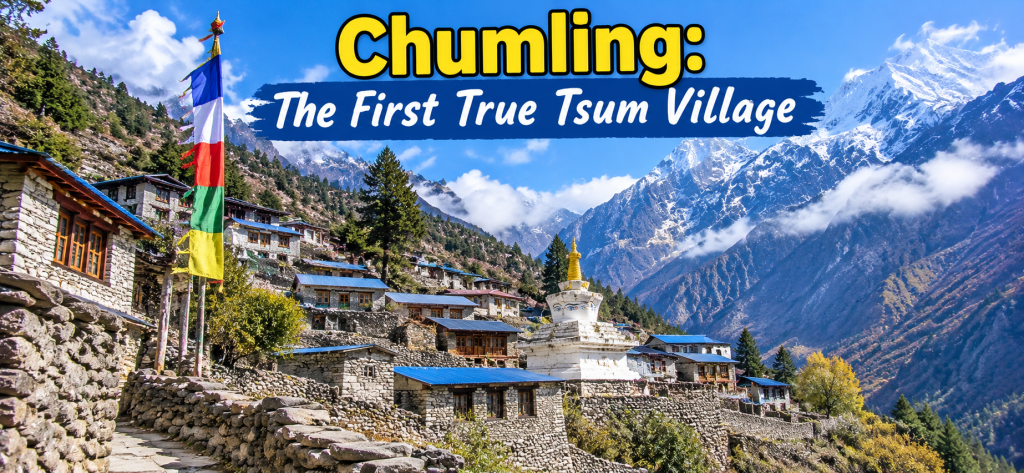
After Lokpa the trail drops and then climbs again, often through a stretch locals and some itineraries call Sardi Danda, a steep viewpoint climb that catches people off guard on a day they expected to be easier than the Lokpa ascent. Then it eases into Chumling, sitting at around 2,386 meters, a figure that is unusually consistent across the sources we checked, which is a small relief after the Lokpa confusion. Walking time from Lokpa is itself a small point of disagreement between sources, with one well established operator citing 4 to 5 hours and another breaking the same stretch into smaller segments that add up closer to 6 hours once you include the climb to the Sardi Danda viewpoint, so budget for the longer figure and treat anything faster as a pleasant surprise.
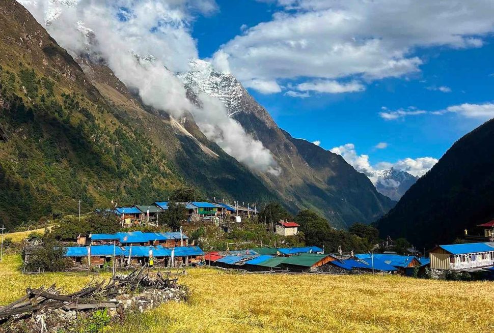
Chumling feels like the valley clearing its throat before the main performance. It has an old gompa above the village, slate roofed houses stacked against the hillside, and your first real views up toward Himal Chuli and the Boudha Himal if the afternoon clouds have not rolled in yet, which in the Tsum Valley they often have by early afternoon. The village runs on barley, potato and buckwheat farming, with animal pens built into the ground floors of houses the way you see throughout this part of the Himalaya.
Teahouses in Chumling are modest, usually family run, with simple menus built around dal bhat, noodle soup and eggs. Electricity comes from small solar setups and occasionally a micro hydro line, so do not expect reliable charging or hot showers as a given, though some lodges will heat a bucket of water for you if you ask. Wifi, where it exists at all this far up, is unreliable at best. This is also roughly where some itineraries place the first mention of the valley wide custom against killing animals for meat, something we will return to in more detail once we reach Mu Gompa, where the tradition is most often explained to trekkers.
Mornings in Chumling tend to start cold and clear, with the kind of still air that carries sound oddly far, a dog barking somewhere below the village, a prayer wheel creaking on its axle, someone splitting firewood before the mist burns off. By mid morning cloud often builds from the south and the big peaks disappear again, so if you want the photograph of Himal Chuli from Chumling, take it the moment you step outside rather than waiting for a better angle later in the day. That window closes fast up here.
Chhekampar and Chhokangparo: The Upper Valley’s Main Village
Here is a naming puzzle worth sorting out properly, because trekking companies use these two names almost interchangeably and it genuinely confuses first time visitors reading several brochures side by side. Chhekampar and Chhokangparo refer to the same general settlement cluster, the administrative center of upper Tsum, though the old Nepali village development committee records actually treat Chhaikampar (itself a slightly different spelling again) and Chhokangparo as separate committees covering overlapping ground. In plain terms for a trekker: you will see both names used for what is functionally one stop on the trail, a cluster of houses, a school, a health post and the largest concentration of lodges above Chumling, and you should not worry about which spelling is correct because nobody in the trekking industry has settled on one either.
Altitude is another place where the sources pull apart. Most trekking company itineraries we checked give a consistent figure around 3,030 to 3,031 meters. Wikipedia’s own entry for Chhokangparo, however, lists the village at 3,501 meters, which is a sizable and frankly surprising difference from what multiple independent guiding companies report for the same stop. We do not have a way to resolve that gap from here, so we are flagging it rather than averaging it away. Expect somewhere in the low to mid 3,000 meter range and treat the exact number as approximate.
Whatever the number, this is where the valley starts to feel properly Tibetan. Mani walls line the paths, prayer flags stretch between poles on the rooftops, and the Ganesh Himal comes into clear view on a good day, close enough that you can pick out individual rock bands on the ridgelines. Chhekampar and Chhokangparo together form the biggest concentration of teahouses in upper Tsum, so this is often used as a base for a short rest day, or as the jumping off point for the side trip to Gumba Lungdang, which we cover later in this guide. Rooms are simple but generally a step up from Lokpa or Chumling, with a bit more choice of lodges and slightly more reliable solar power. Many of the dining halls here are heated with a dung fired stove rather than wood, since wood is scarcer at this elevation, and the smell takes some getting used to on your first night.
Lamagaon, Milarepa’s Cave and Rachen Gompa
The stretch between Chhekampar and Nile is where most itineraries route trekkers past the two sites people actually came to Tsum to see: the cave associated with the Tibetan Buddhist saint Milarepa, and the nunnery at Rachen Gompa. Different companies sequence this differently. Some visit Lamagaon, the cave and Rachen Gompa on the way up to Nile, others save Rachen Gompa for the walk back down from Mu Gompa a couple of days later, passing through Chhule and Phurbe instead. Check your own itinerary rather than assuming, because the order genuinely varies between operators and it changes how your day is shaped.
Lamagaon itself (also written Lar Gaon in some older material) is a small hamlet with an aging village gompa that one researcher who has spent time documenting the valley’s monasteries described as the spiritual center of daily life there, separate from the larger institutions up the valley. It is easy to walk through without noticing it is there at all if your guide does not point it out.
The Cave of Milarepa
Milarepa was an eleventh century Tibetan yogi, probably the most famous figure in the entire Kagyu lineage of Tibetan Buddhism, known for a dramatic life story that moves from black magic and revenge in his youth to total renunciation and enlightenment under his teacher Marpa. Caves linked to his meditation retreats are scattered across the Tibetan Buddhist world, including a well known one near Nyalam in Tibet itself, and it is worth being careful not to confuse that one with the cave in Tsum, sometimes called Piren Phu, which is a separate site with its own local devotional history.
One source we found gives the Tsum cave’s altitude as roughly 4,100 meters, which struck us as odd given that it sits along a walking route between villages that mostly sit between 3,000 and 3,400 meters, and no trekking company itinerary we checked gave the cave a specific elevation figure at all. We suspect the 4,100 meter figure may be an error or may refer to a different nearby feature, and we were not able to independently confirm it, so treat any altitude claim for the cave itself with real caution. What is better documented, if still resting mainly on oral tradition rather than independent historical record, is the devotional content: local belief holds that Milarepa meditated here for an extended period without food or water, and that he eventually subdued a group of hostile spirits disturbing his retreat and converted them into protectors of the site. This is a matter of local religious tradition passed down through the valley’s lamas rather than something an outside historian has verified, and we present it here as exactly that, a belief held and recounted locally, not a settled historical fact.
Rachen Gompa
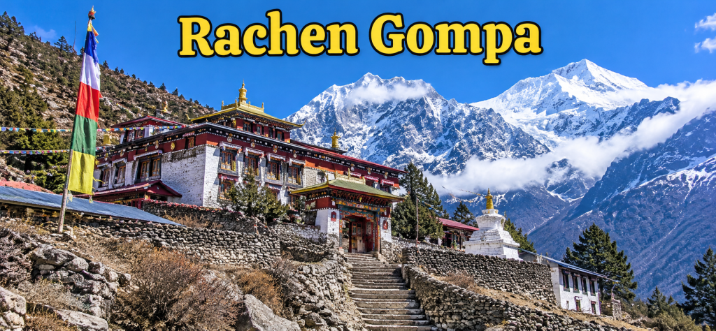
Rachen Gompa sits on a plateau at around 3,240 meters, a figure that appeared consistently across the sources we checked, which made a nice change. It is a nunnery, not a monastery in the sense of housing monks, and it is one of the two major religious institutions at the heart of the valley’s spiritual life, the other being Mu Gompa further up.
According to a detailed account published by a Buddhist studies outlet that visited and documented the site, Rachen Gompa was founded in 1936 by a Bhutanese lama referred to as Drupa Rinpoche, a name that, given the Bhutanese connection, likely points toward the Drukpa Kagyu lineage, though we did not find a source that states the sectarian affiliation in so many words. That same lama is credited with founding Mu Gompa as well. In 2005, according to the same account, the current holder of that title asked the well known teacher Lama Zopa Rinpoche to take responsibility for the welfare of both communities, which were struggling at the time, and Lama Zopa Rinpoche in turn brought in Kopan Monastery near Kathmandu to oversee their administration. A monk named Geshe Tenzin Nyima was later sent to lead Rachen after finishing his geshe degree, the senior scholarly qualification in the Tibetan monastic system.
Around three dozen nuns live and study at Rachen Gompa, ranging from young girls to elderly women, following a daily routine of prayer, study and ritual practice alongside basic secular schooling for the youngest residents. The original temple holds older paintings, texts and, by one account, hundreds of small clay votive offerings called tsa tsas depicting the bodhisattva of compassion. Restoration and heritage conservation work has been ongoing for years, including a large peace stupa that was under construction when the sources we reviewed were written, so it may well be finished, or further along, by the time you visit. Lodging near Rachen Gompa tends to be minimal, sometimes just a single simple guesthouse or the option to continue on to Nile for the night, so most itineraries treat it as a stop to visit rather than a place to sleep.
Nile: The Last Proper Village Before the High Valley
Nile sits at around 3,360 meters, another figure that held up reasonably well across the sources we checked, give or take ten meters depending on which operator’s brochure you read. This is generally treated as the last settlement in the valley with anything like a normal, year round village feel, with a handful of houses, small barley fields where the growing season allows it, and a cluster of teahouses that serve as the last real choice of lodging before the walk thins out toward Mu Gompa.
The walk into Nile, whether you are coming directly from Chhekampar or via Lamagaon and Rachen Gompa, tends to open the valley up visually. The peaks that were hinted at lower down become fuller, and the Tibetan plateau feels suddenly close, which it is. Nile is also usually the last point where trekking groups reliably get a hot shower or a slightly wider food menu before the altitude and the thinner population above start to simplify what the kitchens can offer.
Rooms here are simple stone or timber built lodges, cold at night even by the standards you have already gotten used to lower in the valley, and most lodges rely on quilts and extra blankets rather than any kind of heating in the bedrooms, saving the stove heat for the communal dining room. If you are doing this trek without your own four season sleeping bag, Nile is one of the nights where you will feel the gap most, so check the Tsum Valley packing list guide before you go rather than finding out the hard way at 3,360 meters.
Chhule and the Final Approach to Mu Gompa
Chhule is the kind of place that appears in almost every itinerary as a name you pass rather than a place you necessarily stop. It sits somewhere in the 3,350 to 3,400 meter range by rough estimate, since none of the sources we reviewed gave it a confident, specific altitude the way they did for Nile or Mu Gompa, and it is described more often as a scattering of houses close to the Tibetan border than as a formal village with its own facilities.
What makes Chhule worth noting is partly its position, close enough to the border that this stretch of the trek has a genuine frontier feel, and partly its seasonal character. Several accounts describe this part of the upper valley as very thinly populated in winter, when families who keep houses here move down to warmer villages, so do not expect much in the way of teahouse choice if you are trekking in the colder months. In the main trekking seasons there is usually at least a basic place to get tea and a simple meal, but this is not a stop to plan around for comfort. Most groups simply walk through on the way to Mu Gompa, using it as a landmark that tells you the end of the day’s climb is close.
Mu Gompa: The Highest Point of the Standard Trek
Mu Gompa is the turnaround point for most Tsum Valley itineraries and sits at roughly 3,700 meters, with a couple of sources putting it slightly higher, closer to 3,710 meters. It is consistently described as the largest and highest monastic institution in the valley, a three story stone building in traditional Tibetan style with whitewashed walls and gilded roof ornaments, standing almost at the head of the Shyar Khola drainage with nothing much above it but ridgelines leading toward the Tibetan plateau.
There is a naming wrinkle here too, worth being upfront about. Some material calls Mu Gompa itself Dhephyudonma Gompa, treating the two names as the same building. Other sources instead describe a separate, smaller nunnery about ten to fifteen minutes’ walk further up the hillside from Mu Gompa under that name, implying two distinct institutions rather than one building with two names. We were not able to fully resolve which version is correct, so if a guide or itinerary uses the Dhephyudonma name, ask whether they mean the main gompa you are standing in front of or the smaller building up the slope, because it genuinely seems to depend on who you ask.
What is inside
Mu Gompa functions as an active Shedra, a monastic school for scriptural study, alongside its role as a place of retreat. Conservation documentation on the building describes it as holding old Kangyur scriptures (one of the two main canonical collections of Tibetan Buddhist texts), wooden printing blocks used for producing religious texts by hand, painted thangkas and wall murals, and a statue of the bodhisattva of compassion that local tradition describes as roughly a century and a quarter old. That age comes from local and devotional telling rather than any independent dating we could verify, so we are presenting it as a claim the community makes about the statue, not as an established fact.
On the question of which specific school of Tibetan Buddhism the monastery belongs to, the sources genuinely conflict, and it would be dishonest to paper over that. A conservation document focused on Mu Gompa describes it as belonging to the Gelugpa, or Yellow Hat, tradition. Separately, the account that traces Mu Gompa’s founding back to the Bhutanese lama who also founded Rachen Gompa points, through that Bhutanese connection, toward the Drukpa Kagyu lineage instead, without using that term explicitly. Broader descriptions of Tsum Valley religious life tend to avoid naming a specific school at all, simply calling the valley’s practice Mahayana and Vajrayana Buddhism in the Tibetan tradition. Our honest read is that this is an area where popular trekking material has not been fully reconciled with more specialized religious scholarship, and a trekker should hear a guide’s explanation as local, informed opinion rather than a settled classification.
Teahouse lodging at Mu Gompa is the most basic you will find on the standard route, since this is effectively the end of permanent settlement going up the valley. Expect a handful of simple rooms attached to a guesthouse near the monastery, very limited choice if the lodge is full, cold nights even inside a heated building, and food options that thin out to little beyond dal bhat, instant noodles, eggs, tea and perhaps some tsampa if you ask nicely. Solar power is inconsistent and sometimes absent altogether on cloudy days, so bring a headlamp and spare batteries rather than counting on charging anything overnight.
The Valley’s Vow of Nonviolence
No honest guide to Tsum Valley villages can skip past the custom that visitors ask about more than almost anything else, which is the valley’s long standing commitment to nonviolence toward animals. This deserves a careful telling, because the popular version repeated in a lot of trekking marketing simplifies a more layered local history, and because most of what we found traces back to a small number of Nepali language news reports and a single international conservation network article, rather than a wide body of independent documentation.
According to Nepali press coverage of a related anniversary event, the pledge is dated locally to a Buddha Jayanti observance in the Nepali year 1977 BS, which corresponds to around 1920 in the Gregorian calendar, attributed to a religious figure referred to in that reporting as Avatari Lama Dukpa Lama Sarp Dorje, a name that reads more like an honorific and lineage title than a simple personal name, and we have not been able to independently verify it beyond that one source. Under this telling, the eleven settlements of what is called Upper Tsum made the original collective pledge, while the twenty two settlements of Lower Tsum are described as reaffirming or joining the commitment formally during a Shyagya festival reported around 2012, though the exact nature of that later event (a renewal versus a first adoption for Lower Tsum specifically) is not entirely clear from the reporting we reviewed.
The hundredth anniversary of the original pledge fell in the Nepali year 2077 BS, close to 2020 in the Gregorian calendar, but the planned centenary festival was disrupted by the COVID 19 pandemic and the celebration marking it was instead reported in Nepali media around 2023. A separate rural municipal government, Tsum Nubri Rural Municipality, has since published local measures intended to formally preserve the tradition, often referred to in reporting as a Shyagya Tradition Preservation ordinance, which functions as a local legal backing for the custom rather than as national Nepali law, a distinction worth keeping straight if you read other summaries that describe it more grandly.
In practical terms, the custom, locally called Shyagya, is described in reporting as covering a specific set of restrictions, which we list here as given rather than reworded into something broader than the sources actually support.
- Hunting of wild animals is forbidden throughout the pledged area.
- Setting traps for animals is forbidden.
- Harvesting wild honey is forbidden.
- Selling livestock for slaughter is forbidden.
- Harming the calves of Himalayan cattle, along with other land and water animals, is forbidden.
- Importing or exporting animals destined for meat is restricted, with the community expected to respect those restrictions.
- Burning of forest and mountain vegetation is banned.
What this means for you as a trekker is fairly direct. Lodges throughout much of the valley, by several accounts, serve no meat at all, which lines up with what most trekkers report eating in practice, mostly dal bhat, vegetable curries, eggs, instant noodles and the occasional potato dish cooked a dozen different ways. If you were hoping for the yak steak or buffalo momo you might get lower on the main Manaslu Circuit, Tsum is not that kind of valley, and most guides will explain why before you even ask.
Gumba Lungdang and the Ganesh Himal Side Trip
For trekkers with extra days, a guide comfortable with the route and a body that has acclimatized well, there is an optional branch from Chhekampar up to Gumba Lungdang, sometimes spelled Gumba Lundang, and from there onward toward Ganesh Himal Base Camp. This is not part of the standard village to village loop most people walk, and several of the operators we checked treat it as a genuinely separate add on itinerary requiring its own extra days, rather than a short detour you can tack onto an existing schedule without planning for it.
Gumba Lungdang itself sits at around 3,200 to 3,240 meters, with even a single detailed trip description we found giving two slightly different figures for the same day’s stop within its own itinerary, which tells you something about how loosely some of these higher, less visited altitudes get recorded. The monastery there is tucked at the base of a conical hill set against the main flank of the Ganesh Himal, described by the source that visited it as having a tranquil atmosphere, and it is genuinely remote even by Tsum standards, well off the route that most teahouse groups will ever walk.
From Gumba Lungdang, the push on to Ganesh Himal Base Camp, at roughly 4,200 meters, is reported as a long day, something in the range of seven to eight hours round trip with a return to sleep again at Gumba Lungdang, rewarded with close range views of the Ganesh Himal that you simply do not get from the main valley floor. This is a serious high altitude add on day, not a casual walk, and it should only be attempted with a guide who knows the terrain and with your acclimatization schedule already comfortably ahead of the altitude. Lodging at Gumba Lungdang is minimal, essentially one basic guesthouse setup near the monastery rather than a village with any real choice, so groups heading up this branch typically need to be fully self sufficient on food and gear in a way the main Nile to Mu Gompa stretch does not demand.
The Walk Back Down
Coming down from Mu Gompa, most itineraries either retrace the exact route through Nile, Chhekampar and Chumling back to Lokpa, or vary the order slightly by routing through Rachen Gompa, Chhule and Phurbe on the descent if the ascent skipped that stretch. Either way, the villages are the same ones you already met going up, just experienced the other direction and usually at a faster pace, since most of the technical acclimatization concerns are behind you and bodies tend to move quicker downhill once the oxygen starts coming back.
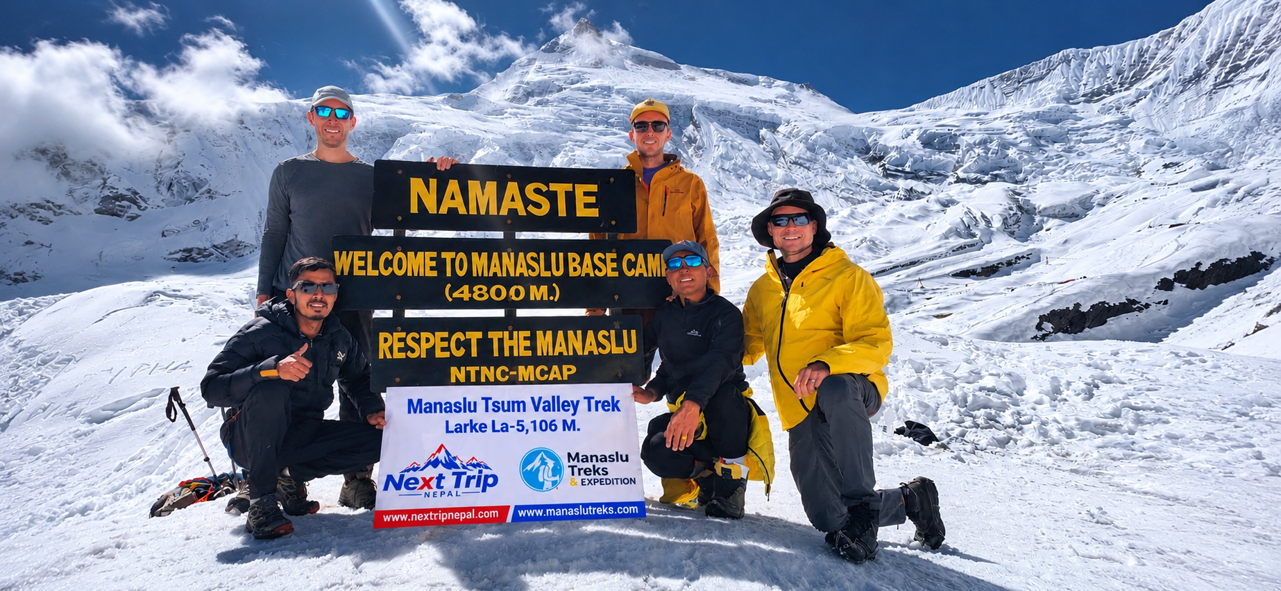
From Lokpa, trekkers doing the Tsum Valley as a standalone loop head back down to Philim and Jagat, then continue out through Dobhan, Tatopani and Machhakhola to Soti Khola or Arughat for the drive back to Kathmandu. Those combining the valley with the full Manaslu Circuit, commonly sold as the 19 day Manaslu Circuit with Tsum Valley Trek, instead rejoin the main trail near Lokpa or Jagat and continue north and east through Deng, Namrung, Lho, Shyala and Samagaun toward the Larkya La and on to the Annapurna side, turning what started as a side valley detour into roughly three weeks of walking in total. Either version works, and which one suits you depends mostly on how much time and how much high altitude appetite you are bringing to Nepal in the first place.
Teahouses, Food and Lodging Through the Valley
A few general patterns hold true across almost every stop described above, worth gathering here rather than scattering piecemeal. Lower in the valley, from Lokpa through Chumling and Chhekampar, you will find a genuine choice of lodges, simple attached bathrooms in some of the better rooms, intermittent but real solar electricity, and menus that, while limited compared to lower altitude parts of Nepal, still offer a handful of options beyond the absolute basics.
Above Chhekampar, at Nile, Chhule and Mu Gompa, the picture narrows considerably. Expect fewer lodges overall, sometimes only one realistic option in the smaller stops, colder rooms with minimal insulation, inconsistent power that can disappear entirely for a day or two if the weather turns, and kitchens that lean almost entirely on dal bhat, instant noodles, potatoes and eggs, with little in the way of meat anywhere thanks to the valley’s nonviolence custom described above. Hot showers become less reliable the higher you climb, and a good number of trekkers simply skip washing properly for the two or three nights above Chhekampar rather than fight with a bucket of lukewarm water in a cold room.
Wifi exists in pockets lower in the valley, usually for a small fee and usually slow, and becomes essentially nonexistent above Nile. Phone signal follows a similar pattern, present in patches near the larger villages and gone for long stretches in between. None of this should put you off. It simply means Tsum rewards trekkers who pack properly and arrive with realistic expectations rather than those hoping for the comfort level of the busier teahouse routes elsewhere in Nepal.
Planning Your Own Village by Village Itinerary
Most trekkers walk the Tsum Valley over somewhere between seven and ten walking days once you count the approach from Soti Khola or Arughat and the return, though exact day counts vary a fair amount between operators depending on how many rest and acclimatization days they build in around Chhekampar and Nile.
The route described in this guide, Lokpa to Chumling to Chhekampar and Chhokangparo, out to Lamagaon, Milarepa’s Cave and Rachen Gompa, up through Nile and Chhule to Mu Gompa, with the Gumba Lungdang and Ganesh Himal branch available for those with extra time, covers every stop that shows up consistently across the sources we checked for this piece.
If you are choosing between a standalone Tsum Valley loop and combining it with the wider Manaslu Circuit, it helps to read up on the valley’s history and culture in more depth before you commit to either, since the restricted permit requirements, minimum group sizes and guide arrangements that apply to Tsum are a bit different from the rules governing the main Manaslu Conservation Area trail alone. It is also worth going through a proper Tsum Valley packing list and the month by month weather notes for the region before you travel, since the gap between a comfortable night in Chumling and a genuinely cold one in Mu Gompa is almost entirely a function of what you packed, not luck. Whatever combination of villages and side trips you settle on, this is still one of the quieter, more culturally intact corners of the Nepal Himalaya left to trek through, and walking it slowly, village by village, is the whole point.
Related Manaslu and Tsum Valley Guides
If you are planning the Tsum Valley Trek, a few other guides on this site go deeper into specific parts of the trip. Money, SIM Cards and Staying Connected on the Manaslu Circuit Trek covers cash, connectivity and WiFi for the wider Budi Gandaki region that Tsum Valley shares. If you are tempted by something even more remote once you reach the upper valley, The Rupina La Pass looks at the rarely trekked route connecting this area to the Ganesh Himal. For logistics before you go, see the Tsum Valley packing list and the history and culture of Manaslu Tsum Valley guides.