| Category | Detail |
|---|---|
| Region | Gorkha District, west-central Nepal (Mansiri Himal range) |
| Trek Type | Tea-house / lodge-to-lodge circuit trek |
| Highest Point | Larkya La Pass — 5,106 m to 5,160 m (figures vary slightly by source/GPS) |
| Trek Duration | 10–18 days (14 days most common) |
| Total Distance | Approximately 150–180 km depending on start/end points and side trips |
| Trek Difficulty | Moderate to challenging |
| Starting Point | Soti Khola or Machha Khola (via road from Kathmandu/Arughat) |
| Ending Point | Dharapani / Besisahar (Annapurna region) |
| Permits Required | Restricted Area Permit (RAP), Manaslu Conservation Area Permit (MCAP), Annapurna Conservation Area Permit (ACAP), Chumnubri Rural Municipality Permit |
| Guide Requirement | Mandatory, licensed guide through a registered trekking agency |
| Best Seasons | Spring (March–May) and Autumn (September–November) |
| Average Cost | USD 1,100–2,800 per person depending on group size, season, and service level |
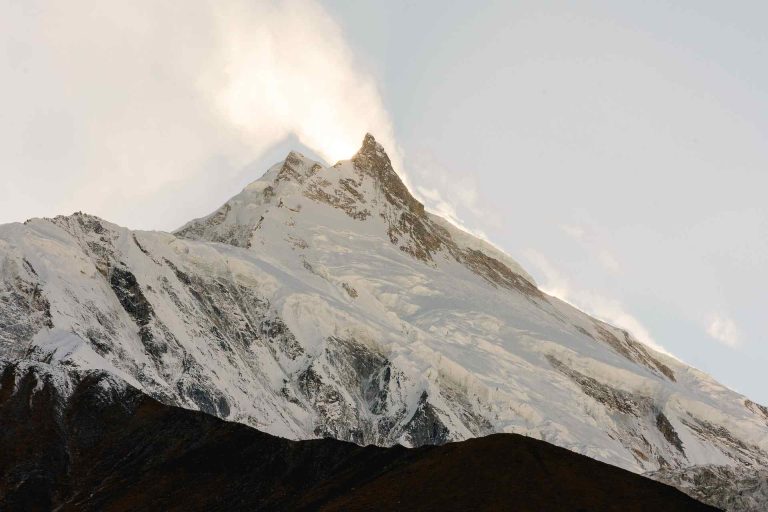
| Highest Mountain Visible | Mount Manaslu — 8,163 m, the world’s 8th-highest peak |
| Conservation Area | Manaslu Conservation Area (MCA) — 1,663 sq. km, established 1998 |
| Famous Side Trip | Tsum Valley (“Hidden Valley”) |
| Accommodation | Basic teahouses/lodges; camping in select upper sections |
| Currency Needed | Nepali Rupees (cash; no ATMs beyond Machha Khola/Jagat) |
Table of Contents
1. Introduction to the Manaslu Circuit Trek
The Manaslu Circuit Trek is one of the last great wilderness walks in the Nepal Himalaya, a multi-day journey that loops entirely around Mount Manaslu, the eighth-highest mountain on Earth at 8,163 meters. Unlike the Everest and Annapurna regions, which now see hundreds of thousands of visitors every year, the Manaslu region remained legally closed to foreign trekkers until 1991. That late opening, combined with its ongoing status as a government-restricted area, has preserved something increasingly rare in Nepal: a trekking route where teahouses are still family-run rather than corporate, where villages function on subsistence farming and yak herding rather than tourism alone, and where a day on the trail might pass with only a handful of other foreigners in sight. Contact our manaslu trekking company to plan your trip with local experts.
Geographically, the trek begins in the warm, terraced lowlands of the Gorkha District and climbs steadily north along the Budhi Gandaki River gorge, through forests of sal and rhododendron, into high alpine villages shaped by Tibetan Buddhist culture, and finally over the dramatic Larkya La Pass before descending into the Annapurna region near Dharapani. In the space of roughly two weeks, trekkers pass through six distinct climatic and cultural zones from subtropical jungle at 600 meters to high alpine desert above 5,000 meters — making it one of the most ecologically and culturally diverse treks anywhere in the worldWhat sets the Manaslu Circuit apart from nearly every other major trek in Nepal is the legal framework around it. Because the region sits along a sensitive stretch of the Tibet (China) border and is classified as a Restricted Area, independent trekking is not permitted. Every foreign visitor must travel with a government-licensed guide arranged through a registered Nepali trekking agency, carry a Restricted Area Permit, and (until a 2026 policy change discussed later in this guide) historically needed to be part of a minimum group of two. This regulation is precisely why the region has stayed so well preserved — the same bureaucratic friction that makes planning slightly more complex than, say, the Annapurna Circuit is also what has kept the Manaslu region’s monasteries, forests, and village life intact.
This guide is built to be the single most complete resource on the Manaslu Circuit Trek available — covering every fact, figure, cost, itinerary option, cultural detail, and safety consideration a trekker could need before committing to this extraordinary journey around the “Mountain of the Spirit.”
2. About Mount Manaslu — The Mountain Behind the Trek
Basic Facts
Mount Manaslu rises to 8,163 meters (26,781 feet), making it the eighth-highest mountain in the world and the highest peak located entirely within a single Nepali district, Gorkha. It sits within the Mansiri Himal, a subrange of the greater Himalaya, roughly midway between the Annapurna massif to the west and the Langtang/Ganesh Himal ranges to the east. The mountain’s name derives from the Sanskrit word manasa, meaning “intellect” or “soul” — earning it the poetic nickname “Mountain of the Spirit.” Local Tibetan-descended communities in the Nubri Valley regard the peak with deep religious reverence, viewing it as the seat of protective deities rather than simply a geological feature.
Despite this serene name, Manaslu carries one of the more sobering nicknames in mountaineering: the “Killer Mountain.” This label is not about the technical climbing difficulty (Manaslu is generally considered less technically demanding than neighbors like Annapurna or K2) but about its avalanche history. The mountain’s slopes are particularly prone to large, unpredictable avalanches, and several expeditions over the decades have suffered devastating losses, including a catastrophic avalanche in 1972 that killed members of a Korean expedition team and their Nepali support staff at a camp around 6,500 meters.
Mountaineering History
- 1950: British explorer H.W. Tilman, during a reconnaissance of the wider Annapurna massif, was among the first Westerners to survey Manaslu and judge a summit route possible.
- Early 1950s: Japanese expeditions made several reconnaissance and summit attempts, facing severe weather, avalanche danger, and at one point local opposition that blocked an attempt.
- May 9, 1956: Toshio Imanishi (Japan) and Gyalzen Norbu (Nepal), part of a Japanese expedition, completed the first confirmed ascent of Manaslu — a milestone in Himalayan mountaineering history, achieved just three years after the first ascent of Everest.
- 1972: Reinhold Messner completed a solo climb of Manaslu’s notoriously difficult southwest face, a feat still regarded as one of the boldest solo climbs of the era.
- 1974: A Japanese women’s team led by Kyoko Sato became the first all-female team to summit an 8,000-meter peak, doing so on Manaslu.
- 1984: Polish climbers Maciej Berbeka and Ryszard Gajewski achieved the first winter ascent of Manaslu, summiting in temperatures reportedly near -30°C.
- Present day: Manaslu has become one of the most popular 8,000-meter peaks for commercial expeditions, in part because it is viewed as a relatively approachable “first 8,000er” for climbers preparing for Everest. Several thousand summits have now been recorded, alongside roughly 90 confirmed climbing fatalities since 1956 — a fatality rate that places Manaslu among the more dangerous of the fourteen 8,000-meter peaks, primarily due to avalanche risk rather than technical climbing difficulty.
Notable Peaks Visible Along the Trek
Trekkers on the Manaslu Circuit are rewarded with views of an extraordinary concentration of high peaks, including:
| Peak | Approximate Elevation |
|---|---|
| Mount Manaslu | 8,163 m |
| Himalchuli | 7,893 m |
| Ngadi Chuli (Peak 29) | 7,871 m |
| Cheo Himal | 6,820 m |
| Manaslu North | 7,157 m |
| Larkya Peak | 6,249 m |
| Naike Peak | 6,211 m |
| Samdo Peak | 5,177 m |
| Ganesh Himal | 7,422 m (visible on clear days from lower sections) |
| Himlung Himal | 7,126 m (visible near Larkya La) |
This concentration of giant peaks within view of a single trekking route is part of why Manaslu is increasingly described as one of the most visually dramatic circuits in Nepal — arguably rivaling, and in the eyes of many seasoned trekkers surpassing, the more famous Annapurna Circuit.
3. History of the Manaslu Region and Trekking Route
For most of the twentieth century, the valleys around Mount Manaslu were entirely closed to foreign travelers. Nepal itself only opened to outside visitors in the 1950s, and even after popular routes like the Everest and Annapurna regions began welcoming trekkers through the 1960s–1980s, the Manaslu region — sitting close to the sensitive Tibetan border — remained under tight government control.
The turning point came in 1991, when the Nepali government formally opened the Manaslu region to foreign trekkers under a Restricted Area Permit system. This was a deliberate policy choice rather than an oversight: by limiting numbers, requiring registered guides, and channeling permit revenue into conservation, the government aimed to avoid the rapid, sometimes uncontrolled commercialization that had already reshaped parts of the Annapurna and Everest trails.
In 1998, seven years after the trekking route opened, Nepal’s Department of National Parks and Wildlife Conservation, in partnership with the National Trust for Nature Conservation (NTNC), formally declared the Manaslu Conservation Area (MCA) — a 1,663-square-kilometer protected zone encompassing the entire trekking circuit. The MCA became NTNC’s second managed conservation area after the larger Annapurna Conservation Area, and its creation tied trekking permit fees directly to local conservation and community development projects, a model that continues today.
The neighboring Tsum Valley followed an even slower path to opening. While the Nubri Valley (the main Manaslu Circuit route) had limited outside contact going back to around 1950, the Tsum Valley remained almost entirely sealed off until 2008, when it was finally opened as a separate, even more tightly restricted permit area. This nearly six-decade-long isolation is precisely why Tsum Valley is often described today as one of the most untouched Tibetan Buddhist cultural landscapes left in the Himalaya.
This history matters for modern trekkers because it explains almost everything distinctive about the experience: the relatively low number of trekkers compared to Everest or Annapurna, the requirement for a licensed guide, the patchwork of permits, and the unusually well-preserved monasteries, festivals, and village architecture that line the route. The Manaslu Circuit is, in a very real sense, what the Annapurna Circuit looked like several decades ago — and Nepal’s restricted-area policy is the reason it has stayed that way.
4. Why Trek the Manaslu Circuit — Key Highlights
A Genuine Wilderness Experience
Compared to the Everest and Annapurna regions, the Manaslu Circuit sees a fraction of the foot traffic. Trekkers frequently describe entire trail sections where they encounter no other foreign visitors for hours. The infrastructure is more basic by design — fewer bakeries, fewer Wi-Fi-equipped lodges, fewer souvenir shops — and that scarcity is exactly what gives the trek its strong sense of genuine adventure.
Dramatic and Varied Landscapes
In the space of roughly 150–180 kilometers, the trail moves through:
- Lush, terraced rice paddies and subtropical forest in the lower Budhi Gandaki valley
- Deep, dramatic river gorges carved by glacial meltwater
- Dense rhododendron, pine, and oak forests in the mid-hills
- High alpine villages built in Tibetan style, with flat roofs and prayer-flag-strewn rooftops
- Glacial lakes (Birendra Tal near Samagaon, Ponkar Lake near Bimthang)
- Dry, high-altitude desert terrain around Samdo, reminiscent of the Tibetan plateau
- The dramatic glaciated approach to Larkya La Pass itself
Cultural Immersion
The upper Nubri and Tsum valleys are home to communities of Tibetan descent who maintain Nyingma Buddhist traditions, ancient monasteries, mani walls, chortens, and festivals largely unchanged for centuries. Trekkers pass directly through villages where everyday life — farming, herding, weaving, prayer — continues much as it has for generations, offering a level of cultural access rarely found on more commercialized routes.
A Less Crowded Alternative to Annapurna
The Manaslu Circuit physically connects to the Annapurna Circuit near Dharapani, and many of the high-altitude landscapes — glacial valleys, high passes, mani walls — feel similar in character. The crucial difference is crowd density: where Annapurna’s Thorong La Pass can see long queues of trekkers during peak season, Larkya La Pass typically sees a comparatively small, steady trickle.
The Crossing of Larkya La Pass
The trek’s undisputed centerpiece is the crossing of Larkya La Pass at roughly 5,106–5,160 meters (sources vary slightly depending on GPS measurement point), which rewards trekkers with panoramic views of Himlung Himal, Cheo Himal, Kang Guru, and Annapurna II in a single sweeping vista.
Rare Wildlife and Biodiversity
The Manaslu Conservation Area is one of the Himalaya’s significant biodiversity hotspots, sheltering snow leopards, red pandas, Himalayan tahr, musk deer, and over 110 recorded bird species across eleven distinct forest types.
Side Trips Worth the Extra Days
- Tsum Valley: A sacred side valley with some of the best-preserved Tibetan Buddhist culture in Nepal.
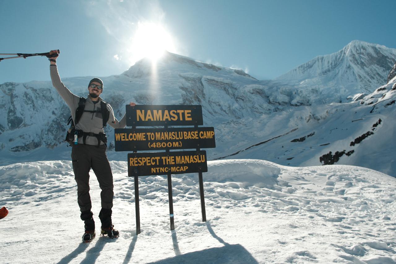
- Manaslu Base Camp: A day hike from Samagaon to the foot of the mountain itself, around 4,400–4,800 meters.
- Pungyen Gompa: A roughly 250-year-old monastery accessible on a side trail from Samagaon.
- Birendra Lake: A striking glacial lake a short walk from Samagaon.
5. Geography and Route Overview
The Manaslu Circuit Trek follows the Budhi Gandaki River upstream from the lowlands of the Gorkha District, circles around the northern and western flanks of Mount Manaslu, crosses Larkya La Pass, and descends into the Marsyangdi Valley to connect with the Annapurna Circuit trail near Dharapani. The route sits almost entirely within the Manaslu Conservation Area and briefly enters the Annapurna Conservation Area near its end.
Climatic and Ecological Zones
Because the trek spans an elevation range from roughly 600–700 meters at its lowest trailhead point to over 5,100 meters at Larkya La, it passes through an unusually compressed sequence of ecological zones:
| Zone | Approximate Elevation | Characteristics |
|---|---|---|
| Subtropical | 600–1,000 m | Sal forest, terraced farmland, banana and citrus groves |
| Lower temperate | 1,000–2,000 m | Mixed broadleaf forest, village agriculture |
| Upper temperate | 2,000–3,000 m | Oak, pine, and rhododendron forest |
| Subalpine | 3,000–4,000 m | Birch, juniper, dwarf rhododendron scrub |
| Alpine | 4,000–5,000 m | Alpine meadow, grazing pasture, sparse scrub |
| Trans-Himalayan / high alpine desert | 5,000 m+ | Rock, scree, glacier, minimal vegetation |
Major Settlements Along the Route
| Village | Approx. Elevation | Notable Feature |
|---|---|---|
| Soti Khola / Machha Khola | 600–900 m | Common starting trailhead |
| Jagat | 1,340 m | First major permit checkpoint |
| Deng | 1,800–1,860 m | Entry into deeper Nubri culture |
| Namrung | 2,630–2,660 m | Army/police checkpoint, last large village before high Nubri |
| Lho | 3,180 m | Famous monastery and first close-up Manaslu views |
| Shyala | 3,520 m | Dramatic amphitheater of peaks |
| Samagaon (Sama Gaon) | 3,520–3,530 m | Main acclimatization hub, access to Manaslu Base Camp |
| Samdo | 3,860–3,875 m | Last village, Tibetan trade history |
| Dharamsala (Larkya Phedi) | 4,460 m | Final staging point before the pass |
| Larkya La Pass | 5,106–5,213 m (sources vary) | Trek’s highest point |
| Bimthang | 3,590–3,720 m | First village after the pass, glacier views |
| Tilije / Dharapani | 1,920–2,300 m | Junction with the Annapurna Circuit trail |
Rivers and Glaciers
The trek’s lower and middle sections trace the Budhi Gandaki River, a glacially fed tributary of the larger Trishuli/Narayani river system, known for its dramatic gorges and suspension bridge crossings. Near Larkya La, trekkers pass close to the Manaslu Glacier — one of the largest in the region — as well as smaller glacial systems feeding into Birendra Tal and Ponkar Lake.
6. Manaslu Circuit Trek Permits and Cost (2026)
Because the Manaslu region is legally classified as a Restricted Area, trekkers cannot simply arrive in Kathmandu and start walking the way they could on the Annapurna or Everest trails. Every foreign trekker needs a stack of permits processed through a registered Nepali trekking agency before reaching the first checkpoint at Jagat.
The Four (or Five) Permits You Need
| Permit | Purpose | Where Checked |
|---|---|---|
| Manaslu Restricted Area Permit (RAP) | Main permit for the restricted zone between Jagat and roughly Dharapani | Jagat checkpoint, plus spot checks en route |
| Manaslu Conservation Area Permit (MCAP) | Entry into the Manaslu Conservation Area | Filim/Jagat area |
| Annapurna Conservation Area Permit (ACAP) | Required once the trail exits Manaslu and enters the Annapurna Conservation Area near Dharapani | Dharapani checkpoint |
| Chumnubri Rural Municipality Permit (CRMP) | Local municipal permit supporting community development | Local checkpoint within Chumnubri |
| Tsum Valley Permit (optional add-on) | Required only if extending into Tsum Valley | Lokpa/Chumling checkpoint |
A TIMS card, required on many other Nepal treks, is not required for the Manaslu Circuit — agencies that try to charge you for one on this route are simply padding their fees.
Manaslu Restricted Area Permit (RAP) Cost
This is the most expensive and the only date-sensitive permit. Pricing is split by season:
| Season | Months | First 7 Days | Each Additional Day |
|---|---|---|---|
| Peak (Autumn) | September–November | USD 100 per person | USD 15 per person/day |
| Off-Peak (Winter, Spring, Summer) | December–August | USD 75 per person | USD 10 per person/day |
MCAP and ACAP Fees (Fixed, Not Seasonal)
| Permit | Foreigners (Non-SAARC) | SAARC Nationals |
|---|---|---|
| MCAP | NPR 3,000 (~USD 22–25) | NPR 1,000 |
| ACAP | NPR 3,000 (~USD 22–25) | NPR 1,000 |
Tsum Valley Permit (If Added)
| Season | Cost (first week) | Additional Day |
|---|---|---|
| Autumn (peak) | Approx. USD 35–40 | Additional fee per day applies |
| Off-peak | Approx. USD 30–35 | Additional fee per day applies |
Estimated Total Permit Cost for a Standard 12–14 Day Trek
| Season | Approximate Total Permit Cost (per person) |
|---|---|
| Autumn (Sept–Nov) | USD 250–260 |
| Spring (Mar–May) | USD 190–200 |
| Winter/Summer (off-peak) | USD 145–175 |
These figures combine the variable-cost RAP with the fixed MCAP and ACAP fees, and include the government’s standard VAT/tax additions, which are usually bundled into agency quotes.
How Permits Are Obtained
- You cannot apply for Manaslu permits independently — only a trekking agency registered with the Trekking Agencies’ Association of Nepal (TAAN) can submit the paperwork to Nepal’s Department of Immigration.
- Your agency will need a clear scan of your passport (valid 6+ months), a copy of your Nepal tourist visa, passport-sized photos, and proof of travel insurance covering high-altitude emergency evacuation (often required to specifically cover rescue up to 6,000 m).
- Processing typically takes 1–2 business days in normal periods, but can stretch to 3–4 days during the busy October window.
- Your original passport (with the physical visa sticker) is required for the Department of Immigration to issue the permit, which is why agencies usually collect passports on your first or second day in Kathmandu.
Important 2026 Update on Solo Trekking Rules
For years, the defining rule of the Manaslu Circuit was that the Restricted Area Permit could only be issued to a minimum of two foreign trekkers traveling together, which made truly independent (single-traveler) trekking impossible — solo travelers had to be grouped with at least one other trekker by their agency purely for permit purposes.
According to several 2026 trekking-industry sources, Nepal’s Department of Immigration has revised this rule, allowing solo trekkers to obtain the Restricted Area Permit individually, without needing to be matched with a second trekker. However — and this is critical — a licensed guide remains mandatory regardless of this change, and the Manaslu region is still legally a Restricted Area requiring agency-issued permits. In other words, the minimum group size requirement appears to be loosening, but unguided, fully independent trekking is still not permitted. Because permit rules in restricted areas can and do shift from season to season, always verify the current requirement directly with a registered Nepali trekking agency or Nepal’s Department of Immigration before finalizing your trip — do not rely solely on any single blog post (including this one) for the very latest legal requirement on your travel dates.
7. Total Trip Cost Breakdown
Permit fees are only one slice of the total Manaslu Circuit Trek budget. Here is a fuller breakdown based on current 2026 agency pricing patterns.
Cost by Service Tier (12–14 Day Trek, Group Basis)
| Tier | Approx. Cost Per Person | What’s Typically Included |
|---|---|---|
| Budget / Group-Joining | USD 1,100–1,500 | Shared guide, basic teahouse lodging, all permits, breakfast/lunch/dinner on trek, group transport |
| Standard | USD 1,500–2,000 | Slightly smaller groups, better-vetted teahouses, dedicated porter option, more comfortable transport |
| Comfort / Private | USD 2,000–2,800+ | Private guide and porter, flexible pacing, upgraded teahouse rooms where available, private jeep transport |
| Luxury / Fully Customized | USD 3,000–4,500+ | Private vehicles throughout, top-tier available lodges, maximum flexibility, sometimes a personal cook |
Solo trekkers booking outside an existing group can expect to pay roughly 30–50% more than the per-person group rate, since fixed costs like the guide’s daily wage and permit processing are not being split among several trekkers.
Itemized Cost Components
| Cost Item | Approximate Range (per person, 12–14 days) |
|---|---|
| Permits (RAP + MCAP + ACAP + CRMP) | USD 145–260 (season-dependent) |
| Licensed guide | USD 350–560 (USD 25–40/day) |
| Porter (optional but recommended) | USD 200–350 (USD 15–25/day) |
| Teahouse accommodation | Often USD 2–5/night if you order meals there; sometimes free with meal purchase |
| Meals (breakfast, lunch, dinner) | USD 20–30/day at lower elevation; USD 25–35+/day at higher elevation |
| Kathmandu–Soti Khola/Machha Khola transport | USD 15–25 (public bus) to USD 150–250 (private jeep, one-way) |
| Return transport (Dharapani/Besisahar–Kathmandu) | USD 15–30 (public) to USD 150+ (private jeep) |
| Kathmandu hotel (pre/post trek) | USD 15–60/night depending on standard |
| Travel insurance (with helicopter evacuation) | USD 80–200 for the trip duration |
| Tips for guide/porter | USD 100–250 total (customary, not mandatory) |
| Gear rental (if needed) | USD 1–3/day per item (sleeping bag, down jacket, poles) |
Why Manaslu Costs What It Does
Three main factors drive the total cost up or down:
- Group size. Group treks split the fixed cost of guides and ground transport across more people, lowering the per-person price. Private treks cost more but offer greater flexibility in scheduling.
- Season. Autumn carries the highest permit fees (an additional USD 20–25 per person compared with spring) and the highest demand for teahouse beds and guides, which can further push prices up.
- Trip length. Each additional day adds roughly USD 100–150 to combined permit, food, lodging, and staff costs — but extra acclimatization days are among the best investments you can make for both safety and enjoyment.
Money on the Trail
There are no ATMs beyond the lower trailhead villages (Arughat/Soti Khola/Machha Khola), and very limited card payment acceptance anywhere on the route. Trekkers should carry sufficient Nepali Rupees in cash for the entire trek, including a buffer for tea, snacks, hot showers, device charging, Wi-Fi access (often charged per use in upper villages), and tips.
8. Best Time to Visit — Month-by-Month Weather Guide
The Manaslu region experiences four broad seasons, and — because the trail crosses six climatic zones — the weather you’ll feel can shift dramatically within a single day’s walk. As a general rule, spring (March–May) and autumn (September–November) are the two recommended trekking windows, with autumn (especially October) considered the single most reliable month for stable weather and clear mountain views.
Month-by-Month Overview
| Month | Season | Lower-Altitude Daytime Temp | Upper-Altitude / Pass-Area Temp | Conditions & Notes |
|---|---|---|---|---|
| January | Winter | -2°C to 6°C | -15°C to -20°C (night) | Coldest month; heavy snow likely at the pass; some teahouses closed; very low trekker numbers |
| February | Winter | 0°C to 8°C | -10°C to -15°C | Still cold and quiet; doable for experienced, well-equipped trekkers |
| March | Early Spring | 10°C to 18°C | 0°C to -10°C near the pass | Trekking season begins; occasional snow/rain; rhododendrons start blooming lower down |
| April | Peak Spring | 20°C to 31°C (lower valleys) | 5°C to 12°C nights | Most stable spring month; rhododendrons in full bloom; busy trails; book teahouses ahead |
| May | Late Spring | 15°C to 25°C | 5°C to 6°C day, down to -8°C night at altitude | Warm and stable lower down; afternoon cloud build-up possible; good visibility most days |
| June | Early Monsoon | 18°C–24°C | 8°C–15°C | Rain increasing; greenery flourishing; trails start to get muddy |
| July | Monsoon | 20°C–25°C+ | Variable, wetter | Heavy daily rain, leeches in lower forest, landslide risk; not recommended for most trekkers |
| August | Late Monsoon | 18°C–22°C | Variable | Rain still frequent but tapering toward month’s end; lush green landscapes |
| September | Early Autumn | 15°C–21°C | 8°C–15°C | Monsoon clearing; early month can be damp, later weeks turn clear and dry |
| October | Peak Autumn | 10°C–20°C | -2°C to 5°C | The most popular and most reliable month; crystal-clear skies; busiest trail traffic |
| November | Late Autumn | 5°C–15°C | -10°C to -2°C | Excellent visibility, colder nights; crowds thinning; still a top recommendation |
| December | Early Winter | 5°C–10°C | -8°C to 2°C | Dry, clear, very quiet trail; some lodges start closing at altitude |
Spring (March–May): Color and Stability
Spring is the season most associated with blooming rhododendron forests in the lower and mid-elevation sections of the trek, alongside generally stable weather and good Himalayan visibility. April is typically singled out as the most reliable spring month, with the most stable skies and longest daylight hours. This is also when Mount Manaslu’s own climbing season is active, so trekkers occasionally cross paths with expedition teams headed to base camp.
Autumn (September–November): The Gold Standard
Autumn is widely considered the single best trekking season in the Himalaya generally, and Manaslu is no exception. Once the monsoon clears (typically by mid-to-late September), the air is washed clean of dust and haze, delivering the sharpest, most consistent mountain views of the year. October in particular is often described by experienced guides as the “safe choice” for first-time high-altitude trekkers — the most teahouses are open, the most support infrastructure is available, and weather variability is at its lowest. The trade-off is that this is also peak season for crowds (relative to Manaslu’s normally quiet trails) and the most expensive permit window.
Winter (December–February): Solitude at a Cost
Winter brings extremely low trekker numbers and crisp, clear skies, but also serious cold — overnight temperatures near Larkya La can fall well below -15°C, and snow accumulation can render the pass genuinely dangerous or impassable without proper winter mountaineering gear (crampons, sometimes even rope work). Several teahouses at higher elevation close for the season due to lack of demand and harsh conditions. Winter trekking should be reserved for experienced, well-equipped trekkers traveling with guides who have direct experience reading the pass conditions at that time of year.
Monsoon (June–August): Generally Not Recommended
The monsoon months bring daily rainfall, slippery and muddy trails, active leeches in the lower forested sections, and a meaningfully elevated landslide risk along the narrow Budhi Gandaki gorge trail. Mountain views are frequently obscured by cloud. The main upside is dramatically lush scenery and a near-total absence of other trekkers — but most operators and experienced guides advise against attempting the full circuit, and especially the Larkya La crossing, during this period.
Shoulder Months Worth Considering
Early September and early December often get overlooked but can offer an excellent balance: reduced crowds, lower lodging pressure, and — particularly in early December — exceptionally clear, dry conditions before the deep winter cold sets in.
9. Detailed Day-by-Day Itinerary
There is no single “official” Manaslu Circuit itinerary — exact day counts vary depending on your starting trailhead (Soti Khola vs. the slightly more advanced Machha Khola), how many acclimatization or side-trip days you build in, and whether you extend into Tsum Valley. Below is a comprehensive 16-day itinerary (including arrival/departure and one extra acclimatization day at Samagaon), followed by guidance on shorter and longer variations.
Itinerary Overview Table
| Day | Route | Approx. Distance/Time | Max Altitude |
|---|---|---|---|
| 1 | Arrival in Kathmandu | — | 1,400 m |
| 2 | Permit processing & trek preparation in Kathmandu | — | 1,400 m |
| 3 | Drive Kathmandu → Soti Khola | 7–9 hrs drive | 700 m |
| 4 | Soti Khola → Machha Khola | 6–7 hrs walk | 869 m |
| 5 | Machha Khola → Jagat | 6–7 hrs walk | 1,340 m |
| 6 | Jagat → Deng | 6–7 hrs walk | 1,860 m |
| 7 | Deng → Namrung | 5–6 hrs walk | 2,630 m |
| 8 | Namrung → Lho | 3–4 hrs walk | 3,180 m |
| 9 | Lho → Samagaon | 3–4 hrs walk | 3,530 m |
| 10 | Acclimatization day in Samagaon (Base Camp/Pungyen Gompa side trip) | 4–6 hrs (optional hike) | 3,530–4,800 m |
| 11 | Samagaon → Samdo | 3–4 hrs walk | 3,860 m |
| 12 | Samdo → Dharamsala (Larkya Phedi) | 3–4 hrs walk | 4,460 m |
| 13 | Dharamsala → Larkya La Pass → Bimthang | 8–10 hrs walk | 5,106–5,160 m (pass) |
| 14 | Bimthang → Tilije/Dharapani | 5–7 hrs walk | 1,920–2,300 m |
| 15 | Drive Dharapani/Besisahar → Kathmandu | 8–9 hrs drive | 1,400 m |
| 16 | Departure / extra day in Kathmandu | — | — |
Day-by-Day Narrative
Day 1 — Arrival in Kathmandu. Most trekkers fly into Tribhuvan International Airport and transfer to a hotel, usually in the Thamel tourist district. This day is normally reserved for rest after international travel and an introductory briefing with the trekking agency.
Day 2 — Permit Processing and Final Preparations. Because Manaslu permits cannot be obtained on the spot, your agency uses this day to submit your passport and documents to the Department of Immigration. Most trekkers use the free time to rent or buy any last-minute gear in Thamel, visit a UNESCO site like Swayambhunath or Boudhanath, or simply rest.
Day 3 — Drive from Kathmandu to Soti Khola. A long but scenic 7–9 hour drive (longer if road conditions are poor) follows the Prithvi Highway before turning north toward Arughat and then Soti Khola, gaining views of terraced hillsides and the Budhi Gandaki valley opening up ahead.
Day 4 — Soti Khola to Machha Khola. The trekking begins in earnest, following the Budhi Gandaki River through warm, humid lower-elevation forest, past small Gurung settlements and several suspension bridge crossings.
Day 5 — Machha Khola to Jagat. This stretch includes a stop at the first major immigration checkpoint, where your Restricted Area Permit is checked for the first time. The trail crosses several landslide-prone sections and dramatic river gorges.
Day 6 — Jagat to Deng. The trail narrows and climbs through deeper forest, crossing back and forth over the Budhi Gandaki on long suspension bridges, with the first real sense of entering the high mountains.
Day 7 — Deng to Namrung. A noticeably more remote feel sets in beyond Deng. Namrung itself has an army/police checkpoint and is the last larger village before the trail enters the heart of Nubri culture.
Day 8 — Namrung to Lho. A shorter day that brings the first genuinely close, unobstructed views of Mount Manaslu. Lho is home to a beautiful monastery and is often cited as one of the most photogenic villages on the entire route.
Day 9 — Lho to Samagaon. Passing through Shyala — a dramatic, amphitheater-like village surrounded by Himalchuli, Ngadi Chuli (Peak 29), and Manaslu itself — the trail reaches Samagaon (Sama Gaon), the most important acclimatization hub on the circuit.
Day 10 — Acclimatization Day in Samagaon. This is one of the most valuable days on the entire itinerary. Rather than resting completely, the recommended approach is a day hike to a higher elevation and back down to sleep — the “climb high, sleep low” principle. Popular options include the hike to Manaslu Base Camp (around 4,400–4,800 m) or a visit to the roughly 250-year-old Pungyen Gompa monastery and the glacial Birendra Lake just outside the village.
Day 11 — Samagaon to Samdo. A relatively gentle climb through increasingly dry, barren terrain to Samdo, the last permanent settlement before the high pass and historically an important Tibetan trading village — locals here have traded with communities across the Tibetan border for generations.
Day 12 — Samdo to Dharamsala (Larkya Phedi). A short but high-altitude day, moving into a stark, treeless landscape. Dharamsala (also called Larkya Phedi, meaning “base of Larkya”) has only a handful of very basic lodges, since this entire settlement effectively exists to stage trekkers for the pass crossing.
Day 13 — Dharamsala to Bimthang via Larkya La Pass. The longest and most demanding day of the trek. Trekkers typically start in the early hours of the morning (often well before dawn) to take advantage of calmer winds and to allow enough daylight for the full 8–10 hour push up and over the pass and down to Bimthang. The summit of Larkya La offers a sweeping panorama including Himlung Himal, Cheo Himal, Kang Guru, and Annapurna II. The descent toward Bimthang can require care on snow or ice depending on season.
Day 14 — Bimthang to Tilije or Dharapani. A long descending day through forest and past more glacier views, gradually rejoining warmer, greener terrain and arriving at the junction with the Annapurna Circuit trail.
Day 15 — Drive from Dharapani/Besisahar back to Kathmandu. A long road journey (8–9+ hours, sometimes broken into two legs) back to the capital, typically via Besisahar.
Day 16 — Departure or Buffer Day. A final day in Kathmandu for souvenir shopping, a celebratory meal, or simply a buffer in case bad weather delayed the itinerary earlier in the trek (a smart built-in cushion, since high passes can close trekkers out for a day or more without warning).
Shorter and Longer Variations
| Itinerary Length | Best Suited For | Trade-Offs |
|---|---|---|
| 10–11 days | Time-constrained, previously high-altitude-experienced trekkers | Minimal acclimatization buffer; higher AMS risk; not recommended for first-timers |
| 12–13 days | Most popular “standard” length | Solid balance of safety and efficiency; usually includes one acclimatization day |
| 14–16 days | Recommended for most trekkers, especially first-timers | Includes proper acclimatization and a weather buffer day |
| 18–20+ days | Trekkers adding Tsum Valley, Manaslu Base Camp extension, or continuing onward into the Annapurna Circuit/Tilicho Lake | Richer cultural and scenic experience; requires more vacation time and budget |
A note of caution on the fastest (7–10 day) itineraries occasionally advertised online: these compress the acclimatization schedule severely, often crossing Larkya La with minimal time for the body to adjust. Guides who run these routes generally only recommend them to trekkers who have already completed other major high-altitude treks (Everest Base Camp, Annapurna Circuit, or similar) and understand their personal altitude tolerance. For anyone trekking above 4,000 meters for the first time, a 13–16-day itinerary with at least one dedicated acclimatization day is strongly advised.
10. Larkya La Pass — The Trek’s Crowning Challenge
Where It Sits and Why It Matters
Larkya La Pass (recorded variously at 5,106 m to 5,213 m, depending on the source and exact GPS reading) is the highest point of the Manaslu Circuit and one of the most physically demanding single days in Himalayan trekking. The pass connects Dharamsala (Larkya Phedi) on the Manaslu side to Bimthang on the descent toward the Annapurna region, and it is often compared directly to Thorong La Pass on the Annapurna Circuit — though many experienced guides consider Larkya La technically and logistically more serious, given the more limited rescue infrastructure and fewer lodges near its base.
What the Crossing Involves
The day typically begins very early — often between 4:00 and 6:00 a.m. — to take advantage of calmer pre-dawn winds and to ensure there is enough daylight for the long descent on the far side. The ascent from Dharamsala to the pass itself is a steady, often steep climb of three to four hours over rough terrain, sometimes snow- or ice-covered. Trekking poles and, in some seasons, crampons or microspikes can make a meaningful difference in safety and comfort. From the summit, on a clear day, trekkers are treated to a wide panorama including Himlung Himal, Cheo Himal, Kang Guru, and Annapurna II.
The descent toward Bimthang is, in some ways, just as demanding as the ascent — a long, knee-jarring drop of roughly 1,400–1,500 meters in elevation over several more hours, often on uneven or icy ground in the upper sections.
Weather Windows
Clear weather windows for a safe crossing typically last only 2 to 3 days at a time, even during the best seasons. Guides recommend building flexibility into your itinerary (an extra “buffer” day or two) specifically to allow for a delay at Samdo or Dharamsala if weather rolls in before the pass.
Facilities Near the Pass
Trekkers should set realistic expectations for Dharamsala/Larkya Phedi: there are only a few basic lodges, often with shared rooms and shared bathroom facilities, and the limited number of teahouses here are sometimes leased on a seasonal basis rather than run as permanent businesses. This is, by design, the most stripped-down stretch of accommodation on the entire circuit.
Safety on the Pass
- Begin the crossing only when your guide confirms a clear weather window.
- Carry your own food/water for the day — there are no services between Dharamsala and Bimthang.
- Move at a measured pace; this is not a day to push hard for speed, given the altitude.
- Carry appropriate cold-weather gear even on a forecast “clear” day — conditions at 5,100+ meters can shift quickly.
- Trust your guide’s judgment on turning back if conditions deteriorate; the pass has no shortage of safe but inconvenient retreat points earlier in the day.
11. Difficulty Level and Physical Preparation
How Hard Is the Manaslu Circuit Trek, Really?
Most guiding companies and experienced trekkers rate the Manaslu Circuit as moderate to strenuous — harder than introductory treks like Poon Hill, comparable to or slightly more demanding than the Annapurna Circuit, and broadly similar in overall difficulty to the Everest Base Camp trek, though with a notably higher and more sustained high-altitude pass crossing.
Key difficulty factors include:
- Sustained daily walking. Most days involve 5–8 hours of trekking, with some stretches (particularly the first few days from Soti Khola, which can still partly follow a rough road) covering 15–20+ km.
- High elevation gain. The trek climbs from under 1,000 m to over 5,100 m, with the steepest single-day gain occurring on the Larkya La crossing day.
- Remote terrain. Trail surfaces range from well-maintained sections to narrow, rocky, occasionally exposed paths, particularly in the gorge sections between Jagat and Namrung.
- Limited rescue infrastructure. Compared with Everest Base Camp or the Annapurna Circuit, fewer high-altitude clinics and slower rescue response times mean problems need to be caught and managed early.
- Required mandatory guide. While this adds a layer of safety, it also means the trek cannot be approached casually or without proper agency coordination.
Who Is a Good Fit for This Trek
The Manaslu Circuit rewards trekkers with at least some multi-day hiking experience, reasonable cardiovascular fitness, and — ideally — prior exposure to altitudes above 3,000–3,500 meters, even if not a full high-altitude trek. First-time high-altitude trekkers absolutely can and do complete this trek successfully, but should prioritize a longer itinerary (14+ days) with proper acclimatization days rather than attempting a compressed schedule.
Physical Training Recommendations
A sensible preparation window is 8–12 weeks before departure, focusing on:
| Training Focus | Example Activities | Frequency |
|---|---|---|
| Cardiovascular endurance | Running, cycling, swimming, stair climbing | 3–4x/week |
| Leg strength | Squats, lunges, step-ups, weighted hikes | 2–3x/week |
| Load-bearing endurance | Hiking with a loaded daypack (8–10 kg) on hilly terrain | Weekly, building distance over time |
| Core and balance | Planks, stability work | 2x/week |
| Flexibility/recovery | Yoga, stretching, foam rolling | 2x/week |
| Practice hikes | Multi-hour hikes on consecutive days to mimic back-to-back trekking days | Monthly, increasing closer to departure |
Breathing exercises and basic familiarity with how your body responds to exertion at altitude (if you have access to any altitude training opportunities) can also be genuinely useful mental and physical preparation, even though nothing fully substitutes for gradual acclimatization on the mountain itself.
Age and Health Considerations
There’s no official age limit for the Manaslu Circuit, and reasonably fit trekkers well into their 60s and 70s complete it every season. That said, anyone with pre-existing cardiac, respiratory, or other significant health conditions should consult a doctor experienced in high-altitude medicine before booking, and children should only be brought on this specific trek by parents experienced in assessing both the child’s endurance and the early symptoms of altitude sickness in young trekkers.
12. Altitude Sickness — Prevention and Safety
Medical disclaimer: The following information is for general educational guidance only and does not replace professional medical advice. Always consult a doctor experienced in high-altitude or travel medicine before undertaking a high-altitude trek, and follow your guide’s real-time judgment on the mountain.
Why Manaslu Carries Real Altitude Risk
The trek spends multiple consecutive nights above 3,500 meters and crosses a pass above 5,100 meters — well within the altitude range where Acute Mountain Sickness (AMS) and its more dangerous forms, High Altitude Pulmonary Edema (HAPE) and High Altitude Cerebral Edema (HACE), become genuine concerns. Because Manaslu’s infrastructure is more remote than Everest or Annapurna, prevention and early recognition matter even more than usual.
Recognizing AMS
Common early symptoms include:
- Headache (often the first and most common symptom)
- Nausea or loss of appetite
- Dizziness or lightheadedness
- Fatigue beyond what exertion alone would explain
- Difficulty sleeping
- Mild shortness of breath on exertion
These symptoms are common at altitude and, if mild and not worsening, can sometimes be managed with rest, hydration, and avoiding further ascent for a day. The critical rule is: symptoms should never be ignored, and should never worsen while continuing to ascend.
Warning Signs That Require Immediate Descent
- Severe, persistent headache unrelieved by basic pain relief
- Confusion, loss of coordination, or difficulty walking in a straight line (a hallmark sign of HACE)
- Severe shortness of breath even at rest, or a persistent cough with frothy sputum (signs of HAPE)
- Inability to keep fluids down
- Any rapid worsening of symptoms
Any of these warrants immediate descent and emergency evacuation coordination through your guide — this is precisely why travel insurance with helicopter evacuation coverage is considered non-negotiable for this trek.
Prevention Strategies
| Strategy | Why It Helps |
|---|---|
| Ascend gradually; avoid skipping acclimatization days | Gives your body time to adapt to lower oxygen availability |
| Follow “climb high, sleep low” on rest days | Stimulates acclimatization without the risk of sleeping at the higher altitude |
| Stay well hydrated | Dehydration worsens AMS symptoms and is easy to overlook in cold, dry mountain air |
| Avoid alcohol and minimize sedatives at altitude | Both can mask symptoms or independently worsen breathing efficiency during sleep |
| Eat enough, even with reduced appetite | The body needs extra calories to cope with cold and exertion at altitude |
| Consider discussing Diamox (acetazolamide) with your doctor before the trip | A commonly used preventive medication for some trekkers, used under medical guidance, not a substitute for gradual ascent |
| Communicate symptoms honestly with your guide | Licensed Manaslu guides are trained to recognize and respond to AMS — use that expertise |
Built-In Acclimatization on the Standard Itinerary
The Samagaon rest day (Day 10 in the itinerary above) is specifically placed at a key altitude threshold to allow the body to adjust before pushing on to Samdo, Dharamsala, and ultimately Larkya La. Skipping or shortening this day to save time is one of the most common — and most avoidable — causes of altitude problems on this particular trek.
Mobile Network and Emergency Communication
Mobile network coverage exists in parts of the route but is intermittent and weak in the more remote upper sections (Samdo, Dharamsala). Guides typically carry satellite communication devices or rely on village-level radio/phone relays for emergency coordination, and helicopter evacuation — while expensive without insurance — can usually be arranged from several points along the route when weather permits flying.
13. Accommodation and Food on the Trail
Teahouse-Style Trekking
The Manaslu Circuit is a classic “teahouse trek” — meaning you stay in small, family-run lodges in each village rather than camping (camping is occasionally used in a few higher, more remote stretches, but it is the exception rather than the norm). These teahouses are noticeably more basic than their counterparts on the Everest or Annapurna routes, which is part of the trek’s appeal for travelers seeking an authentic, less commercialized experience.
What to Expect From Rooms
- Simple twin-sharing rooms with a bed frame, mattress, pillow, and blanket (a sleeping bag is still strongly recommended, especially at higher elevations)
- Thin walls, with limited or no insulation at higher-altitude lodges
- Shared bathroom facilities in most lodges, especially above Namrung
- Squat-style toilets are common, particularly at higher elevations
- Hot showers are sometimes available for an extra charge (often bucket-style rather than piped hot water at higher elevations)
- Electricity for charging devices is usually available but frequently charged per device/hour, especially above Samagaon
Meals on the Trek
Teahouse menus follow a fairly consistent pattern across the route, typically featuring:
- Dal bhat (lentil soup, rice, vegetable curry) — the trekking staple, often available with unlimited refills
- Noodle dishes (chow mein, thukpa)
- Tibetan bread, momos (dumplings), and chapati
- Basic egg dishes (omelets, boiled/fried eggs)
- Porridge, muesli, and pancakes for breakfast
- Black tea, milk tea, ginger/lemon/honey tea, and instant coffee
- Soups (garlic soup is a local favorite, believed by some trekkers to help with acclimatization)
Meal prices increase with altitude, reflecting the cost and difficulty of transporting food supplies higher up the trail — expect to pay noticeably more for the same dish in Samdo or Dharamsala than in Machha Khola or Jagat.
A Note on Alcohol and Diet at Altitude
Most guides recommend avoiding alcohol entirely above 3,000 meters, both because of its dehydrating effect and because it can mask early AMS symptoms. Vegetarian dal bhat is generally considered the safest, most reliably fresh option at higher elevations, since fresh meat supply chains become increasingly unreliable the further the trail moves from road access.
14. Complete Packing List
Because the Manaslu region offers very limited opportunities to buy or replace forgotten gear once you leave Kathmandu, packing thoughtfully before departure matters more here than on more commercialized routes like Annapurna, where small shops along the way can fill gaps.
Backpacks and Bags
| Item | Notes |
|---|---|
| Main duffel/backpack (50–70L) | Carried by your porter if you hire one |
| Daypack (15–25L) | For documents, water, snacks, camera, and layers you need during the day |
| Dry bags or packing cubes | Keep clothing organized and protected from rain/snow |
| Rain cover for backpack | Essential — mountain weather changes fast |
Clothing — Layering System
| Layer | Items |
|---|---|
| Base layer | 2–3 moisture-wicking thermal tops and bottoms (merino wool recommended) |
| Mid layer | Fleece jacket, insulated down or synthetic jacket |
| Outer layer | Waterproof, windproof shell jacket and pants (GORE-TEX or equivalent) |
| Trekking layer | 2–3 quick-dry trekking pants/convertible trousers, 2–3 breathable t-shirts |
| Sleep layer | Thermal leggings/long underwear for cold nights |
| Accessories | Warm beanie, sun hat, buff/scarf, UV-rated sunglasses, liner gloves + insulated outer gloves, 5–7 pairs of wool/synthetic socks, liner socks |
Footwear
- Broken-in, waterproof trekking boots with good ankle support
- Lightweight camp shoes/sandals for evenings at teahouses
- Gaiters (useful in snow conditions near the pass)
Sleeping Gear
- 4-season sleeping bag rated to at least -15°C to -20°C, given the cold at Dharamsala and the pass area
- Sleeping bag liner (adds warmth and hygiene)
- Inflatable travel pillow (optional comfort item)
Health and Hygiene
| Item | Purpose |
|---|---|
| First-aid kit | Blister care, basic medications, bandages |
| Personal medications + any altitude medication discussed with your doctor | AMS prevention/management |
| Water purification tablets or filter | Treated water is essential; do not drink untreated stream/tap water |
| Hand sanitizer, biodegradable soap, wet wipes | Limited washing facilities at altitude |
| Sunscreen (SPF 50+) and lip balm with SPF | UV exposure is significantly higher at altitude |
| Personal quick-dry towel | Rarely provided by teahouses |
| Toilet paper / tissues | Not always provided, especially at higher elevations |
Trekking Equipment
- Trekking poles (adjustable, collapsible) — genuinely valuable for both the steep ascents and the long knee-jarring descents
- Headlamp with spare batteries (essential for the early-morning Larkya La start)
- Reusable water bottles or a hydration bladder (2+ liters capacity)
- Power bank (charging is limited and often paid for at higher elevations)
- Basic repair kit (duct tape, safety pins, small multi-tool, needle and thread)
- Trekking map or offline GPS app/route download
Documents
| Document | Notes |
|---|---|
| Passport (6+ months validity) | Required for permits |
| Nepal tourist visa | Arranged on arrival or in advance |
| Passport-sized photos (4–6) | Needed for permits and local SIM cards |
| Printed/digital copies of all permits | RAP, MCAP, ACAP, CRMP (your agency typically carries originals, but keep your own copies) |
| Travel insurance documents | Must cover high-altitude trekking and helicopter evacuation |
| Sufficient Nepali cash | No ATMs beyond the lower trailhead villages |
What to Rent vs. Buy
Trekkers visiting Nepal once for this trip often rent bulky, expensive items in Kathmandu’s Thamel district rather than buying them — sleeping bags, down jackets, and trekking poles are commonly available for roughly USD 1–3 per day per item. Always inspect rental gear carefully for cleanliness, intact zippers, and genuine warmth rating before accepting it.
What NOT to Bring
- Heavy cotton clothing (slow-drying, cold when damp, bulky)
- Excessive “just in case” items — every extra kilogram matters more above 4,000 meters
- Jeans or non-technical pants
- Anything you are not prepared to carry yourself on the (rare) chance your porter is unavailable for a stretch
15. People, Culture, and Religion of the Manaslu Region
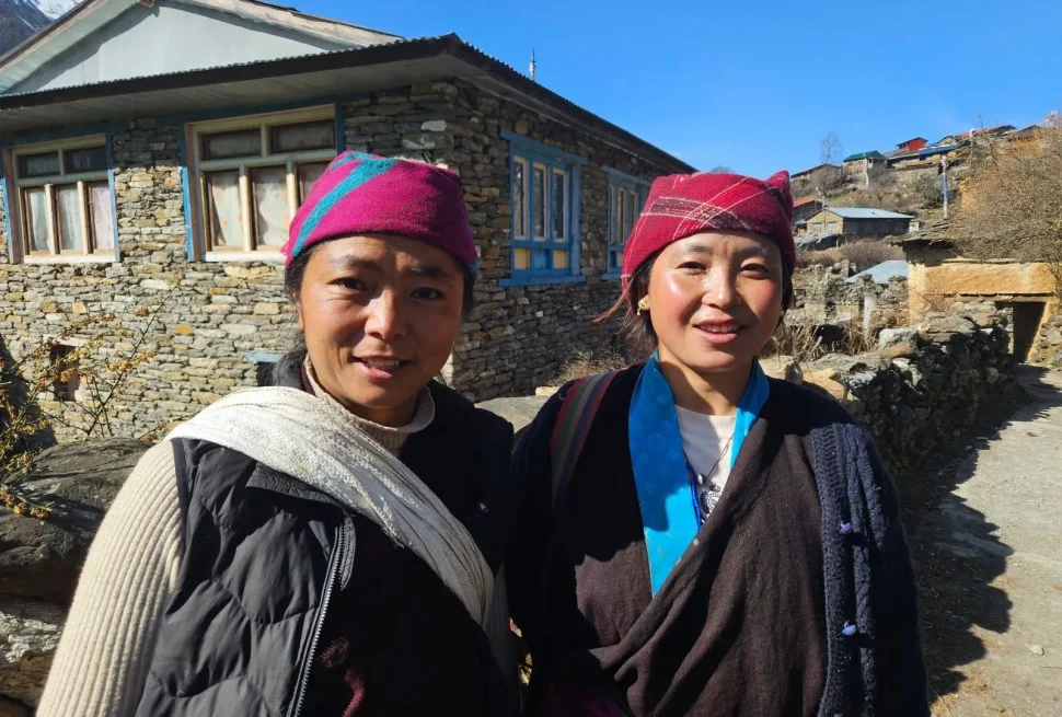
A Region of Layered Ethnic Identity
The Manaslu trekking route moves through a striking sequence of ethnic communities as elevation increases. In the lower hills around Soti Khola, Machha Khola, Jagat, and Philim, the population is predominantly Gurung, alongside Magar, Chhetri, Brahmin, Thakali, and Newar communities — many with deep historical ties to the Gorkha Kingdom and a long tradition of military service in the Gurkha regiments of the British and Indian armies.
As the trail climbs into the upper Budhi Gandaki valley — the area generally referred to as the Nubri Valley — the cultural character shifts decisively toward Tibetan Buddhist tradition. The dominant communities here, often referred to as Bhotia (or Bhutia), trace their ancestry to migrations from the Kham region of eastern Tibet, with most accounts placing this migration roughly 400–600 years ago. Villages such as Lho, Shyala, Samagaon, and Samdo are populated largely by Bhotia families who maintain a lifestyle, architecture, and religious practice closely tied to the Tibetan plateau just across the nearby border.
The Tsum Valley, a separate side valley reached via a side trail near Lokpa, is home to its own closely related but distinct community, the Tsumbas, separated from the Nubri Valley population by the Chhikur River. Because Tsum Valley remained closed to outside visitors until 2008 — decades after the main Nubri route opened — its culture, language, and religious practice are often described as even more intact and untouched than Nubri’s.
Religion: Tibetan Buddhism in Daily Life
Both the Nubri and Tsum communities practice forms of Tibetan Buddhism, predominantly aligned with the Nyingma tradition (the oldest of the four major schools of Tibetan Buddhism), often blended with older Bon shamanistic elements that predate Buddhism’s arrival in the Himalaya.
Religious life is visibly woven into the landscape itself:
- Mani walls — long stone walls carved with the Buddhist mantra Om Mani Padme Hum — line trail sections throughout the upper valleys, and trekkers are traditionally expected to pass them on the left side, in a clockwise direction, as a sign of respect.
- Chortens (stupas) mark village entrances and significant points along the trail.
- Prayer flags in the five sacred colors flutter from rooftops, bridges, and high points, believed to carry blessings and prayers into the wind.
- Monasteries (gompas) anchor village religious life — Lho’s monastery, Samagaon’s monastery, the roughly 250-year-old Pungyen Gompa, and Tsum Valley’s renowned Mu Gompa and Rachen Gompa are among the most significant on the route.
Notable Cultural and Religious Sites
| Site | Location | Significance |
|---|---|---|
| Lho Monastery | Lho village | Striking setting with close Manaslu views; active community monastery |
| Pungyen Gompa | Near Samagaon | Roughly 250 years old; reachable via a side trail |
| Mu Gompa | Upper Tsum Valley (~3,700 m) | One of the most important spiritual centers in Tsum |
| Rachen Gompa | Tsum Valley (~3,240 m) | A nunnery with deep historical roots |
| Manakamana-linked lower region | Gorkha District lowlands | Connects the trek’s start to the broader Nepali Hindu pilgrimage tradition |
Festivals
Local festivals follow the Tibetan lunar calendar and offer trekkers — if their timing aligns — a rare window into community life:
- Lhosar (Tibetan New Year) — celebrated with feasting, dancing, and family gatherings
- Dumje — an important Nubri festival celebrating the birth of Guru Rinpoche (Padmasambhava), the figure credited with bringing Tantric Buddhism to the Himalayan region
- Saka Dawa — a sacred Buddhist observance marking the Buddha’s birth, enlightenment, and death
- Dashain and Tihar — major Hindu festivals celebrated more prominently in the lower, Gurung-dominated sections of the trek, often falling within the October trekking season
A Note on Cultural Etiquette
Trekkers are encouraged to:
- Walk clockwise around mani walls, chortens, and monasteries (always pass on the left)
- Ask permission before photographing individuals, religious ceremonies, or monastery interiors
- Dress modestly, particularly when visiting monasteries
- Avoid touching the heads of monks, children, or religious statues
- Remove shoes when entering monastery prayer halls, and follow your guide’s lead on appropriate behavior
- Refrain from public displays of affection in conservative village settings
- Note that the Tsum Valley in particular is governed by a strong non-violence ethic rooted in Buddhist principle — hunting and animal slaughter are traditionally prohibited within the valley, and visitors are expected to respect this completely
16. Flora and Fauna of the Manaslu Conservation Area
A Himalayan Biodiversity Hotspot
The Manaslu Conservation Area (MCA), established in 1998 and spanning 1,663 square kilometers, is recognized as one of the significant biodiversity hotspots of the Himalaya. Its elevation range — from around 600 meters in the subtropical lowlands to over 8,000 meters at the summit of Manaslu itself — creates an unusually compressed sequence of ecological zones within a single protected area, supporting roughly 2,000 recorded plant species across eleven distinct forest types.
Vegetation by Elevation Zone
| Elevation Zone | Approx. Range | Dominant Vegetation |
|---|---|---|
| Subtropical | 600–1,400 m | Sal and castanopsis forest, ferns, orchids in humid soils |
| Lower temperate | 1,400–2,000 m | Mixed broadleaf forest, terraced agricultural land |
| Upper temperate | 2,000–3,000 m | Oak and pine forest, with rhododendron understory |
| Subalpine | 3,000–4,000 m | Birch, juniper, dwarf rhododendron, bamboo thickets (key red panda habitat) |
| Alpine | 4,000–5,000 m | Alpine meadow, hardy wildflowers, sparse grasses |
| Trans-Himalayan/nival | 5,000 m+ | Minimal vegetation; rock, scree, permanent snow and ice |
Rhododendron forests — Nepal’s national flower — put on their most vivid display in the lower-to-mid elevation sections during spring (roughly March through May), making this one of the most photographed aspects of a springtime trek.
Notable Mammal Species
| Species | Conservation Status | Notes |
|---|---|---|
| Snow leopard (Panthera uncia) | Vulnerable (IUCN) | Estimated 30–40 individuals in the broader landscape; extremely rarely sighted by trekkers |
| Red panda (Ailurus fulgens) | Endangered (IUCN) | Found in bamboo-rich temperate/subalpine forest, particularly near Namrung, Lho, and Samdo; nocturnal and rarely seen |
| Himalayan tahr (Hemitragus jemlahicus) | Near Threatened | The most commonly visible large mammal, often seen on steep slopes near Larkya La |
| Himalayan musk deer (Moschus chrysogaster) | Endangered | Historically hunted for musk gland; now protected |
| Blue sheep / bharal | Least Concern, but ecologically vital | Primary prey species for snow leopards |
| Grey wolf | Vulnerable | Present in higher, more remote sections |
| Himalayan black bear / Asian black bear | Vulnerable | Found in forested mid-elevation zones |
| Assam macaque | Near Threatened | Found in lower forested sections |
| Woolly hare, Himalayan marmot, Himalayan goral, mainland serow | Various | Smaller mammals encountered across multiple zones |
The MCA is recorded to host approximately 33 mammal species in total.
Birdlife
Over 110 bird species have been documented within the conservation area, including:
- Himalayan monal (Nepal’s national bird, known for its iridescent plumage)
- Himalayan griffon and golden eagle
- Snow partridge and Tibetan snowcock
- Chukor partridge
Other Wildlife
The area also supports three recorded reptile species and around 11 butterfly species, alongside a range of amphibians adapted to the region’s varied elevation zones.
Conservation Challenges
Despite formal protection, the MCA faces real and growing pressures:
- Climate change is shifting vegetation zones and shrinking suitable alpine habitat for cold-adapted species like the snow leopard and red panda.
- Poaching, though reduced through community-based conservation programs, remains a concern for high-value species.
- Balancing tourism growth with ecological integrity is an ongoing management challenge, particularly as trekker numbers slowly rise following the 1991 opening and subsequent infrastructure improvements.
Trekkers contribute directly to ongoing conservation work simply by paying the required MCAP permit fee, which funds patrols, community conservation education, and habitat monitoring (including camera-trap and GPS-collar research on snow leopard populations conducted with support from organizations such as the National Trust for Nature Conservation and WWF). Staying on marked trails, packing out all waste, and avoiding any disturbance to wildlife are simple but meaningful ways for trekkers to support these ongoing efforts.
17. The Tsum Valley Extension
What Makes Tsum Valley Different
Tsum Valley branches off the main Manaslu Circuit near the village of Lokpa and pushes deeper into an even more isolated side valley, separated from the main Nubri route by the Chhikur River. While Nubri opened to limited outside contact around 1950 and to formal trekking in 1991, Tsum Valley remained closed until 2008 — meaning its culture, architecture, and religious practice had close to six decades longer to remain untouched by outside influence after the rest of the region began welcoming visitors.
Highlights of the Tsum Valley Side Trip
- Mu Gompa (~3,700 m) — one of the most important monasteries in the valley and a major spiritual destination
- Rachen Gompa (~3,240 m) — a significant nunnery with deep historical roots
- Mani walls and chortens lining nearly every village approach, reflecting the valley’s status as one of Nepal’s most devoutly Buddhist communities
- The valley’s non-violent tradition — hunting and animal slaughter are prohibited under long-standing local Buddhist custom, giving the valley an unusually tranquil, undisturbed character even by Himalayan standards
Permit and Logistics
A separate Tsum Valley Permit is required in addition to the standard Manaslu permits, priced seasonally (roughly USD 30–40 for the first week, with additional daily fees beyond that). Like the main Manaslu permits, it can only be issued through a registered trekking agency, and the same mandatory guide requirement applies.
How Much Extra Time to Budget
Adding Tsum Valley to a standard Manaslu Circuit itinerary typically requires 5–7 additional days, depending on how deep into the valley you go and whether you visit both Mu Gompa and Rachen Gompa. Given the valley’s lower average elevation compared with the main circuit’s upper sections, it is also more accessible across a slightly wider range of months than the high pass itself, making it a strong option for travelers who want deep cultural immersion without pushing to extreme altitude.
18. Guides, Porters, and the Solo Trekking Rules
Why a Guide Is Legally Required
Because the Manaslu region is a government-designated Restricted Area along a sensitive section of the Tibet border, Nepali law requires every foreign trekker to be accompanied by a government-licensed guide for the entire restricted-area portion of the route. This is not a suggestion from trekking agencies — it is a legal requirement enforced at checkpoints, beginning at Jagat.
The rationale generally cited by Nepali authorities and the trekking industry rests on three pillars:
- Safety. The terrain is genuinely remote, rescue infrastructure is limited compared with Everest or Annapurna, and the risk of accidents, route-finding errors, or unmanaged altitude sickness is meaningfully higher without trained local support.
- Cultural sensitivity. Guides act as cultural interpreters in the deeply traditional Nubri and Tsum communities, helping visitors navigate religious etiquette and avoid unintentionally disrupting local life.
- National security and border management. The region’s proximity to Tibet (China) gives the Nepali government a direct security interest in monitoring foreign movement through the area.
Porters
While not legally mandatory as guides are, hiring a porter is strongly recommended given the trek’s length and the strenuous nature of the Larkya La crossing. Porters typically carry up to 20–25 kg of a trekker’s gear, often split between two trekkers per porter, dramatically reducing fatigue and lowering the physical strain that contributes to altitude-related problems.
The Evolving Solo Trekking Rules
For most of the post-1991 history of this trek, the Restricted Area Permit could only be issued to groups of two or more foreign trekkers — a rule that effectively forced solo travelers to either join an existing group tour or be administratively “paired” with another solo trekker by their agency purely to satisfy the permit requirement (even if the two trekkers never walked together).
Multiple 2026 industry sources indicate that Nepal’s Department of Immigration has relaxed this minimum-group-size rule, now allowing individual foreign trekkers to obtain the Restricted Area Permit without needing a second person attached to the same paperwork. This is a meaningful change for independent-minded travelers.
However, this does not mean unguided solo trekking has become legal. The licensed-guide requirement remains firmly in place, and the region remains a Restricted Area requiring agency-processed permits regardless of group size. Always confirm the latest rule directly with a TAAN-registered trekking agency or Nepal’s Department of Immigration before booking, since the restricted-area policy in Nepal can change between seasons.
Choosing a Trekking Agency
When selecting an agency for the Manaslu Circuit, look for:
- Formal registration with the Trekking Agencies’ Association of Nepal (TAAN)
- Guides holding valid licenses issued by the Nepal Tourism Board
- A transparent, itemized cost breakdown (permits, guide, porter, food, lodging, transport listed separately rather than bundled into a vague total)
- Demonstrated experience specifically on the Manaslu Circuit and Larkya La Pass, not just general Nepal trekking experience
- Clear policies on insurance, emergency evacuation procedures, and itinerary flexibility for weather delays
- Manaslu Treks and Expedition is the best Manaslu Circuit Trek Company with years of experience
19. Manaslu vs. Annapurna vs. Everest Base Camp
A common planning question for trekkers choosing between Nepal’s major trekking regions. Here’s an evenhanded side-by-side comparison.
| Factor | Manaslu Circuit | Annapurna Circuit | Everest Base Camp |
|---|---|---|---|
| Typical Duration | 12–18 days | 12–21 days (shorter with road shortcuts) | 12–14 days |
| Highest Point | Larkya La Pass (~5,106–5,160 m) | Thorong La Pass (~5,416 m) | Kala Patthar (~5,545 m) |
| Permit Type | Restricted Area Permit (mandatory guide, agency-only) | Open trekking area (ACAP permit only, independent trekking allowed) | Open trekking area (Sagarmatha National Park permit, independent trekking allowed) |
| Crowd Levels | Low | Moderate to high (busy in peak season) | Very high (busiest trek in Nepal) |
| Infrastructure | Basic; fewer teahouses, fewer amenities | Well-developed; bakeries, Wi-Fi, varied menus common | Highly developed; flights, helicopter options, luxury lodges available |
| Cultural Character | Strong, well-preserved Tibetan Buddhist culture (Nubri/Tsum) | Mixed Hindu/Buddhist, increasingly modernized in places | Sherpa Buddhist culture, somewhat commercialized near EBC |
| Road Encroachment | Limited but growing on lower sections | Significant; roads now reach much of the original trekking trail | Minimal; flight to Lukla largely bypasses road issues |
| Cost (typical package) | USD 1,100–2,800 | USD 900–2,000 | USD 1,200–2,500 (excluding flights) |
| Overall Difficulty | Moderate to strenuous | Moderate to strenuous | Moderate to strenuous |
| Best For | Trekkers wanting remoteness, culture, and fewer crowds | Trekkers wanting variety, good infrastructure, and flexibility | Trekkers wanting the iconic Everest views and bucket-list status |
The Short Version
If your priority is solitude, cultural depth, and a genuine sense of wilderness, Manaslu is very likely the strongest choice among the three. If you want maximum trail comfort, flexibility, and the ability to trek independently without a mandatory guide, the Annapurna Circuit remains highly attractive despite increasing road development. If your goal is standing at the foot of the world’s highest mountain and you’re comfortable with significant crowds and a higher overall cost, Everest Base Camp remains the iconic choice.
Many experienced trekkers ultimately complete all three over multiple trips — and a fair number specifically describe Manaslu as the trek that most closely recreates the feeling Annapurna had before its trails were paved and connected by road.
20. Responsible and Sustainable Trekking
Why It Matters More Here
The Manaslu region’s relative lack of large-scale tourism infrastructure is precisely what makes it special — and precisely what makes it more fragile than heavily developed routes. Every trekker passing through has an outsized opportunity (and responsibility) to help keep it that way.
Practical Steps Trekkers Can Take
- Pack out what you pack in. Carry a small trash bag and take all non-biodegradable waste (wrappers, batteries, plastic) back out with you rather than relying on limited village waste systems.
- Use water purification instead of buying bottled water. Plastic bottle waste is a growing problem on Himalayan trails with no formal recycling infrastructure; a filter or purification tablets eliminate this entirely.
- Choose local, family-run teahouses rather than any larger camping-style operations where available, since lodging spending flows more directly into village livelihoods this way.
- Hire local guides and porters through registered agencies, and pay fair wages and customary tips — tourism income is a primary livelihood source for many Nubri and Tsum families.
- Respect wildlife viewing distances and never attempt to approach or feed animals, including the more commonly seen Himalayan tahr.
- Limit firewood-dependent showers and heating where possible, since deforestation pressure from cooking and heating fuel remains a genuine concern in parts of the conservation area.
- Follow cultural etiquette closely (see Section 15) to minimize disruption to deeply traditional communities still adjusting to growing tourism.
- Support conservation directly by ensuring permit fees are paid properly through your registered agency rather than seeking under-the-table shortcuts — these fees are a primary funding source for the Manaslu Conservation Area’s ongoing work.
The Bigger Picture
Tourism revenue, when properly channeled, has become one of the most effective levers for both conservation funding and rural community development in the Manaslu region since the 1991 opening. Responsible trekkers are not simply minimizing harm — they are actively participating in a model that has, by most accounts, kept this corner of the Himalaya markedly more intact than many of its more famous neighbors.
21. Frequently Asked Questions
1. How long is the Manaslu Circuit Trek? Most itineraries run 12–18 days including travel days to and from Kathmandu, covering a total trekking distance of roughly 150–180 km depending on the exact starting point and any side trips taken.
2. What is the highest point of the Manaslu Circuit Trek? Larkya La Pass, recorded at approximately 5,106–5,160 meters depending on the source and exact measurement point, is the trek’s highest elevation.
3. Do I need a guide for the Manaslu Circuit Trek? Yes. A licensed guide is legally mandatory because the region is classified as a Restricted Area. This requirement applies regardless of recent changes to the minimum-group-size rule for permits.
4. Can I trek the Manaslu Circuit solo? As of 2026, reports indicate Nepal’s Department of Immigration has removed the previous two-person minimum for the Restricted Area Permit, making it easier for individual travelers to obtain permits. However, you still cannot trek without a licensed guide and registered agency support — fully independent, unguided trekking remains prohibited in this region. Always verify current rules with an agency before booking.
5. How much does the Manaslu Circuit Trek cost? Total costs typically range from USD 1,100 to 2,800 per person for a standard 12–18 day trek, depending on group size, season, and service level, with luxury/fully private options running higher.
6. What permits do I need? The Manaslu Restricted Area Permit (RAP), Manaslu Conservation Area Permit (MCAP), Annapurna Conservation Area Permit (ACAP), and a Chumnubri Rural Municipality Permit (CRMP) are required. A separate Tsum Valley Permit is needed only if you extend into that side valley. A TIMS card is not required for this specific trek.
7. When is the best time to trek the Manaslu Circuit? Spring (March–May) and autumn (September–November) are the recommended seasons, offering the most stable weather and clearest mountain views. October is frequently cited as the single most reliable month.
8. Is the Manaslu Circuit Trek difficult? It is generally rated moderate to strenuous — comparable to, or slightly more demanding than, the Annapurna Circuit — with notably high and sustained passes and more limited rescue infrastructure than on busier routes.
9. Is previous trekking experience required? It’s not strictly required, but prior multi-day hiking experience and reasonable cardiovascular fitness are strongly recommended. First-time high-altitude trekkers should choose a longer itinerary with full acclimatization days.
10. What is the risk of altitude sickness? Real and meaningful, given multiple nights spent above 3,500 m and a pass crossing above 5,100 m. Gradual ascent, proper acclimatization days, hydration, and honest communication with your guide significantly reduce this risk.
11. What kind of accommodation should I expect? Basic teahouse lodging throughout, with simple twin-sharing rooms, mostly shared bathroom facilities, and increasingly limited amenities (hot showers, Wi-Fi, charging) the higher you climb.
12. Will I have phone or internet access? Coverage exists in parts of the lower and middle route but becomes intermittent and unreliable in the upper villages (Samdo, Dharamsala). Don’t plan around consistent connectivity.
13. Do I need travel insurance? Yes — comprehensive travel insurance covering high-altitude trekking and helicopter evacuation (often specifically required up to 6,000 m) is considered essential, both for safety and because agencies typically request proof of it during permit processing.
14. Can children or older trekkers do this trek? There’s no official age restriction, and fit trekkers across a wide age range complete it each season, but anyone with health concerns, very young children, or limited experience reading their own altitude tolerance should plan extra conservatively and consult a doctor beforehand.
15. What is the food like on the trek? Primarily dal bhat (lentils, rice, vegetable curry), noodle dishes, momos, basic egg dishes, and a range of teas — fairly simple but generally nourishing, with prices and freshness both declining somewhat the higher you go.
16. Should I hire a porter? It’s not legally required but is widely recommended given the trek’s length and the demanding Larkya La crossing — porters meaningfully reduce physical strain, which in turn helps reduce altitude-sickness risk.
17. Can I combine the Manaslu Circuit with other treks? Yes. Because the trail ends near Dharapani, it connects directly into the Annapurna Circuit trail, and many trekkers with extra time continue on toward Manang, Tilicho Lake, or over Thorong La Pass. The Tsum Valley side trip is also commonly added at the start of the trek.
18. Is the Manaslu Circuit Trek safe? With a licensed guide, proper acclimatization, appropriate gear, and comprehensive insurance, the trek has a strong safety record. The main risks — altitude sickness and weather-related pass closures — are well understood and manageable with sensible planning.
19. What’s the biggest mistake first-time Manaslu trekkers make? Compressing the itinerary too aggressively to save time or money, which removes the acclimatization buffer that makes the Larkya La crossing genuinely safe rather than genuinely risky.
20. How does Manaslu compare to the Annapurna Circuit? Manaslu offers a notably quieter, more culturally intact, and more remote experience, at the cost of more basic infrastructure and the legal requirement of a guide. Annapurna offers more developed amenities, a comparable pass altitude, and the option of fully independent trekking, but has seen significant road encroachment in recent years.
Final Thoughts
The Manaslu Circuit Trek occupies a particular and increasingly rare position in Himalayan trekking: remote enough to feel like genuine exploration, culturally rich enough to leave a lasting impression well beyond the mountain views themselves, and just regulated enough — through its Restricted Area status — to have largely escaped the rapid commercialization that has reshaped Nepal’s most famous routes.
A successful trip here is less about raw fitness and more about respect for the process: building in enough time for proper acclimatization, choosing a registered agency with real Manaslu-specific experience, packing thoughtfully for a route with few backup options, and approaching the deeply traditional Nubri and Tsum communities with genuine cultural curiosity rather than as a backdrop for photographs.
For trekkers who have already experienced the Everest or Annapurna regions and are searching for something that recaptures the sense of discovery those trails once offered, or for first-time Himalayan trekkers willing to invest a little extra planning for a meaningfully different kind of adventure, the Manaslu Circuit — and the dramatic crossing of Larkya La Pass at its heart — remains one of the most rewarding multi-day treks anywhere in the world.
This guide was compiled from extensive research across current trekking-industry sources, permit regulations, and seasonal weather data as of mid-2026. Permit prices, regulations (particularly around solo trekking rules), and trail infrastructure can change; always confirm current details with a registered Nepali trekking agency before booking your trip.
Appendix A: Visa, Flights, and Getting to Nepal
Visa on Arrival
Most nationalities can obtain a Nepal tourist visa on arrival at Tribhuvan International Airport (Kathmandu) or at major land border crossings, by paying a fee in cash (USD or major foreign currency) or via the airport’s electronic payment kiosks. Standard tourist visa options typically include 15-day, 30-day, and 90-day multiple-entry visas. Given that a Manaslu Circuit trip — including pre-trek prep days, the trek itself, and a buffer day or two for weather — often runs close to three weeks, most trekkers choose the 30-day visa option to leave a comfortable margin. A passport valid for at least six months beyond your travel dates, plus one or two passport-sized photos, makes the arrival process smoother (though photos can often be taken digitally at the kiosk if you forget physical copies).
Flights into Kathmandu
Tribhuvan International Airport (KTM) is Nepal’s main international gateway, served by direct and connecting flights from major hubs across South Asia, the Middle East, and parts of East Asia, with onward connections from Europe and North America typically routing through cities like Delhi, Doha, Dubai, Bangkok, Singapore, or Istanbul. Booking flights with some flexibility around your departure date is wise, since high-altitude trek itineraries can occasionally shift by a day due to weather, particularly around the Larkya La crossing.
Getting From Kathmandu to the Trailhead
Trekkers reach the start of the Manaslu Circuit (Soti Khola or Machha Khola) via a long road journey of roughly 7–9 hours, typically following the Prithvi Highway west toward Dhading and then turning north through Arughat. Two main options exist:
| Transport Option | Approx. Cost | Approx. Duration | Notes |
|---|---|---|---|
| Local/shared bus | USD 10–20 | 8–10+ hours | Cheapest option; can be crowded and slower, especially on rough sections beyond Arughat |
| Private jeep | USD 150–250 (one-way, shared among group) | 6–8 hours | More comfortable, flexible departure time, recommended for groups or those short on time |
Road conditions beyond Arughat Bazaar can be rough, occasionally requiring sturdy 4WD vehicles, particularly during or shortly after the monsoon when landslide damage may not yet be repaired.
Getting Back From the Trek’s End Point
The return journey from Dharapani or Besisahar back to Kathmandu mirrors the outbound trip in reverse, typically taking 8–9+ hours by road, sometimes broken into two legs via Besisahar and Pokhara connections for trekkers wanting to add a stop in Pokhara before returning to the capital.
Currency and Connectivity
Nepal’s currency is the Nepali Rupee (NPR). Currency exchange and ATMs are widely available in Kathmandu but become sparse quickly once you leave the city — plan to withdraw or exchange sufficient cash before departing for the trailhead, since there are effectively no reliable ATMs once you’re north of the lower trailhead villages. Nepali SIM cards (Ncell and Nepal Telecom/NTC being the two major providers) can be purchased in Kathmandu with your passport and a photo, and NTC in particular tends to have somewhat better coverage in remote mountain districts, though service in the upper Manaslu villages remains patchy regardless of provider.
Appendix B: Sample Budget Calculator
The table below illustrates how a complete Manaslu Circuit Trek budget might break down across three different service tiers for a 14-day standard itinerary (excluding international flights to/from Nepal).
| Expense Category | Budget Tier (Group) | Standard Tier (Small Group) | Comfort Tier (Private) |
|---|---|---|---|
| Permits (RAP+MCAP+ACAP+CRMP) | $190 (spring) / $250 (autumn) | $190 / $250 | $190 / $250 |
| Guide (14 days, shared/private) | $350 (shared across group) | $420 | $500 (dedicated) |
| Porter (14 days) | $200 (shared, 1 per 2 trekkers) | $280 | $350 (dedicated) |
| Accommodation (14 nights, teahouse) | $40–60 total | $70–100 total | $120–180 total |
| Meals (14 days, 3 meals/day) | $280–350 | $350–420 | $420–500 |
| Kathmandu–Soti Khola transport (round trip) | $30–40 (local bus) | $80–120 (shared jeep) | $250–400 (private jeep) |
| Kathmandu hotel (3 nights, pre/post trek) | $45–90 | $90–150 | $150–300 |
| Travel insurance | $80–120 | $100–150 | $100–200 |
| Tips for guide/porter | $100–150 | $150–200 | $200–250 |
| Miscellaneous (snacks, charging, Wi-Fi, hot showers, souvenirs) | $80–120 | $100–150 | $150–250 |
| Approximate Total (per person) | $1,400–1,700 | $1,850–2,250 | $2,400–3,300 |
These figures are illustrative estimates meant to help with planning, not a quote — always request a fully itemized quote from a TAAN-registered agency for your specific dates, group size, and season, since permit fees, fuel surcharges, and lodging prices can shift from year to year.
Appendix C: Common Mistakes First-Time Manaslu Trekkers Make
1. Booking a too-short an itinerary to save money. Shaving two or three days off a standard itinerary might save a few hundred dollars in permits, food, and staff costs — but it usually does so by cutting the very acclimatization days that make the Larkya La crossing safe. This is, by a wide margin, the most consequential mistake trekkers make when planning this trip.
2. Underestimating the cold at Dharamsala and Larkya La. Trekkers coming from the relatively mild lower valleys sometimes assume a “spring” or “autumn” trek means moderate temperatures throughout. Pre-dawn starts at Dharamsala, ahead of the pass crossing, regularly involve temperatures well below freezing, even in the warmer trekking seasons.
3. Choosing an agency based on price alone. The cheapest quoted price sometimes reflects unlicensed or inexperienced guides, under-resourced emergency planning, or hidden costs that appear later (porter fees, “optional” permit processing charges, etc.). Verifying TAAN registration and guide licensing is worth the extra diligence.
4. Skipping travel insurance, or buying insurance that doesn’t cover high-altitude evacuation. Standard travel insurance policies frequently exclude trekking above a certain altitude (often 3,000–4,000 m) unless a specific high-altitude or adventure-sports rider is added. Always confirm the policy explicitly covers your planned maximum altitude and helicopter evacuation.
5. Ignoring early AMS symptoms because “everyone feels a bit off at altitude.” Mild headaches and fatigue are common at altitude, but the habit of pushing through worsening symptoms rather than reporting them to your guide is one of the most preventable causes of serious altitude illness on this route.
6. Overpacking — or underpacking for cold. Because gear cannot easily be purchased once you leave Kathmandu, some trekkers either bring far too much (adding unnecessary weight and fatigue) or fail to bring adequate cold-weather layers for the pass, having underestimated how dramatically temperatures drop above 4,000 meters.
7. Not breaking in trekking boots before departure. New, unbroken boots on a multi-day trek is one of the most reliable ways to develop trail-ending blisters within the first two or three days.
8. Drinking untreated water. Even crystal-clear mountain streams can carry bacteria or parasites; always purify water via filtration, tablets, or boiling, regardless of how “clean” the source looks.
9. Underestimating the value of a porter. Some trekkers, aiming to “prove” their fitness, decline a porter and end up carrying a heavy pack through the most demanding days of the trek, increasing fatigue and altitude-sickness risk in the process — without any real safety or experiential benefit to compensate.
10. Assuming mobile coverage will be reliable for navigation or communication. Trekkers who rely entirely on phone-based mapping or assume they can easily call for help at any point on the trail are setting themselves up for a difficult surprise in the upper villages, where coverage is inconsistent at best.
Appendix D: Glossary of Trekking and Cultural Terms
| Term | Meaning |
|---|---|
| Teahouse | A small, family-run lodge offering basic rooms and meals along the trekking route |
| Gompa | A Tibetan Buddhist monastery |
| Chorten | A Buddhist stupa or shrine, often marking village entrances or trail junctions |
| Mani wall | A long stone wall carved with Buddhist mantras, traditionally passed on the left |
| Bhotia / Bhutia | A term referring to communities of Tibetan ethnic origin living in Nepal’s high Himalayan valleys |
| Nubri | The upper Budhi Gandaki valley region and its Tibetan-descended community, the cultural heart of the main Manaslu Circuit |
| Tsumba | The people of Tsum Valley, a closely related but distinct community to Nubri |
| RAP | Restricted Area Permit — the main permit required for the Manaslu Circuit’s restricted zone |
| MCAP | Manaslu Conservation Area Permit |
| ACAP | Annapurna Conservation Area Permit |
| AMS | Acute Mountain Sickness — the mild-to-moderate form of altitude illness |
| HAPE | High Altitude Pulmonary Edema — a severe, potentially fatal lung-related altitude illness |
| HACE | High Altitude Cerebral Edema — a severe, potentially fatal brain-related altitude illness |
| Dal bhat | The Nepali staple meal of lentil soup, rice, and vegetable curry, a trekking-route mainstay |
| Larkya La / Larke La | The Manaslu Circuit’s highest mountain pass, connecting the Manaslu and Annapurna regions |
| Lhosar | Tibetan New Year, a major festival celebrated in Buddhist Himalayan communities |
| Phedi | A Nepali term meaning “base” or “foot of,” as in Larkya Phedi (base of the Larkya pass) |
| TAAN | Trekking Agencies’ Association of Nepal — the regulatory body for registered trekking agencies |
Appendix E: Photography Tips for the Manaslu Circuit
The Manaslu Circuit offers an unusually wide range of photographic subject matter within a single trek — dramatic river gorges, close-up mountain faces, traditional Tibetan-style architecture, and one of the most visually rewarding high-pass crossings in Nepal. A few practical tips can help trekkers make the most of it.
Golden hour at Lho and Shyala. The first close, unobstructed views of Mount Manaslu typically appear around Lho village, and the early morning and late afternoon light here is consistently described by photographers as some of the best on the entire route — soft, warm light raking across the mountain face with minimal haze, particularly in autumn.
Protect your gear from cold and condensation. Camera batteries drain faster in cold temperatures, especially above 3,500 meters. Keep spares in an inner jacket pocket close to your body, and allow equipment to acclimatize gradually as you move between cold outdoor air and a warmer teahouse interior to avoid condensation damage to lenses and sensors.
The pass crossing is worth the extra weight. Many trekkers are tempted to leave heavier camera gear behind on the Larkya La crossing day given how demanding it is — but the panoramic view from the summit (when weather cooperates) is widely considered one of the single best vistas on the trek, and a lightweight zoom or wide-angle lens can be well worth the marginal extra weight for that one day.
Respect photography etiquette in religious and community settings. Always ask permission before photographing individuals, monastery interiors, or active religious ceremonies — this is both a matter of basic respect and, in some monasteries, an explicit local rule. Many monks and villagers are happy to be photographed when asked directly, especially if you take a moment to show genuine interest in what they’re doing rather than treating it purely as a photo opportunity.
Pack a polarizing filter if you shoot with a dedicated camera. The combination of high-altitude UV intensity, snow glare near the pass, and deep blue skies in clear autumn conditions makes a polarizing filter genuinely useful for cutting haze and improving contrast in mountain shots.
Don’t forget the smaller details. While the temptation is to chase wide mountain panoramas, some of the most memorable images from this trek come from smaller details — prayer flags against a clear sky, the texture of a centuries-old mani wall, steam rising from a morning dal bhat in a frost-covered teahouse window, or the quiet concentration on a monk’s face during a monastery ritual.
Appendix F: Pre-Departure Checklist
A condensed, practical checklist to run through in the weeks before departure:
- [ ] Booked a TAAN-registered trekking agency with verified Manaslu-specific experience
- [ ] Confirmed your itinerary includes at least one full acclimatization day (ideally at Samagaon)
- [ ] Purchased travel insurance explicitly covering high-altitude trekking and helicopter evacuation up to at least 6,000 m
- [ ] Applied for or confirmed your Nepal tourist visa (30-day option recommended)
- [ ] Submitted passport scan, visa copy, photos, and insurance details to your agency for permit processing (RAP, MCAP, ACAP, CRMP, plus Tsum Valley permit if applicable)
- [ ] Started a structured 8–12 week physical training plan
- [ ] Broken in trekking boots with multiple practice hikes
- [ ] Packed and tested all layering pieces, sleeping bag, and trekking poles
- [ ] Arranged sufficient Nepali Rupees in cash for the full trek duration (no reliable ATMs beyond the lower trailhead villages)
- [ ] Discussed any altitude-related medication options with your doctor
- [ ] Backed up trail maps/offline navigation in case of unreliable mobile coverage
- [ ] Set aside at least one buffer day in your overall trip schedule in case of weather delays at the pass
- [ ] Researched basic cultural etiquette for Nubri and Tsum Valley communities
- [ ] Shared your itinerary and emergency contacts with someone at home
With permits sorted, gear packed, and a sensibly paced itinerary in hand, the only thing left is the walk itself — and few walks in the world reward the planning quite like the road around Mount Manaslu.