Written by Kiran Basnet, Senior Trekking Expert at Manaslu Treks and Expedition. Nearly every client who books the Manaslu Circuit Trek asks some version of the same two questions eventually, usually somewhere between confirming their itinerary and finalizing their packing list. What should I actually bring to take genuinely good photos, and can I fly my drone here. Both questions deserve a proper answer rather than a quick line in a packing list, because the Manaslu region is a restricted, protected conservation area, and the rules around drones in particular are more involved, more layered across several government offices, and more easily gotten wrong, than most trekkers expect. This guide covers both topics together in full, since they genuinely overlap on this specific trek, and since the people who ask about one almost always end up asking about the other within the same conversation anyway.
One honest note before we begin. Nepal’s drone regulations involve several government bodies, are not always described identically across different sources, and appear to have been updated at various points in recent years. We have done our best to give you an accurate, current picture here, but given how much is genuinely at stake, meaning potential confiscation of expensive equipment, we strongly encourage you to confirm the current process directly with Nepal’s Civil Aviation Authority and with our office before you pack a drone for this specific trip rather than relying on any single blog post, including ours, as a final authority. Treat the numbers and steps below as a serious, well researched starting point for that conversation, not as the final word. We would rather tell you plainly where our research found conflicting figures than present a tidy but potentially inaccurate rulebook, since getting this wrong carries real consequences for your equipment and your trip.
Photography First, the Easier Half of This Guide
Let us start with the straightforward part. Handheld photography, whether with a phone, a compact camera, or a full mirrorless or DSLR setup, faces no special legal restriction on this trek beyond ordinary courtesy and respect at religious sites, which we cover further below. What actually determines whether you come home with photos you love is less about gear and more about understanding the light, the route, and a handful of specific viewpoints that experienced guides know well.
Gear Worth Bringing
- A camera you are genuinely comfortable operating with gloves on, since the best light at altitude often appears early morning or at dusk when temperatures are at their coldest
- At least one versatile zoom lens if you shoot with an interchangeable lens camera, since carrying multiple lenses up to the pass adds real weight for marginal benefit on a trek this demanding
- A polarizing filter, which meaningfully improves sky contrast and cuts glare off snow and ice, especially useful near the Larke La Pass
- Spare batteries, since cold temperatures drain batteries far faster than normal and charging access is limited above the lower villages, a topic we cover fully in our phone and camera battery guide
- A sturdy phone case and a simple lens cloth, since dust on the lower trail sections and condensation when moving between temperature extremes are both constant minor annoyances
The Light, and Why Timing Matters More Than Equipment
At altitude, the quality of light changes faster and more dramatically through the day than most photographers are used to at home. The hour after sunrise and the hour before sunset consistently produce the most striking images on this trek, with warm, low angled light raking across peaks like Manaslu itself and Himlung Himal, while the middle of the day tends toward flat, harsh light that washes out the kind of texture and depth that makes mountain photography compelling. If you only prioritize one habit from this entire section, make it this one. Be awake, dressed, and outside with your camera ready in the fifteen minutes around sunrise at Samagaon or Samdo, even when every part of you wants to stay in a warm sleeping bag a little longer.
Viewpoints Worth Planning Around
- Samagaon, with clear views toward Manaslu itself on a clear morning, and a good base for a side excursion toward Manaslu Base Camp or the Pungyen Monastery viewpoint if your itinerary includes an extra acclimatization day here
- Samdo, offering wide, open views back down the valley and toward the peaks lining the Tibetan border
- The approach to Dharmasala, where the landscape turns stark and dramatic as vegetation disappears and the trail enters true high alpine terrain
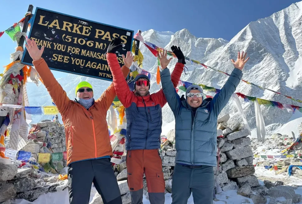
- The Larke La Pass itself at sunrise, widely considered the single best photography moment of the entire trek, with prayer flags in the foreground and a genuinely vast Himalayan panorama behind them
- Bimthang, on the descent side of the pass, offering a different and often less photographed angle on the same range of peaks
Our Larke Pass guide and our Dharmasala guide both go into more detail on timing this stretch of the route well, which matters as much for photography as it does for safety and acclimatization, since the two concerns genuinely line up more often than not on this particular section of trail.
Photographing People and Religious Sites Respectfully
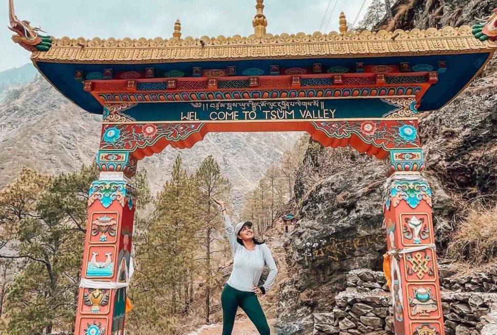
Some of the most memorable images from this trek are not landscapes at all, but portraits of village life, monasteries, and the Tibetan Buddhist culture that defines much of the Manaslu and Tsum Valley region, covered in depth in our History and Culture of Manaslu Tsum Valley guide. Always ask before photographing someone directly, and accept a no gracefully rather than pushing the point. Inside monasteries and gompas, photography is sometimes restricted entirely, particularly around certain shrines or during active prayer, and a quick question to your guide before raising your camera will tell you whether it is welcome in that specific space. Many monks and local residents are genuinely happy to be photographed once asked properly, and the resulting portraits are often more meaningful than any landscape shot, precisely because they came from a real, respectful interaction rather than a candid grab taken without anyone’s knowledge or consent.
Camera Settings for Snow, Glare, and High Contrast
Snow and ice reflect enormous amounts of light, which tricks most camera light meters into underexposing a scene, producing images where the snow looks dull gray instead of bright white. If your camera allows manual exposure control, deliberately overexposing by around one to one and a half stops compared with what the meter suggests usually produces a far more accurate, pleasing result in bright snow conditions. If you shoot on an automatic phone or compact camera without this control, look for an exposure compensation slider, which most modern phone camera apps include, and nudge it upward in bright snow scenes.
High contrast scenes, such as a dark foreground ridge against a bright snow covered peak, are common on this route and genuinely challenging for any camera’s dynamic range. Many phones now handle this reasonably well automatically through computational photography features, but if you shoot in a RAW or manual format, consider bracketing a few exposures of your favorite compositions, meaning one normal, one brighter, and one darker shot of the same scene, so you have options to work with later rather than a single exposure that might not capture the full range of light and shadow.
A Guide’s Perspective on What Actually Makes a Good Trek Photo
After walking this route more times than we can easily count, the photos that tend to mean the most to our clients afterward are rarely the technically perfect landscape shots, though those matter too. They are usually the ones that capture a specific, honest moment, a porter laughing over tea in Namrung, the particular look of relief and pride on someone’s face cresting the Larke La Pass after a hard climb, the texture of prayer flags against a storm building behind them, or the quiet, unplanned portrait of a local resident who agreed to be photographed after a genuine conversation. Equipment helps, but presence and attention to the actual moment in front of you matters more, and it is the one piece of photography advice that costs nothing and weighs nothing in your pack.
What the Weather Does to Your Photography Month by Month
Spring, roughly March through May, tends to bring warmer temperatures at lower elevation, blooming rhododendron forests on the lower trail sections, and generally clear mornings with a chance of afternoon haze or cloud building up gradually as the day warms and air currents shift across the valley. Autumn, roughly September through November, is widely regarded as offering the clearest, most consistently stable mountain visibility of the entire year, making it a strong choice specifically for photography focused trips, alongside being the busiest season on the trail overall. Winter months bring the harshest cold and the quietest, most peaceful trail, with crisp, clear air that can produce exceptionally sharp distant mountain views on a good day, balanced against genuinely difficult cold for both trekkers and camera batteries alike. The monsoon months bring the least reliable photography conditions of the year, with cloud, rain, and limited long distance visibility being the norm rather than the exception, though the lower valley greenery during this period has its own distinct, less commonly photographed appeal worth considering. Our Best Time to Trek the Manaslu Circuit guide covers this in far more detail across the full year.
Drones, Where This Gets Genuinely Complicated
Now to the harder topic. A growing number of trekkers want to bring a drone for the kind of sweeping aerial footage that has become common on social media, and we understand the appeal completely. But Nepal regulates drone use seriously, and the Manaslu region adds an extra layer of restriction on top of the national rules because it is a protected conservation area under restricted access. Flying a drone here without going through the proper process is not a minor technicality. It can result in confiscation of your equipment, fines, and in serious cases, further legal consequences that follow you well beyond the end of your trip.
How Nepal Classifies Drones
Nepal’s civil aviation regulations sort drones into weight based categories, generally described as under 250 grams, 250 grams up to 2 kilograms, 2 kilograms up to 25 kilograms, and above 25 kilograms, with heavier categories facing stricter requirements. Based on current guidance, registration with Nepal’s Civil Aviation Authority appears to apply broadly across these categories, including lighter consumer drones, rather than exempting small drones entirely the way some other countries do. Do not assume your drone is too small or too light to need registration. Confirm this specifically before you travel.
The Agencies Involved
Several different government bodies are involved in approving drone use in a conservation area like Manaslu, which is a major reason this process takes real advance planning rather than something arranged on arrival. Based on current published guidance, the chain of approval generally runs through the Civil Aviation Authority of Nepal for registration and a Unique Identification Number, the National Trust for Nature Conservation for an initial conservation related approval, a Chief District Officer or local administrative office for security clearance, the Department of National Parks and Wildlife Conservation since Manaslu falls under its jurisdiction, and finally the Manaslu Conservation Area Project office itself for the area specific permit. Foreign nationals additionally go through a security clearance step with the Ministry of Home Affairs.
Several published sources also mention that once a conservation area drone permit is granted, the operator may be required to use a designated local escort for the flight, paid for by the drone operator, similar in spirit to the guide and liaison requirements that already apply to trekking in this restricted region.
Fees, Approximate and Worth Confirming Directly
Published figures for this process include a Civil Aviation Authority registration fee in the range of 50 US dollars plus applicable tax, and a conservation related payment reported at around 12,500 Nepali rupees paid in cash at the relevant stage of approval. Beyond these two figures, other steps in the chain do not appear to have a single, clearly published fee, and the escort’s costs, covering wages, food, and accommodation during the permitted flight period, are paid separately by the operator. Treat all of these numbers as a planning estimate rather than a guaranteed final cost, and confirm current figures directly with the Civil Aviation Authority and our office well before your trip, since fees for processes like this tend to be adjusted periodically.
What Happens If You Fly Without Permission
Operating a drone without the required permits is treated as a genuine legal violation in Nepal, not a minor infraction. Published guidance describes fines, though reported figures for the fine amount vary by source and we were not able to confirm one single authoritative number, confiscation of the drone on the spot regardless of how minor the violation seems to the operator, and in more serious cases, particularly anything touching on privacy, security sensitive areas, or repeated violations, further legal action including the possibility of arrest. Nepal Police and the Civil Aviation Authority are both empowered to enforce this, and conservation area staff in a region like Manaslu are generally attentive to visitors carrying obvious camera drones, so this is not a rule that tends to go unnoticed in practice.
Given the genuine ambiguity in some of the published fine amounts, our strong practical advice is simple. Assume the consequence of flying without permission is significant, not minor, and plan accordingly rather than gambling valuable equipment on the hope that nobody notices.
General Flight Restrictions, Even With a Permit
Even once properly permitted, Nepal’s general aviation rules for drones include restrictions worth knowing. Published figures describe an altitude limit somewhere around 100 to 120 meters above ground level, a horizontal distance limit from the operator somewhere around 300 to 500 meters depending on the source, a requirement to maintain visual line of sight with the drone at all times, daylight only operation, and a substantial exclusion zone, commonly cited around 5 kilometers, from any airport or international border. Because published sources genuinely differ on the exact altitude and distance figures, treat the more conservative numbers as your working assumption and confirm the precise current limits with the Civil Aviation Authority directly.
Bringing a Drone Through Customs
Separate from conservation area and flight permission, simply bringing a drone into Nepal through airport customs involves its own declaration step. Published guidance describes travelers needing to declare imported drone equipment at Tribhuvan International Airport, and in some cases a customs clearance certificate is referenced as part of the paperwork trail connected to drone ownership in Nepal. We recommend declaring your equipment honestly at customs on arrival rather than attempting to bring it in quietly, since an undeclared drone discovered later in your trip, whether at a conservation area checkpoint or anywhere else, creates a far more complicated problem than a straightforward declaration would have.
If you are only passing through Nepal with a drone intended for use somewhere else entirely, such as a different country on a wider trip, mention this clearly at customs as well, since the honest, transparent approach is consistently the one that avoids complications, both on the way in and on the way back out when you leave with the same equipment.
Insuring Expensive Camera and Drone Equipment
If you are traveling with camera equipment worth a significant amount of money, check whether your travel insurance policy includes any coverage for personal belongings, and if so, what the per item limit is, since many standard policies cap individual item coverage at an amount well below the value of a serious camera body and lens combination. Some photographers carry a separate specialist policy for their equipment specifically, distinct from their trekking and medical travel insurance entirely. This is a financial decision rather than a safety one, but it is worth making deliberately rather than assuming your travel policy covers a dropped lens or a stolen camera bag at the same level it covers your medical and evacuation needs.
Beyond insurance, simple physical precautions matter just as much. Never leave a camera bag unattended in a teahouse dining room, keep equipment in your daypack rather than in a duffel carried separately by a porter if the value or fragility concerns you, and consider a small, discreet bag rather than an obviously expensive branded camera bag that draws unnecessary attention in crowded transit points like Kathmandu or the trailhead towns.
Content Creators and Commercial Use
If you plan to use footage or photography from this trek commercially, meaning for paid content, sponsored posts, or any use beyond personal sharing, treat this as its own separate conversation with our office and with Nepali authorities before you travel. Commercial filming, even using only a handheld camera without any drone involved, can carry its own separate permission requirements in a restricted conservation area, distinct again from both your trekking permit and any drone specific permit. Published guidance mentions the Ministry of Communication and Information Technology as a relevant body for filming related permissions in some contexts, alongside the conservation area office itself. If commercial use is part of your plan, tell us clearly when you book so we can help you understand what additional paperwork, if any, applies to your specific project, well before your departure date, since this is not the kind of detail you want to be sorting out for the first time once you are already on the trail.
Our Honest Recommendation
Given the number of agencies involved, the advance timeline required, and the genuine legal exposure of flying without proper approval, most of our clients ultimately decide the paperwork is not worth it for a two or three week trip, and instead focus on exceptional handheld photography using the viewpoints and timing advice earlier in this guide. If you do want to pursue a drone permit for this specific trek, contact our office well in advance of your travel dates, ideally several months ahead, so we can help you understand realistic current timelines and coordinate the conservation area and escort portions of the process alongside your trekking permit arrangements. Attempting to arrange drone permission after you have already arrived in Nepal, with a trek start date only days away, is not realistic given how many separate approvals are involved.
Other No Fly Zones Worth Knowing About in Nepal
Beyond the Manaslu Conservation Area itself, several other locations across Nepal are commonly cited as no fly zones for drones, worth knowing if your trip includes time in Kathmandu before or after the trek. These reportedly include major religious sites such as Swoyambhunath, Pashupatinath, and Boudhanath, central government areas including Singha Durbar and the residences of senior government officials, and significant public gathering spaces such as Maitighar Mandala. National parks and nature reserves generally fall under the same restricted approach described throughout this guide, requiring the appropriate conservation area process before any flight. If your Nepal itinerary includes sightseeing time in the Kathmandu valley with a drone in your bag, research these specific restrictions separately from the trekking focused guidance in this article, since the rules and the relevant office to contact differ by location.
Composition Ideas Beyond the Obvious Wide Shot
It is easy to fall into a pattern of photographing every viewpoint the same way, a wide shot of the peak with the trail in the foreground, and while that shot absolutely has its place, a few other approaches tend to produce a more varied, more interesting collection of images by the end of the trek. Look for human scale in your landscape shots, a single trekker or porter walking a trail against a huge backdrop, which communicates the scale of the Himalaya far more effectively than an empty landscape alone. Photograph details as deliberately as you photograph the big views, prayer wheels, weathered wooden window frames in Namrung, the specific texture of a yak’s coat, or steam rising from a dal bhat plate in a cold dining room, since these detail shots are often what actually bring a travel story to life when you look back at your photos months later. And do not neglect photographing your own group and the people you share the trek with. Peaks make for beautiful photographs, but the faces and friendships from a shared trek are usually what people say they treasure most once they are home.
A Simpler Alternative, Renting Aerial Footage Rights Instead
If aerial perspective matters to you for a specific project rather than personal memory keeping, consider that professional footage of the Manaslu and Tsum Valley region already exists from properly permitted commercial shoots, and licensing existing footage is often far simpler than obtaining your own permit for a single trip. Our office can point serious content creators toward appropriate local contacts for this if it suits your specific goals better than carrying your own equipment through the full approval chain described above. This route tends to work out considerably cheaper and faster than pursuing your own permit for a single trip, and it still produces genuinely compelling aerial material if your goal is a finished video project rather than personally operating the drone yourself during your own trek.
Protecting Your Gear on the Trail
Whether you bring a simple phone setup or a full camera bag, a few practical habits protect your equipment and your images across the trek. Carry your camera in a padded, water resistant bag rather than loose in your pack, since dust on the lower trail sections and occasional rain or snow higher up are both real risks. Back up your photos regularly if you are carrying a laptop or a portable storage device, and if not, carry enough memory cards that losing or damaging one does not mean losing an entire trip’s worth of images. Keep batteries warm, ideally inside an inner jacket pocket rather than in an outer pocket or your pack, since cold saps battery charge dramatically faster than most people expect, a detail covered fully in our dedicated battery guide.
Planning Your Trip Around the Best Light
If photography is a genuine priority for your trip, it is worth factoring into when you choose to go, not only what you pack. Clearer skies generally mean better mountain visibility and more dramatic light, while a hazier or more clouded season can mean fewer long distance views even with perfect equipment. Our Best Time to Trek the Manaslu Circuit guide covers how visibility, weather, and crowd levels shift across the year, and is worth reading alongside this guide if image quality is a real consideration in when you book.
Frequently Asked Questions
Can I bring a small consumer drone without registering it
Based on current published guidance, registration appears to apply broadly across drone weight categories in Nepal, including small consumer drones, rather than exempting lightweight drones entirely. Confirm this directly with the Civil Aviation Authority before assuming a small drone is exempt.
How long does drone permission for the Manaslu Conservation Area take to arrange
Given the number of separate government bodies involved, plan for a process that takes weeks rather than days. Contact our office several months before your trip if this is something you want to pursue, so there is realistic time to coordinate every step.
What happens if my drone is confiscated
Confiscated equipment may not be straightforward or quick to recover, and in some cases may not be returned at all depending on the circumstances and any further legal action involved. This is a major part of why we recommend against flying without proper permission.
Do I need permission to take ordinary photos and videos with my phone or camera
No. Ordinary handheld photography faces no special permit requirement on this trek. The permit process described in this guide applies specifically to drones, not to cameras or phones used normally from the ground.
Are there specific places on the route where even handheld photography is restricted
Some monasteries and shrines restrict photography inside certain spaces, particularly during active prayer or around specific sacred objects. Always ask your guide or a local resident before photographing inside a religious site, and respect a no without argument.
What is the single best moment on this trek for photography
Sunrise at the Larke La Pass is widely considered the standout moment of the entire trek, combining prayer flags, dramatic high alpine terrain, and a sweeping Himalayan panorama in a single setting.
Will my guide help me find the best photo spots
Yes. Our guides know this route well and are generally happy to point out good viewpoints and help with timing, though they are also managing the safety and pace of the whole group, so plan your own awareness of light and timing rather than relying entirely on reminders from your guide.
Can I fly a drone just briefly without a full permit if nobody is around
We strongly advise against this. Conservation area staff and other authorities do monitor for unpermitted drone use, the consequences described earlier in this guide are genuinely serious, and a brief flight carries the same legal exposure as a longer one if it is noticed.
Does the drone permit process differ for a DJI Mini style drone under 250 grams
Some countries treat drones under 250 grams as exempt from most registration rules, but current guidance for Nepal does not clearly establish the same exemption. Confirm this specifically for your exact drone model with the Civil Aviation Authority rather than assuming a lighter drone avoids the process entirely.
Is it worth bringing a drone at all for a trek this short
For most of our clients on a standard two or three week itinerary, the honest answer is no, given the advance planning, multiple agencies, and cost involved relative to the length of a single trip. Clients with a longer stay in Nepal or a specific professional project in mind are the ones for whom pursuing the permit tends to make practical sense, and even then, we encourage starting the conversation with our office as early as possible, since the timeline described earlier in this guide genuinely does not compress well under pressure.
Photography and drone rules might seem like a smaller concern compared with permits, altitude, and the physical demands of this trek, but getting them right genuinely affects how much you enjoy the experience and what you bring home from it. Plan your camera setup around light and timing rather than gear alone, treat drone permission as a serious, advance planning task rather than an afterthought, and when in doubt about either topic, ask our team directly before you fly. We would always rather answer a detailed question about permits or equipment honestly, including telling you when something genuinely is not worth the trouble, than have a client arrive with an expectation the trip cannot actually meet. If you have not finalized your full gear list yet, our Manaslu Circuit Trek Packing List is the natural next read.