Difficulty, altitude sickness, tea houses, food, Wi-Fi, charging, jeep roads, acclimatization, packing, female trekker safety, weather by month — everything answered honestly in one place. Trust our manaslu trekking company for expert guidance on every Manaslu adventure.
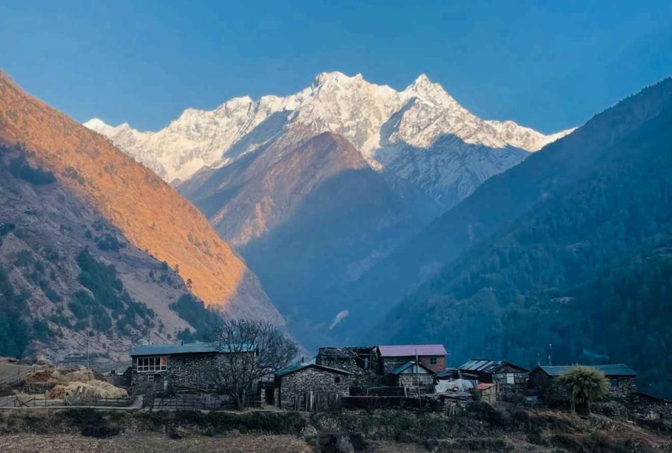
The Manaslu Circuit Trek is one of the most rewarding and least commercialized high-altitude trekking routes in Nepal. Circling Mount Manaslu at 8,163 m and crossing Larkya La Pass at 5,160 m, it covers roughly 177 km of trail over 14 to 18 days, passing through six ecological zones and cultures that range from Gurung villages in the subtropical lowlands to Tibetan Buddhist communities near the border with Tibet.
Questions about this trek fall into consistent categories. Trekkers want to know how hard it is, whether beginners can handle it, what happens if altitude sickness strikes, what the tea houses are actually like, whether Wi-Fi and charging are available, what to pack, how the road to the trailhead behaves, and whether it is safe for women trekking solo or in small groups.
This guide answers all of those questions from the field experience of our team at Manaslu Treks and Expedition. We have guided groups on this circuit across all seasons. The answers here are practical and specific, not reassuring generalities.
Manaslu Circuit Trek Difficulty
The Manaslu Circuit is rated moderate to strenuous. That rating places it above the Everest Base Camp trek in overall physical demand by most experienced guides, and roughly comparable to it in altitude. The reasons are specific.
The trail covers approximately 177 km over 14 to 18 days, with daily walks averaging 15 to 20 km and 6 to 8 hours of active trekking. There are no road shortcuts once you enter the restricted zone at Jagat. If you need to turn back above that point, you walk back. The terrain involves sustained altitude gain, steep descents, river gorge traversals, and the demanding Larkya La Pass crossing at 5,160 m on a single consecutive day of 8 to 10 hours walking.
What Makes It Harder Than Most Treks
Several factors combine to push the difficulty beyond a standard high-altitude route. The remoteness above Samagaun means there are no bail-out vehicle options for ten consecutive days of trail. Tea house facilities become progressively more basic as you gain altitude. Cumulative fatigue from consecutive long days at altitude has a compounding effect. The Larkya La approach begins at 4:00 to 4:30 AM and requires sustained effort over glacial moraine terrain in pre-dawn cold.
The trek is non-technical. No ropes, no ice axes, no climbing skills required. The difficulty is physical and cardiovascular, not mountaineering. By the time you reach Larkya La at 5,160 m, the air pressure is approximately 50 percent of what it is at sea level. Every physical effort feels significantly harder than at normal elevation regardless of your fitness level.
| Aspect | Rating | Details |
|---|---|---|
| Daily walking hours | 6 to 8 hours | Some days shorter (Samdo to Dharamsala); pass day 8 to 10 hours |
| Maximum altitude | 5,160 m | Larkya La Pass; 50% of sea-level oxygen available |
| Technical skills required | None | No ropes, climbing gear, or special technique needed |
| Trail surface | Variable | Stone paths, moraine, river gorge, suspension bridges |
| Bail-out options above Jagat | Very limited | No roads; descent on foot or helicopter evacuation only |
| Prior experience needed | Recommended | Multi-day trekking above 3,000 m strongly recommended prior |
| Fitness level | Good to very good | Must comfortably walk 6+ hours daily on uneven terrain |
Is the Manaslu Circuit Trek Suitable for Beginners?
The honest answer is: yes, with the right preparation, but no without it. The Manaslu Circuit Trek is not the best first Nepal trek for someone who has never done multi-day high-altitude hiking. But a fit, motivated first-time high-altitude trekker who trains properly, chooses a 16 to 18 day itinerary with proper acclimatization days, and treks with an experienced licensed guide can complete this circuit successfully.
The key factors that determine success for a beginner on this route are: physical fitness before arrival, itinerary length (never compress below 14 days; 16 to 18 is better for first-timers), willingness to listen to your guide’s acclimatization advice without debate, and realistic expectations about daily comfort levels.
What Beginners Need to Know Before Booking
- Train for at least 8 to 10 weeks before the trek: long walks (3 to 5 hours), stair climbing, and cardiovascular exercise three to five times per week.
- Break in your boots properly before arriving in Nepal. Blisters at altitude are a genuine problem that reduces your ability to maintain pace.
- The mandatory licensed guide is not a bureaucratic formality. For a beginner, your guide is the person who reads your altitude symptoms before you notice them yourself, makes the pace decisions, and handles every logistical problem that arises.
- Plan a 16-day itinerary minimum. The standard 14-day circuit is achievable for experienced trekkers. For beginners, the extra days at Samagaun and Samdo are not optional rest but necessary physiological adaptation time.
- Do not attempt this trek solo under any circumstance. The restricted area rules require a licensed guide, and that rule exists for the right reasons.
The most common beginner mistake on this circuit is underestimating the cumulative fatigue factor. Day 1 and Day 2 feel manageable. By Day 8 at Samagaun, you have been walking 6 to 8 hours daily for a week at progressively higher altitude. The acclimatization rest day at Samagaun is not a luxury. It is the day your body catches up to where you have been asking it to perform. Guides who eliminate that day to shorten the trip are reducing your safety margin, not your downtime.
Altitude Sickness on the Manaslu Circuit Trek
Altitude sickness is the single most significant health risk on the Manaslu Circuit. The route climbs from 700 m at Soti Khola to 5,160 m at Larkya La Pass. That is a vertical gain of over 4,400 m. At the pass, atmospheric pressure means each breath delivers approximately 50 percent of the oxygen available at sea level. No amount of fitness prevents this. Altitude sickness affects marathon runners and first-time hikers equally. The only variable you control is acclimatization.
Studies on comparable high-altitude treks show that 40 to 60 percent of trekkers above 3,500 m experience mild Acute Mountain Sickness (AMS). The Manaslu Circuit carries a similar statistical risk. The difference from other routes is that above Samagaun, there are no motor roads and therefore fewer immediate bail-out options. A helicopter evacuation from Samagaun (3,530 m) costs USD 3,000 to 5,000 and is weather-dependent.
Three Levels of Altitude Sickness
Mild AMS
- Persistent headache
- Nausea or loss of appetite
- Fatigue beyond normal tiredness
- Poor sleep quality
- Mild dizziness
Action: Stop ascending. Rest. Hydrate. Do not ascend until all symptoms clear.
Moderate AMS
- Severe headache unrelieved by pain relief
- Vomiting
- Extreme fatigue
- Reduced coordination
- Confusion
Action: Descend 300 to 500 m immediately. Do not delay overnight.
Severe AMS / HAPE / HACE
- Breathlessness at rest
- Persistent cough (frothy)
- Cannot walk straight
- Loss of consciousness
- Blue lips or fingernails
Action: Immediate descent and emergency evacuation. Life-threatening.
Prevention: What Actually Works
- Ascend gradually. Above 3,000 m, do not increase your sleeping altitude by more than 300 to 500 m per night.
- Drink 3 to 4 liters of water daily. Dehydration accelerates AMS symptoms. Hot drinks count toward your fluid intake.
- Avoid alcohol above 3,000 m. Alcohol suppresses breathing and causes dehydration, both of which worsen altitude symptoms.
- Climb high, sleep low. On acclimatization days, hike to higher altitude during the day, then return to a lower elevation to sleep. The standard acclimatization hike from Samagaun to Manaslu Base Camp at 4,800 m before sleeping again at 3,530 m is a perfect example.
- Diamox (acetazolamide). A prescription medication that aids acclimatization. Consult your doctor before the trek about dosage. Standard recommendation is 125 mg twice daily starting 24 hours before ascending to altitude. It does not replace acclimatization days.
- Communicate symptoms to your guide immediately. Never hide altitude symptoms. Your guide has seen AMS many times and will read the situation accurately.
Never ascend when you have AMS symptoms. This rule saves lives. A descent of just 300 to 500 m usually stops AMS progression within hours. Trekkers who push through worsening symptoms create emergencies. Trekkers who descend promptly almost always recover quickly and complete the trek successfully after a recovery day.
Acclimatization in Manaslu: How the Schedule Works
The Manaslu Circuit Trek itinerary builds in two mandatory acclimatization days. These are not rest days in the sense of lying in your tent. They are structured “climb high, sleep low” days that train your body to function at progressively higher oxygen levels.
| Acclimatization Point | Altitude | Recommended Activity | Why It Matters |
|---|---|---|---|
| Samagaun (first night) | 3,530 m | Rest and easy walking in village | First significant altitude stop after rapid gain from lower trail |
| Samagaun (rest day) | 3,530 m | Hike to Birendra Lake (3,460 m) or Manaslu Base Camp (4,800 m) | Climb high, sleep low. The Base Camp hike is the best acclimatization exercise on the entire circuit. |
| Samdo (extra night) | 3,875 m | Optional day hike toward Tibetan border | The most underestimated acclimatization step. Many shortened itineraries skip this. Do not skip it. |
| Dharamsala | 4,460 m | Rest only; no strenuous movement | Pre-pass sleep altitude. The pass crossing the next morning requires full energy reserves. |
The climb from Samdo (3,875 m) to Larkya La (5,160 m) happens over two days: Samdo to Dharamsala, then the pass crossing. That is a 1,285 m gain in sleeping altitude in 48 hours. Without the Samagaun and Samdo acclimatization days preceding it, this ascent rate is medically reckless. With those days properly used, the body has had sufficient time to produce the additional red blood cells and respiratory adaptations needed for that final climb.
Budget itineraries that eliminate the Samdo night to shorten the trek from 16 days to 13 are a genuine safety risk. The USD savings on two fewer days are not worth the dramatically higher AMS probability on the pass crossing day. Our team at Manaslu Treks and Expedition will not offer an itinerary that compresses this section below medically sound timing.
Manaslu Tea Houses: What to Realistically Expect
Accommodation on the Manaslu Circuit is entirely in locally run tea houses. There are no mid-range or luxury lodges on this route. The quality, comfort, and facilities available change significantly with altitude.
Lower Section Tea Houses (Jagat to Namrung, 1,340 m to 2,630 m)
Tea houses in the lower Budhi Gandaki gorge section are the most developed on the circuit. Rooms are basic twin-share with foam mattresses, sheets, and blankets. Attached bathrooms are available at some lodges. Hot showers (solar-heated) typically cost NPR 300 to 500 (approximately USD 2.50 to 4). Electricity for charging is available at most lodges at NPR 200 to 300 per device. Wi-Fi is patchy but available at some lodges for NPR 200 to 400 per session.
Mid Section Tea Houses (Lho to Samagaun, 3,180 m to 3,530 m)
Tea houses become smaller and more family-run. Rooms are twin-share with thin blankets; bring your own sleeping bag rated to at least minus 10 to minus 15 degrees Celsius. Hot showers are available at Lho and sometimes at Samagaun but not guaranteed. Charging costs increase to NPR 400 to 500. Wi-Fi becomes unreliable and expensive. Dal bhat dominates the menu. Generators and solar panels power the facilities. Prices for all services are higher due to the cost of mule-transported supplies.
Upper Section Tea Houses (Samdo to Dharamsala, 3,875 m to 4,460 m)
Dharamsala is the pre-pass camp. The lodge here is very basic: simple twin rooms, extremely thin walls, minimal heating. Night temperatures drop to minus 5 to minus 10 degrees Celsius. The blankets are inadequate without a proper sleeping bag. Charging may or may not be available depending on the solar system status (cost NPR 500 or more when available). No reliable Wi-Fi. This is not the place to expect comfort. It is the place to arrive, eat, and sleep before the 4 AM start.
| Section | Room Quality | Hot Shower | Charging Cost | Wi-Fi | Shared Toilet |
|---|---|---|---|---|---|
| Jagat to Namrung | Moderate | Usually available | NPR 200 to 300 | Patchy | Mix of private/shared |
| Lho to Samagaun | Basic | Sometimes available | NPR 400 to 500 | Unreliable | Usually shared |
| Samdo to Dharamsala | Very Basic | Not available | NPR 500+ if available | None | Shared |
| Bimtang to Dharapani (post-pass) | Basic improving | Varies | NPR 300 to 500 | Patchy | Mostly shared |
Bring a sleeping bag liner in addition to your sleeping bag. On cold nights at Samdo and Dharamsala, you will want every layer of warmth available. Tea house blankets at altitude are genuinely insufficient. Also: bring a microfiber towel, as shared towels in remote lodges are unhygienic. Earplugs are worth packing for shared dining rooms where other trekker groups’ schedules may not align with yours.
Food on the Manaslu Trek: What You Will Eat
All meals on the Manaslu Circuit Trek are served at tea house lodges. No camping meals, no self-catering. The food is simple, calorie-dense, and generally well-suited to the physical demands of the trek. Quality varies by altitude; the lower sections offer more menu variety, while the upper sections revolve almost entirely around a small set of reliable dishes.
Food Prices by Altitude
All food on the Manaslu Circuit is transported by mule, porter, or yak. The further up the trail, the higher the cost of every item. A dal bhat that costs NPR 500 at Machha Khola costs NPR 1,000 or more at Dharamsala. This is not inflation or price gouging. It reflects the real logistics cost of getting food to remote high-altitude locations.
| Meal | Lower Section (to 2,000 m) | Mid Section (2,000 to 3,500 m) | Upper Section (3,500 m+) |
|---|---|---|---|
| Dal Bhat (full meal) | NPR 400 to 600 | NPR 600 to 900 | NPR 900 to 1,200 |
| Noodle soup | NPR 250 to 400 | NPR 400 to 600 | NPR 600 to 800 |
| Eggs (2, any style) | NPR 200 to 300 | NPR 300 to 450 | NPR 400 to 600 |
| Hot drink (tea, coffee) | NPR 80 to 150 | NPR 150 to 250 | NPR 250 to 400 |
| Bottled water (1 liter) | NPR 100 to 150 | NPR 150 to 250 | NPR 300 to 500 |
Bottled water at high altitude is expensive and creates significant plastic waste. We strongly recommend bringing a water filter bottle or purification tablets and using boiled water from tea houses (NPR 50 to 100 per liter). This is both environmentally responsible and significantly cheaper on a 14 to 18 day trek.
Appetite typically decreases above 3,500 m. Eat even when you do not feel hungry. Calorie deficit at altitude accelerates fatigue. Dal bhat with its unlimited refill policy is specifically well-suited to high-altitude trekking: carbohydrate-rich, warm, and easy to eat small portions frequently.
Internet and Charging on the Manaslu Trek
Many trekkers come to the Manaslu Circuit expecting reasonable connectivity. The honest picture is that this is one of the least connected trekking routes in Nepal, and that is substantially part of its appeal. Understanding the specifics helps you prepare correctly.
Mobile Network Coverage
The best mobile network for this route is Nepal Telecom (NTC), which has significantly better coverage in the Manaslu region than Ncell. Purchase an NTC SIM card in Kathmandu before departure. Both networks provide 3G and sometimes 4G coverage in the lower sections of the trail (to approximately Jagat), after which coverage becomes patchy and primarily limited to calls and text.
| Location | NTC Coverage | Ncell Coverage | Wi-Fi Available | Charging Available |
|---|---|---|---|---|
| Soti Khola to Jagat | Good (3G/4G) | Good | Yes (fee) | Yes (NPR 200 to 300) |
| Deng to Namrung | Patchy | Poor | Some tea houses | Yes (NPR 300 to 400) |
| Lho to Samagaun | Intermittent | Very poor | Unreliable | Solar (NPR 400 to 500) |
| Samdo | Limited | None | Very limited | Solar when available |
| Dharamsala | None to minimal | None | None | Rarely available (NPR 500+) |
| Bimtang to Dharapani | Improving | Patchy | Some tea houses | Yes (NPR 300 to 400) |
Charging Strategy
The practical solution is a high-capacity power bank of at least 20,000 mAh. Charge it fully in the lower sections of the trail where electricity is reliable and affordable. Above 3,500 m, treat charging opportunities as occasional bonuses rather than daily expectations. Keep your power bank in your sleeping bag at night above 4,000 m; cold temperatures dramatically reduce battery capacity.
A lightweight solar charger is useful on sunny days during the pass approach but unreliable in cloud conditions. Do not plan your safety communication around solar charging alone.
Above Samagaun, do not rely on mobile phones for emergency communication. Confirm with your trekking agency before departure that your guide carries a satellite phone or has access to one. Some tea houses along the upper circuit have landline or satellite phone service for emergency use. Your guide will know which ones. This is one reason the mandatory licensed guide requirement has genuine safety value, not just regulatory function.
Jeep Road Conditions: Kathmandu to the Manaslu Trailhead
The drive from Kathmandu to the trailhead at Soti Khola or Machha Khola covers approximately 140 to 160 km and takes 7 to 9 hours in good conditions. This is one of the logistical factors that distinguishes the Manaslu Circuit Trek from other Nepal trekking routes.
The route passes through Malekhu, Arughat Bazaar, and then follows the Budhi Gandaki valley. The road is asphalted to Arughat, after which it becomes an unpaved jeep track. From Arughat onward, the road requires a 4WD vehicle. In dry conditions (spring and autumn), a well-maintained jeep completes this section without major difficulty, though the road is genuinely rough with frequent river crossings and sections where the track sits above exposed riverbanks.
| Season | Road Condition | Estimated Drive Time | Risk Level | Vehicle Required |
|---|---|---|---|---|
| October to November (peak autumn) | Dry, manageable | 7 to 9 hours | Low | Private 4WD jeep |
| March to May (spring) | Generally good; occasional rain | 7 to 9 hours | Low | Private 4WD jeep |
| Late September | Damp; mostly passable | 8 to 10 hours | Moderate | Private 4WD jeep |
| June to August (monsoon) | Wet; active landslide risk | 10+ hours or impassable | High | Private jeep; may fail |
| December to February | Dry but cold | 8 to 10 hours | Low to moderate | Private 4WD jeep |
Public Bus vs Private Jeep
Public buses from Kathmandu’s Gongabu Bus Park run daily to Arughat and sometimes Soti Khola, departing at 6:00 AM to 8:00 AM. Cost is approximately NPR 700 to 1,200 per person versus NPR 6,000 to 12,000 for a private jeep. The bus option is significantly slower, less comfortable, and more susceptible to delays. For a trek with 14 to 18 demanding days ahead, arriving at the trailhead exhausted after a 12-hour bus journey is not a sound start.
Private jeep transport is included in most Manaslu trekking packages. If you are booking independently, confirm the jeep directly with your agency. Do not assume a shared local jeep will operate on your schedule. The section between Arughat and Machha Khola is where most delays occur, and in monsoon season, this section can be cut off by landslides for multiple days.
Manaslu Circuit Trek Packing List 2026
Packing for the Manaslu Circuit requires thinking in layers and anticipating both subtropical heat at 700 m and arctic conditions at 5,160 m. Do not bring cotton. Cotton absorbs moisture and dries slowly, which becomes dangerous at altitude. The layering system: moisture-wicking base layers, insulating mid-layer, and waterproof outer shell is standard and non-negotiable.
Clothing and Footwear
- Waterproof trekking boots (broken in well before the trek)
- Camp sandals or lightweight shoes for tea houses
- 5 to 7 pairs merino wool or synthetic trekking socks
- Thermal base layers top and bottom (2 sets)
- 2 to 3 moisture-wicking long-sleeve shirts
- Fleece mid-layer jacket
- Down jacket rated to minus 15°C minimum
- Waterproof shell jacket (Gore-Tex or equivalent)
- Waterproof trekking trousers
- Trekking trousers (2 pairs; one convertible is useful)
- Warm hat or beanie
- Sun hat with brim
- Balaclava (essential for Larkya La in October and November)
- Liner gloves plus warm outer gloves
- Gaiters (for mud and November snow)
Sleeping and Shelter
- Sleeping bag rated to minus 10 to minus 15°C
- Sleeping bag liner (adds warmth; improves hygiene in tea houses)
- Microfiber travel towel (small and large)
- Earplugs (shared tea house common rooms)
- Eye mask for early sleep before the pass day
Gear and Navigation
- 50 to 70L main duffle bag (porter carries this)
- 30 to 40L daypack with rain cover
- Trekking poles (collapsible; reduces knee strain on descents)
- Headlamp plus spare lithium batteries (4:00 AM Larkya La start)
- Power bank 20,000 mAh minimum
- NTC SIM card (purchased in Kathmandu)
- Offline map downloaded before departure (Maps.me or Gaia GPS)
- Reusable water bottle 1.5 to 2 liters
- Water purification tablets or filter bottle
- Sunscreen SPF 50+ (UV intensity is high at altitude)
- Lip balm with SPF
- Sunglasses with UV protection
Health, Safety and Documents
- First aid kit: bandages, antiseptic, pain relief, anti-diarrhea, blister treatment
- Pulse oximeter (monitor blood oxygen saturation daily above 3,500 m)
- Diamox (acetazolamide) — prescription; consult doctor before trek
- Personal medications plus generous extra supply
- Rehydration salts or electrolyte powder
- Anti-nausea medication
- Passport (original; required for permit checkpoints)
- Copies of all permits (agency provides)
- Travel insurance documents (helicopter evacuation coverage required)
- Cash in Nepalese Rupees NPR 20,000 to 30,000 minimum (no ATMs on trail after Arughat)
- Passport photos 4 to 6 copies
Women-Specific Items
- Sanitary products for full duration (unavailable on trail)
- Menstrual cup (recommended for environmental and practical reasons)
- Biodegradable wet wipes
- Feminine hygiene wash in travel size
- Extra underwear (merino wool dries fastest)
- Personal alarm or whistle
- Quick-dry sports bras (3 minimum)
What Not to Bring
- Anything made of cotton (retains moisture and weight)
- Jeans or heavy denim
- New boots that have not been broken in
- More than one book (use an e-reader)
- Excess toiletries (travel sizes only)
- Drone (restricted area; not permitted)
- Laptop (heavy; unnecessary; tea house Wi-Fi insufficient anyway)
- Perfume or strong scents (offensive in Buddhist monastery communities)
Most trekking gear including sleeping bags, down jackets, trekking poles, and gaiters can be rented in Thamel, Kathmandu for USD 1 to 3 per day per item. If you do not own high-quality cold-weather gear, renting in Kathmandu is often more practical and affordable than purchasing at home. Your agency can advise on reliable rental shops and will verify your gear the day before departure.
Female Trekkers on the Manaslu Circuit: Safety, Practicalities and Honest Advice
The Manaslu Circuit is one of Nepal’s safest trekking routes for female trekkers, including those traveling solo or in small groups. Nepal consistently ranks as one of the most welcoming countries in the world for women travelers. The mountain communities of the Manaslu region are particularly respectful: many lodges in the upper valley are run by local women, and the Tibetan Buddhist communities treat trekkers of all genders with the same warm formality.
The mandatory licensed guide requirement, which has been in place for the Manaslu restricted area since the route opened, provides an additional layer of safety that does not exist on open trekking routes. Your guide is physically present throughout the trek. This eliminates the vulnerability that comes from navigating remote trails alone in any country.
March 2026 Solo Trekking Update
As of March 22, 2026, Nepal’s Department of Immigration removed the previous requirement of a minimum of two trekkers for Manaslu restricted area permits. Solo trekkers, including solo women, can now apply for permits independently through a registered agency with a single licensed guide. This makes the trek accessible to anyone who wants a private guided experience without finding a trekking partner.
Choose a Reputable Agency and Ask About Female Guides
Request a female guide when booking if you prefer one. Female-licensed trekking guides are increasingly available in Nepal. Some female trekkers specifically request female guides for added comfort during personal hygiene matters on the trail. Ask your agency at the time of booking.
Dress Modestly Through Buddhist Villages
In upper valley villages like Samagaun and Samdo, cover shoulders and knees. Long trekking trousers rather than shorts show respect for local culture. At monastery visits, remove footwear and cover your head with a scarf. These customs are not negotiable expectations; they are simple signs of respect that local communities genuinely appreciate.
Menstrual Health on the Trail
Plan for the full trek duration and bring supplies from Kathmandu. Menstrual products are not available on the trail. A menstrual cup is the most practical option for an 18-day trek. Pack biodegradable disposal bags for used products; do not leave any waste on the trail or at tea houses. Hot water bottles at tea houses provide effective heat therapy for cramps. Inform your guide if you need a slower pace on particularly uncomfortable days.
Personal Security at Tea Houses
The Manaslu region has an excellent safety record for trekkers of all backgrounds. The most practical precautions: keep your room locked, store valuables in your daypack rather than leaving them in your room, and carry your passport and permit copies in a separate waterproof pouch from the originals.
The Trekking Community on the Trail
Even in the relatively quiet Manaslu region, you will encounter other trekkers at tea houses, particularly in October. The international trekking community on this route is supportive and welcoming. Many solo female trekkers find organic group connections form within the first few days of the trail. Your guide is both a safety resource and a cultural bridge between you and the communities you pass through.
Basic Nepali for Female Trekkers
Learning a few basic Nepali phrases makes a significant positive difference: Namaste (greetings), Dhanyabad (thank you), Tadha Jau (go away, if needed), and Sathi xa? (is there a friend nearby?) are genuinely useful. Local women running tea houses often respond warmly to female trekkers who show cultural interest and basic language courtesy.
Manaslu Weather by Month: Full Year Guide
Understanding the Manaslu Circuit Trek weather by month is essential for choosing the right trekking window in 2026. The region spans six climatic zones, and weather conditions change dramatically with altitude. The temperatures listed below reflect the range from lower trail sections (700 to 1,400 m) to the high-altitude upper sections (3,500 to 5,160 m).
| Month | Low Alt Day Temp | High Alt Night Temp | Visibility | Trail Condition | Recommendation |
|---|---|---|---|---|---|
| January | 8 to 14°C | -15 to -20°C | Clear but cold haze | Larkya La snow; frozen | Experts only |
| February | 10 to 16°C | -12 to -18°C | Improving | Heavy snow at pass | Experts only |
| March | 15 to 18°C | -6 to -10°C | Good; improving | Residual snow at pass; lower trail clear | Possible with preparation |
| April | 18 to 22°C | -2 to -5°C | Excellent | Good; rhododendrons blooming | Highly recommended |
| May | 20 to 24°C | 0 to -3°C | Good morning; cloud builds PM | Good; pre-monsoon building late May | Recommended |
| June | 22 to 26°C | 5 to 8°C | Poor (monsoon) | Wet; leeches; landslide risk | Not recommended |
| July | 24 to 28°C | 8 to 12°C | Very poor | Active landslides; road risk | Avoid |
| August | 23 to 27°C | 7 to 10°C | Very poor | Heaviest monsoon; most dangerous | Avoid |
| September | 18 to 24°C | 2 to 5°C | Clearing from 3rd week | Damp early; dries fast from Week 3 | Good from late September |
| October | 15 to 20°C | -5 to -8°C | Excellent (90%+ clear days) | Dry, well-maintained throughout | Best month overall |
| November | 10 to 16°C | -8 to -12°C | Excellent to very good | Dry; cold at high altitude | Recommended |
| December | 8 to 14°C | -10 to -15°C | Clear and crisp | Snow building above 4,500 m | Experts only |
The Two Best Windows in 2026
October (first choice): Post-monsoon air is the clearest of the year. Larkya La is snow-free in early to mid-October. Tea houses are fully open. Temperatures are cold at altitude but manageable with proper gear. This is when the south face of Manaslu is at its most visible and photogenic from Samagaun.
April (second choice): Rhododendron forests in the lower trail sections are in full bloom from late March through April. Monastery festivals in Tsum Valley are active. Permit costs are lower (USD 75 per week versus USD 100 in autumn). Slightly fewer trekkers than October. The Larkya La still carries consolidated snow in April but is manageable with experienced guidance.
For a complete month-by-month breakdown with temperature data and trail condition specifics, read our detailed Manaslu Circuit Trek weather guide.
Planning Summary for 2026
The Manaslu Circuit Trek is an exceptional journey for the right trekker. The practical information in this guide covers the most common questions we receive from clients before they depart. Every section reflects field knowledge from years of operating this route, not research assembled from other sources.
To summarize the key practical points:
- The trek is moderate to strenuous. Plan a minimum of 14 days, 16 to 18 for beginners or those who prioritize safety margins.
- Altitude sickness is the primary health risk. Never ascend with symptoms. Acclimatization days at Samagaun and Samdo are medically non-negotiable.
- Tea houses are basic above 3,500 m. Bring a sleeping bag rated to minus 15°C and do not rely on tea house blankets alone.
- Food is simple, sufficient, and calorie-rich. Dal bhat is your best choice at any altitude. Bring cash; no ATMs exist on trail above Arughat.
- Wi-Fi and charging are unreliable above 3,000 m. Bring a 20,000 mAh power bank and charge devices fully in lower villages.
- The jeep road from Kathmandu is manageable in spring and autumn, rough but reliable. Avoid planning this trek in monsoon season primarily because of road and trail conditions.
- Female trekkers: Nepal and the Manaslu region are safe and welcoming. The mandatory guide provides a significant practical safety layer. Solo women can now obtain individual permits as of March 2026.
- October is the best month. April is the best alternative.
For booking, permit logistics, current trail conditions, or to plan your Manaslu Tsum Valley Trek, contact our team directly. We operate this circuit across all seasons and handle every logistical detail from Kathmandu so you can focus entirely on the mountains.
Plan Your Manaslu Circuit Trek With Local Experts
We handle permits, licensed guides, jeep transport, tea house bookings, and all logistics. You show up. We make the mountains happen.
Talk to Our TeamManaslu Treks and Expedition | Registered Nepal Trekking Operator | Kathmandu