
By Kiran Basnet, Licensed Trekking Guide and Founder, Manaslu Treks and Expedition
Most people who find us are sitting somewhere on the other side of the world, searching for a Manaslu circuit trek company they can actually trust. They read a few reviews, visit a few websites, check prices, and then start wondering: what actually happens after I click “contact”? Who answers? How does this all work? What will every single day look like?
I get these questions constantly. So I am going to walk you through the entire experience, from the moment you find us online to the moment the return jeep drops you back in Kathmandu. Every village, every trail section, every teahouse, every morning routine. Nothing left out.
I grew up in Dhading district, which sits right at the gateway to the Manaslu region. I have completed the Manaslu Circuit Trek over 20 times as a licensed guide. When you book with Manaslu Treks and Expedition, you are not booking through a middleman or an online platform with a call center. You are talking directly to the person who has walked this trail more times than he can count and who will walk it with you.
Before the Trek Begins: How We Work Together
Step 1: You Find Us and Send a Message
It starts with a search. Maybe you type “Manaslu circuit trek company Nepal” or “Manaslu trek Nepal” into Google. Maybe a friend who trekked with us recommends us. However you arrive, welcome.
Once you are on our website, you can send a message through the contact form, email us at info@manaslutreks.com, or reach us on WhatsApp at +977 9869225929. WhatsApp is the fastest. I personally manage all client communications, and I respond to every message, usually within a few hours. There are no automated replies here. No chatbot. When you message us, a real person from our team answers with real information about your actual situation.
When you write to us, please include your tentative travel dates, the number of people in your group, the trek package that interests you, and your trekking experience. That gives me enough to start planning properly from the first reply.
Step 2: We Answer Every Question You Have
People ask us everything. How hard is Larkya La Pass really for someone with no prior high-altitude experience? What does the food taste like in a teahouse at 4,000 meters? Can I rent trekking poles in Kathmandu, or should I bring my own? What happens if the weather closes in above Dharamsala? Is it safe to trek after a knee surgery? What is the bathroom situation like in the higher villages?
We answer all of it. We never rush you toward booking. Some clients take two weeks of message exchanges before they feel ready to confirm, and that is completely fine. By the time you book with us, you should already feel like you know what you are getting into.
Step 3: You Confirm Your Travel Dates
Once you are satisfied and ready to commit, we lock in your travel dates together. We always discuss the best timing based on your window. Spring (March to May) and autumn (September to November) are the two main trekking seasons on the Manaslu circuit. We tell you honestly if we think a particular window has risks. Early March can still have heavy snow on Larkya La. Late November above Dharamsala gets very cold at night. We give you the real picture, and then you decide.
No advance payment is required to confirm your booking. This is our policy, and it has been since we started. You pay upon arrival in Nepal. You meet us, meet the guide, feel confident about everything, and then pay. We know that sending money overseas to a company you have never met is a significant act of trust, and we do not ask you to do that.
Step 4: You Send Your Passport Copy and Flight Details
Once dates are confirmed, we need two things from you: a scanned copy of your passport information page and your flight arrival details. The passport is needed to begin the permit applications. The Manaslu Circuit Trek requires three permits: the Manaslu Restricted Area Permit (RAP), the Manaslu Conservation Area Permit (MCAP), and the Annapurna Conservation Area Permit (ACAP). Starting the permit process before you fly means everything is ready the moment you land.
Your flight details tell us when to have someone at the airport for you.
Step 5: Airport Pickup and Hotel Check-In
When your flight lands at Tribhuvan International Airport in Kathmandu, one of our team members will be waiting in the arrivals hall with a sign bearing your name. We arrange private transport from the airport directly to your hotel in Thamel. If your flight is delayed, we track it. If there is a problem with immigration, we are there.
Your accommodation in Kathmandu is included in the package. You stay at the Moonlight Hotel in Thamel, which is centrally located, clean, comfortable, and a five-minute walk from most of the gear shops, restaurants, currency exchange offices, and pharmacies in the area. The hotel is included in your package price. It is not an additional cost.
Thamel is the starting point of every Nepal trekking adventure. Spend the afternoon settling in, walking around the neighborhood, finding a good restaurant for dinner, and resting after your journey.
Step 6: The Pre-Trek Briefing, Gear Handover, and Guide Introduction
The evening of your arrival or the following morning, depending on your flight time, we sit down together for your pre-trek briefing. This is a meeting I put a lot of care into.
We go through the entire itinerary day by day. We talk about what each section of the trail actually looks like, the daily elevation gain, the symptoms of altitude sickness to watch for, how the permit checkpoints work, and what to expect from the teahouses at each stage. We review the gear we are handing over to you, which includes a sleeping bag and a down jacket for the full duration of the trek. If you need micro spikes for the Larkya La crossing, we sort that out here, too.
You also meet your guide. I introduce you personally whenever possible. The guide who meets you here is the same one who will walk with you from Machhakhola to Dharapani. There is no handoff. The guide speaks fluent English, has first aid training, knows every teahouse owner along the circuit personally, has crossed Larkya La Pass many times, and genuinely cares about whether you enjoy the trek.
The guide handles the morning briefing in the evenings. The guide handles all checkpoint procedures for your permits. The guide handles every logistical detail so that your only job on the trail is to walk, look at the mountains, and enjoy it.
Step 7: Payment
Payment happens after the briefing, once you have met everyone and are comfortable. You can come to our office in Thamel, or we will come to your hotel to collect payment. We accept cash in Nepali Rupees or US Dollars. No online transfer, no advance deposit, no pressure.
Step 8: We Provide Your NTC SIM Card
We provide an NTC SIM card that offers mobile data coverage from Kathmandu to most trekking villages on the circuit. The signal is strong in the lower and middle sections of the trek. Above Dharamsala, connectivity becomes very limited in sections, which is normal at that altitude. For most of the trek, you will be able to stay in touch with family and upload the occasional photo.
The Drive to the Trailhead: Kathmandu to Machhakhola
The Morning of Departure
Your guide and porter arrive at the Moonlight Hotel between 6:30 and 7:00 am. They come to you. You do not need to navigate to a bus park or find a departure point. Have your bags packed before they arrive. The night before, the guide will have reminded you to organize your main bag for the porter and keep a lighter daypack for yourself. The porter needs a few minutes to secure the load, so packing in advance makes the morning go smoothly.
Have breakfast at the hotel before you leave. The Moonlight Hotel serves a proper breakfast, and you will need fuel for the long drive ahead. If you prefer, they can pack your breakfast to take with you. Just tell them the night before.
The bus park is about ten minutes from the hotel on foot. If you have arranged a private jeep, it comes directly to the hotel and your journey begins from your doorstep. I recommend the private jeep for groups of 2 or more people. It is more comfortable, you can stop whenever you want along the route, and it handles the rough road sections far better than the public bus.
Leaving Kathmandu Valley: The First Hour
As you drive out of Thamel and head west through Kathmandu, the city surrounds you on all sides. Traffic is typical of Kathmandu in the early morning: motorbikes threading between larger vehicles, vendors setting up their stalls, the smell of incense from morning prayers mixing with diesel from passing buses.
Within 20 to 30 minutes of leaving the hotel, your route passes Swayambhunath, the temple complex Nepalis call Swayambhu and the rest of the world calls the Monkey Temple. The white dome of the stupa and its gilded spire sit on a wooded hill above the road. The monkeys that live around the complex are usually visible, moving along the stone walls and steps. If you have time on the day before the drive, this temple is worth visiting on foot. If not, seeing it from the vehicle gives you a first taste of Kathmandu’s ancient sacred landscape as you leave it behind.
When Swayambhunath disappears from view behind you, and the road begins its descent toward the Prithvi Highway, you have left Kathmandu Valley. The mental shift happens here. The city is gone. The journey has started.
Prithvi Highway and the Trishuli Valley
The Prithvi Highway runs west from Kathmandu toward Pokhara and is a well-maintained road with decent traffic. The landscape changes immediately once you drop out of the valley. Terraced hillsides appear on both sides; the Trishuli River runs along the road to one side, and the air noticeably improves. The water in the river is a milky green from glacial sediment further upstream.
This section of the drive takes roughly two hours. The road passes through the district of Nuwakot and then Rasuwa on the far side before entering Dhading. Villages line the hillsides above the road, each with its own set of terraced fields cut into the slope.
The First Break Stop
After approximately 2 hours on the highway, the vehicle stops for a 20-minute break before the Malekhu junction. There are small roadside tea shops and basic facilities here. This is your first opportunity to stretch your legs, use the toilet, and have a coffee or tea. It is a simple stop, but everyone is usually ready for it by this point in the drive.
Malekhu: The Famous Fish Town
Malekhu is a small market town where the Malekhu Khola river joins the Trishuli, and it is known throughout Nepal for one thing: fresh fish. Local vendors sell fish, usually fried, straight from the river at stalls along the road. The smell reaches you before you see the stalls. You stop here for 10 to 15 minutes. Whether you try the fish is up to you, but it is one of those small, memorable roadside moments people talk about when they describe the drive. The fish is fresh, the price is low, and eating by the side of a Nepali highway while mountains appear in the distance is a good way to spend fifteen minutes.
Toward Dhading Besi on the Kalanki-Pandey Highway
From Malekhu, the route turns away from the Trishuli and heads south, then east, toward Dhading Besi on the Kalanki-Pandey Highway. The landscape becomes more rural as the main highway is left behind. Villages are smaller and spaced further apart. The hillsides on this section have a more open quality, less forested, with wider views across the valley floors.
Dhading Besi is the headquarters of Dhading district, a proper market town with banks, pharmacies, hotels, restaurants, and all the region’s administrative offices. It is a busy place on market days. The road from Kathmandu to Dhading Besi is almost entirely paved and in good condition. This is the last major town before the landscape turns fully rural and the road begins to deteriorate.
Jyamrung Village and the Ganesh Himal View
Between Dhading Besi and Arughat, the road passes through a village called Jyamrung. On clear mornings, particularly from September through December and again in March and April, the Ganesh Himal range becomes dramatically visible to the north from the area around this village. The peaks are enormous and unexpected at this point in the journey, appearing suddenly above the ridgeline as the road rounds a bend. For many clients, this is the first real glimpse of the world they are heading into, and it usually produces a moment of silence in the vehicle, followed by everyone reaching for their cameras.
The Ganesh Himal range has peaks ranging from 6,000 meters to over 7,400 meters. What you see from Jyamrung is the southern face of the range. In a few days, you will be walking beneath these same peaks on the trail.
Taribesi and the Lunch Stop
About 30 minutes past Jyamrung, the route reaches Taribesi, a small settlement along the Aakhu Khola river. This is typically where we stop for lunch, usually around midday. The tea shops and simple restaurants here serve dal bhat, fried rice, noodles, and soup. Eating by the river with the valley opening ahead of you and mountains growing larger in the distance is a pleasant way to spend 45 minutes to an hour in the middle of a long drive day. Take your time here. Stretch your legs. The road gets rougher from here on.
Arughat Bazar: The Last Proper Town
From Taribesi, it takes approximately 45 minutes to reach Arughat Bazar. Arughat is the last real commercial hub before the Manaslu region becomes genuinely remote. It sits at the confluence of two rivers and has a functioning market, guesthouses, medical facilities, and shops selling trekking supplies. The road from Kathmandu to Arughat is paved or at least well-maintained throughout.
Beyond Arughat, heading north toward Machhakhola, everything changes.
Arughat to Machhakhola: The Rough Road North
This final section of the drive is approximately 24 kilometers and takes between 2.5 and 3.5 hours, depending on conditions. The paved road ends, and the route becomes an unpaved track that follows the Budhi Gandaki river north into the mountains. It is rocky in sections, loose in others, and during and after rain, it can be muddy and slow. The ridgelines on either side have risen sharply, and the valley has narrowed considerably. You are now in the Budhi Gandaki river corridor, and the landscape has the enclosed, dramatic quality that characterizes the entire lower section of the Manaslu circuit.
If you hired a private jeep, the driver handles this section confidently. On a public bus, it is a rough ride, slow and uncomfortable on the unpaved surface. Either way, you arrive in Machhakhola in the late afternoon, typically between 4:00 and 5:30 pm, depending on your departure time in the morning and the number of stops along the way.
Trek Day 1: Machhakhola to Jagat (1,340m)
Distance: approximately 21km | Walking time: 6 to 7 hours
Arriving in Machhakhola
Machhakhola sits at around 869 meters on the banks of the Budhi Gandaki River. After a full day inside a vehicle on increasingly rough roads, stepping out at Machhakhola feels like arriving somewhere completely different from the Nepal you left in Kathmandu. The air is clean and noticeably cooler. The river runs loudly alongside the trail settlement. The valley walls above are forested and steep.
Your guide leads you to the teahouse, where you will spend the night. Most teahouses in Machhakhola have attached bathrooms and hot shower facilities. The hot shower situation on the Manaslu circuit is better than most people expect. A hot shower after the drive is worth taking. You have earned it before you have even walked a step.
The teahouse menu goes beyond trekking basics. You will find dal bhat, pasta, fried rice, momos, various soup options, and a full range of drinks, including tea, coffee, juice, and soft drinks. The teahouse cooking on the Manaslu circuit consistently surprises first-time clients. The food is genuinely good.
In the evening, your guide sits with you after dinner for the first trail briefing. The guide explains the route from Machhakhola to Jagat, provides the timing and distance, and describes the terrain. The guide also reminds you to pack your main bag tonight before you sleep, so the porter can tie and secure the load in the morning without anyone rushing.
Water: at every teahouse from Machhakhola onwards, free unfiltered drinking water is available. Your guide carries purification tablets and will help you treat water whenever you refill your bottle. You do not need to buy bottled water on the Manaslu circuit. It is cheaper and better for the environment to use treated tap water throughout.
Your guide takes your breakfast order in the evening. Tell the guide what you want and when, and the teahouse kitchen will have it ready when you come downstairs in the morning.
The First Morning: Leaving Machhakhola
Breakfast is ready when you come down, between 7:00 and 7:30 am. Whether it is porridge with honey, eggs with toast, Tibetan bread, or a full cooked meal depends on your order the night before. The guide and porter are at the teahouse when you wake up. The porter has already tied the bag and made it ready.
You leave Machhakhola at around 7:30 to 8:00 am.
The Police Checkpoint
Within a few minutes of walking north from the teahouse cluster, you reach the Machhakhola police checkpoint. This is the first permit check of the trek. Your guide presents your Manaslu Restricted Area Permit and the other documents. The checkpoint officers verify the permits, record your details in their logbook, and stamp the paperwork. The process takes about 5 to 10 minutes. You stand nearby and do not need to do anything. The guide handles all checkpoint procedures throughout the entire trek.
The Trail North: Machhakhola to Khorola Besi
For the first hour or so out of Machhakhola, the trail follows the Budhi Gandaki river corridor northward. In the lower section, the Army’s ongoing road construction in the Manaslu region has altered the landscape. The road runs alongside or, in some places, through what was once the old trekking trail. Your guide knows exactly where the trail alternatives exist and takes you on the best available walking route at all times, moving off the road wherever the path allows. Traffic on this road is limited compared to any main highway, but occasional jeeps and trucks do pass. The guide keeps the group safe and walking efficiently.
The Budhi Gandaki River is your constant companion from this point until far into the circuit. The river is fed by glaciers high above and carries enormous power. You will cross it many times on suspension bridges throughout the trek. The sound of the river is the background music of the lower Manaslu circuit.
Khorola Besi
After roughly one hour of walking from Machhakhola, you reach Khorola Besi, a small settlement of a few teahouses and houses along the river. There is a traditional Gurung community here. The Gurung people have lived in this valley for generations. Many are descendants of the families who formed the famous Gurkha regiments. If you want to stop for tea or rest briefly, the teahouses here are welcoming. Otherwise, continue north at your pace.
Tatopani: The Natural Hot Springs
About an hour beyond Khorola Besi, the trail reaches Tatopani. Tatopani literally means “hot water” in Nepali, and the name is accurate. Natural hot spring water surfaces here and has been channeled into basic bathing pools. The water is genuinely hot, not lukewarm, and the setting of a mountain river trail with steam rising from mineral-rich pools is memorable.
If you want to stop and soak for twenty to thirty minutes, do it. Many trekkers do, especially on cooler mornings when the idea of hot water on sore legs before they have even become sore is appealing. There is no strong reason to rush past Tatopani. The day is long enough to allow for a stop here and still reach Jagat at a reasonable hour.
After Tatopani, the trail continues north along the Budhi Gandaki. The forest becomes denser on the hillsides above the trail, and the valley begins to narrow.
Dovan and the Trail Choice
Roughly one hour past Tatopani, the trail reaches Dovan, a small settlement near a point where the valley narrows significantly, and the river drops through a steep gorge. At Dovan, there is a decision point. You can continue on the road corridor, which is reliable in all conditions, or you can take the old trekking trail that climbs through the hillside above the gorge toward Jagat. The guide assesses the condition of the old trail in real time. If it is clear, the old trail is significantly more pleasant than road walking. If there has been a landslide or the trail is blocked, the road is the sensible choice. This decision is made on the day based on actual conditions.
Above Dovan, the Budhi Gandaki descends through impressive rapids visible from the trail below. The valley is at its most dramatic in this section, with near-vertical cliff walls and the river roaring through the gorge below.
The Final Section to Jagat
Whether you take the old trail or the road route from Dovan, the distance to Jagat takes between two and three hours. The trail crosses the Budhi Gandaki on a suspension bridge, climbs through terraced fields and forest, and eventually arrives at the ridgetop village of Jagat. Jagat sits at 1,340 meters on a narrow ridgeline above the river with terraced fields on the slopes below and a main trail lined with teahouses and small shops.
Jagat is also the point of entry into the Manaslu Conservation Area, and there is a checkpoint where permits are checked again. Your guide handles this at every checkpoint throughout the trek.
You arrive in Jagat in the early to mid-afternoon, typically between 2:00 and 4:00 pm. Your room will be ready. The porter delivers your bag to your door. You have the rest of the afternoon to rest, wash, have tea, or sit outside and watch the valley fall away to the south below the village.
In the evening, the teahouse dining room fills with trekkers from different countries eating at neighboring tables. The Manaslu circuit attracts a different type of trekker than the Everest or Annapurna routes: people who have done the popular circuits and are looking for something less crowded, more remote, and more authentic. Dinner conversation in the teahouses is almost always interesting.
The guide briefs you after dinner about Day 2: the route from Jagat to Deng, the terrain, and what time to be ready in the morning. The Budhi Gandaki river is very audible from Jagat, a constant low roar from the gorge below. Most people find it helps them sleep deeply on their first night on the trail.
Trek Day 2: Jagat to Deng (1,860m)
Distance: approximately 19km | Walking time: 6 to 7 hours
This day is the first full immersive trekking day of the circuit and one of the most culturally interesting sections of the lower route. The trail climbs gradually out of the Gurung and Magar heartland and begins the transition toward the Tibetan-influenced communities of the upper Nubri valley.
Jagat to Salleri and Sirdibas
Leaving Jagat, the trail descends slightly from the ridge before picking up the river corridor heading north. The route passes through the small settlement of Salleri, where views open across the Budhi Gandaki valley and the Sringi Himal range becomes visible to the northwest for the first time. There is a checkpoint here as well on some itineraries. Your guide handles it.
From Salleri, the trail continues to Sirdibas, dropping toward the river and passing through a section that experienced significant landslide damage some years ago. The path has been stabilized, but there are sections where you walk through rocky, open terrain, with the scars of old slides visible on the hillside above. The guide walks you through this section safely.
Philim: The First Large Settlement
After crossing a long suspension bridge over the Budhi Gandaki, the trail enters Philim, one of the larger and more prosperous villages in the lower circuit. Philim has a mix of Gurung and Magar inhabitants, and the houses here are more substantial than the smaller trail settlements: slate-roofed, built of white-plastered stone, many with small gardens and terraced fields of millet extending down from the village.
Philim is also the junction point for the Tsum Valley. If you are doing a combined Manaslu Circuit and Tsum Valley trek, this is where the two routes split. For the standard circuit, the trail continues north through Philim and heads toward Deng.
Philim is a good place to stop for a mid-morning tea break. There are several teahouses on the main trail through the village.
Ekle Bhatti and the Agricultural Landscape
Beyond Philim, the trail passes through Ekle Bhatti, a small settlement surrounded by wide terraced fields of millet, barley, and seasonal vegetables. Yaks and buffalo graze on the fields between the cultivated sections, and the agricultural landscape here has a timeless quality. The mountains around you are growing larger with every kilometer walked northward. Ganesh Himal and its associated peaks are now clearly visible to the east on clear days.
The trail crosses another suspension bridge over the Budhi Gandaki, continues along the riverbank, and passes through the small settlement of Chisapani, which is a typical lunch stop for groups on this section.
Arriving in Deng
After Chisapani, the trail continues north through increasingly dense forest, crossing several smaller streams before the final approach to Deng. You cross the Deng Khola, a tributary of the Budhi Gandaki, on a bridge just before entering the village. Deng, also known as Dyang, sits at around 1,860 meters.
Deng is a Gurung village with a strong Tibetan Buddhist influence. This is where you first notice the architecture and culture beginning to shift. You start seeing mani walls, the low stone walls carved with Buddhist prayers that line the trails and village entrances throughout the upper circuit. Chortens appear at the village edges. Prayer flags flutter on rooftops. The valley above Deng is entering Nubri territory, a region that was historically part of Tibet until the 1840s and retains a strong Tibetan cultural identity.
A beautiful waterfall is visible at a short distance from Deng village. The teahouses in Deng are simple but comfortable. Deng sits in a forested section of the valley, and the evening light through the trees is distinctive. Your guide briefs you after dinner about the day to come: Deng to Namrung, the longest and most demanding day of the lower circuit section.
Note on Deng specifically: the attached bathroom rule applies differently here. Deng is the one section of the standard circuit where attached bathrooms may not be available in every teahouse. The guide will advise on the specific teahouse choice on the night. Come prepared with a headlamp for night toilet trips if needed.
Trek Day 3: Deng to Namrung (2,630m)
Distance: approximately 19km | Walking time: 7 to 8 hours
This is the longest day of the circuit in terms of both distance and total walking time. You gain nearly 800 meters of elevation and pass through some of the most culturally significant villages of the middle circuit. Start early, around 7:00 am, and pace yourself through the day.
Deng to Rana: The River Crossing and Climb
Leaving Deng, the trail crosses the Budhi Gandaki on another suspension bridge and begins a climb to the west side of the valley. This crossing marks the beginning of a section where the trail alternates between the two riverbanks throughout the day. The valley walls are steeper here, and the forest is denser: a mix of fir, rhododendron, bamboo, and oak fills the slopes above the trail.
The trail climbs steadily from the river crossing up to a small settlement called Rana. From Rana, there are widening views back down the Budhi Gandaki valley to the south and the first real sense of elevation gain on the trek. The air is noticeably cooler and cleaner than it was in the lower valley.
Ghap Village
From Rana, the trail continues through increasingly spectacular scenery to Ghap, a Tibetan-influenced village surrounded by large mani walls and chortens. The mani walls at Ghap are some of the most impressive on the lower circuit, long stone walls carved with Om Mani Padme Hum and other Buddhist prayers in Tibetan script. The village marks the transition point where Tibetan Buddhist cultural influence becomes dominant and remains so for the rest of the trek northward.
Ghap is a good place for a short rest. There are a few basic teahouses. The views of the river gorge below Ghap and the forested peaks above it are excellent.
Prok Village and the Sringi Himal View
After Ghap, the trail continues to Prok village, which sits on a spur above the main valley and is known as one of the better viewpoints for Sringi Himal (7,155 meters) in the lower circuit. From the right angle near Prok village, the peak sits directly in your line of sight with forested ridgelines framing it below. If the weather is clear, this is a photograph worth stopping for. Prok is also an important junction: a side trail from here leads up to Tsum Valley for those doing the combined route.
The Forest Section to Namrung
From Prok, the trail enters a longer forest section. The trail winds through dense forests of fir and oak, then into rhododendron groves, then into deep bamboo areas that create a tunnel of vegetation over the path. The sound of the river below carries up through the trees, but the visual world is reduced to the trail ahead and the forest walls on either side.
This section can feel long toward the end of a full day of walking. The guide sets a comfortable pace and identifies good rest spots. Stay hydrated through this section and eat your packed lunch at a proper stop.
Eventually, the bamboo and dense forest give way, and the trail begins to open as it approaches Namrung. The first views of the upper valley appear between the trees, wider and more dramatic than anything seen in the lower circuit sections.
Arriving in Namrung
Namrung sits at 2,630 meters and is a substantial village with a row of well-maintained teahouses along the main trail. The altitude here is significant enough that most people notice the slightly thinner air by the end of the walking day. Some feel a mild heaviness in the head or slight shortness of breath on uphill sections. This is a normal acclimatization response, not altitude sickness. Drink plenty of water, eat well, and rest.
The teahouses in Namrung are comfortable. Private rooms are standard here. The views from Namrung include the first close views of the Manaslu massif beginning to appear to the north, and Himalchuli (7,893 meters) to the east. The village’s cultural atmosphere is fully Tibetan Buddhist. Chortens and prayer flags surround the trail through the village.
After dinner, your guide briefs you on the shorter day ahead: Namrung to Lho, a gentler walk with significant altitude gain that is designed to let your body adapt before the higher sections.
Trek Day 4: Namrung to Lho (3,180m)
Distance: approximately 10 to 12km | Walking time: 4 to 5 hours
This is the first deliberately shorter day of the circuit, designed to give your body proper acclimatization time while still making meaningful forward progress. Do not be tempted to push further today. The altitude gain from Namrung to Lho is enough, and arriving in Lho with energy to spare is far better for your health over the coming days than arriving exhausted.
Namrung to Lihi
Leaving Namrung, the trail climbs steeply upward through forested terrain to the village of Lihi at around 2,900 meters. The houses in Lihi are closely packed together and built in the traditional Nubri style: stone walls, flat roofs used for drying grain and herbs, and small wooden windows. The village feels much older and more remote than the Gurung settlements of the lower valley. Around Lihi and Sho, the barley terraces that characterize this elevation zone create a patchwork of color on the hillsides: green in summer, golden in autumn.
The Simnang Himal (7,251 meters) and Naike Peak (5,515 meters) are visible from the approach to Lihi on clear days.
Sho Village
After Lihi, the trail continues to Sho village at approximately 2,960 meters. Sho is a small settlement of stone houses with an increasing number of chortens and prayer flags marking the trail through and around the village. From Sho, there are striking views of Manaslu North (7,157 meters) emerging behind the ridgeline to the north, an early sign of the giant mountain that will dominate the landscape from here to Larkya La Pass and beyond.
The trail between Sho and Lho passes through a landscape that feels genuinely remote. The valley is narrower here, the walls steeper, and the sense of being very far from the rest of the world is significant. For many trekkers, this is the day when the circuit truly begins to feel different from any other trek they have done.
Arriving in Lho
Lho sits at 3,180 meters on the eastern side of the valley above the Budhi Gandaki. It is one of the culturally richest villages on the entire circuit and one of the most important in the traditional Nubri region.
The centerpiece of Lho is the Ribung Gompa, an ancient Buddhist monastery built on a hilltop above the main village. The monastery is active, with resident monks, and the sound of chanting and bells carries down to the village teahouses in the early morning. If you are awake before sunrise, walk up to the monastery. The combination of monks chanting in the early light with Mount Manaslu rising directly behind the monastery roof is one of the most striking images you will encounter on the entire trek. Experienced trekkers who have done many Himalayan routes consistently mention the early morning at Ribung Gompa as one of the lasting impressions of the Manaslu circuit.
From Lho, the view of Mount Manaslu itself is clear and commanding in good weather. The summit at 8,163 meters is the eighth-highest mountain on earth, and what you see from Lho is the southern face, with its glaciers and ice seracs fully visible.
The teahouses in Lho are good. Private rooms, proper beds, clean facilities. The food here is excellent, particularly the fresh dal bhat with locally grown vegetables. Lho sits at the altitude where the dal bhat transition happens on the Manaslu circuit: in the lower villages, the vegetables used are similar to those anywhere in Nepal. In Lho and above, vegetables are grown at high altitude, often including buckwheat, highland spinach, and locally sourced potatoes with distinctive flavors.
Trek Day 5: Lho to Samagaun (3,530m)
Distance: approximately 9 to 12km | Walking time: 5 to 6 hours
This is the day the mountain theatre really opens. The trail from Lho to Samagaun passes through Shyala village and enters the wide upper valley of the Budhi Gandaki, where the landscape changes from forested canyon to open alpine basin. From Shyala onwards, you can see multiple major Himalayan peaks at once and, for the first time, understand the full scale of the mountains surrounding the circuit.
Lho to Shyala
The trail from Lho climbs gradually northwest through the barley terraces above the village before entering a section of open alpine terrain. Prayer flags line the trail, and chortens appear at regular intervals. The morning walk from Lho on clear days is one of the most visually spectacular sections of the circuit.
Shyala sits at approximately 3,575 meters in a wide bowl where several valleys converge. From Shyala, the mountain panorama is extraordinary. Himalchuli (7,893 meters) rises to the east. Ngadi Chuli, also known as Peak 29 (7,871 meters), lies farther along the ridgeline. Ganesh Himal dominates the south-eastern horizon. And ahead, growing steadily larger with every step north, Mount Manaslu’s immense north face fills the head of the valley.
Many trekkers stop at Shyala for a longer rest than planned simply because the view is hard to leave. The guide understands this. There are teahouses in Shyala for tea and snacks.
Approaching Samagaun: The Pungen Gompa Trail
Between Shyala and Samagaun, the trail passes close to the junction for the side route up to Pungen Gompa, the ancient monastery sitting in a high valley above the main trail. If your itinerary includes the acclimatization hike to Pungen Gompa, the guide leads you there on the following day, the rest day in Samagaun. For today, continue the main trail toward Samagaun itself.
As the trail descends slightly into the Samagaun basin, yaks become a regular presence. They graze freely on the open grassland around the upper valley, shaggy and unhurried, completely at home at this altitude. In spring, the grasslands around Samagaun are dotted with wildflowers. In autumn, they are golden and dry.
Arriving in Samagaun
Samagaun is the largest and most developed village on the upper circuit at 3,530 meters. It has more teahouses than any other village above Namrung, and the facilities here are genuinely comfortable by high-altitude standards. Some teahouses in Samagaun now have solar-powered WiFi and 4G mobile signal in good weather, which means you may be able to make a proper video call home from here.
Samagaun is a Nubri village with a strong Tibetan cultural identity. The architecture is distinctly Tibetan: flat-roofed houses, stone walls, Buddhist shrines at every corner. The local community has lived here for generations at this altitude, herding yaks, growing barley and buckwheat, and maintaining the ancient trade connections with Tibet that were the economic backbone of the Nubri region for centuries.
Hot showers are available at most teahouses in Samagaun, usually at an extra cost of around 200-300 Nepali rupees. Charging your devices costs approximately 200 to 500 rupees, depending on what you need to charge. The guide can advise on the best teahouse options for your specific needs.
Trek Day 6: Samagaun Acclimatization Day
No elevation gain required | Options: Birendra Lake, Pungen Gompa, or Manaslu Base Camp
This rest day is not optional. It is a required part of any responsible itinerary at this altitude. Skipping the Samagaun acclimatization day significantly increases the risk of altitude sickness above 4,000 meters. Your body needs this day to produce additional red blood cells and adapt to the lower oxygen levels. The classic rule of high-altitude trekking, climb high and sleep low, means that even though you are resting at Samagaun, you should spend part of the day at a higher elevation before returning to sleep here again.
The guide gives you several options for the day. The choice depends on your energy, your ambition, and the weather.
Option 1: Birendra Lake (3,691m)
Birendra Lake, also called Birendra Tal, is a glacial lake about 45 minutes to one hour above Samagaun at 3,691 meters. The hike up is gentle, and the lake itself is genuinely beautiful: clear water reflecting the mountains and glaciers above, completely still on calm mornings, surrounded by open grassland where yaks graze at the water’s edge.
The lake is named after the late King Birendra of Nepal. On a clear day, it perfectly mirrors Manaslu’s north face. The hike there and back takes around two to three hours, including time at the lake. It is the gentle acclimatization option, suitable for anyone who feels the altitude even slightly or simply wants a relaxed morning.
Option 2: Pungen Gompa (approximately 4,050m)
Pungen Gompa is an ancient monastery set in a high-alpine valley above Samagaun, at approximately 4,050 meters. The hike to reach it takes between two and three hours from the village, depending on pace, and involves significant elevation gain, making it an excellent acclimatization exercise.
The monastery contains ancient Tibetan texts, traditional murals, and Thangka paintings. The resident monks are welcoming to respectful visitors. The valley around the monastery is home to Himalayan wildlife, including blue sheep and yaks, in the high pastures. The Pungen Glacier flows down from the Manaslu slopes above the monastery and is visible from the gompa grounds.
The surrounding alpine landscape at Pungen Gompa is extraordinary. The combination of the ancient monastery, the glacial terrain, the wildlife, and the mountain views makes this the recommended acclimatization hike for most trekkers.
Option 3: Manaslu Base Camp (approximately 4,800m)
The hike to Manaslu Base Camp is the most demanding option for the acclimatization day. The round trip from Samagaun takes between six and eight hours and involves an elevation gain of around 1,200 to 1,300 meters from the village. The trail follows the Pungen Glacier valley up to the base camp area on the northern approach to Mount Manaslu.
The views from Manaslu Base Camp are extraordinary: the north face of Manaslu rising directly above you, glacial seracs and snowfields close enough to feel the cold they radiate. The Pungen Glacier flowing down from the summit provides a sense of the mountain’s scale that no photograph fully captures.
This option is recommended only for trekkers who are feeling completely well, with no altitude symptoms, and who have prior high-altitude trekking experience. The guide assesses your condition and gives an honest recommendation. We do not push clients toward Manaslu Base Camp if there is any question about their acclimatization status. The priority is always your safety and the successful crossing of Larkya La Pass in the days ahead.
The Rest of the Acclimatisation Day
Whatever option you choose in the morning, the afternoon is for rest. Eat well. Drink at least three to four liters of water throughout the day. Go to bed early. The guide checks in with you in the afternoon to see how you are feeling and adjusts the plan for the following days if needed.
Trek Day 7: Samagaun to Samdo (3,875m)
Distance: approximately 8km | Walking time: 3 to 4 hours
This is a short day by design. After the acclimatization day and the previous days of significant walking, a shorter day gives your body additional recovery time before the final push toward Larkya La Pass. Leave at a relaxed time, around 8:00 am, and arrive in Samdo by early afternoon.
The Trail to Samdo
The trail from Samagaun heads north, following the Budhi Gandaki river as it curves toward the Tibetan border. The landscape becomes increasingly barren and high-alpine as the trail gains altitude above the Samagaun valley. The forested sections are left behind. Above 3,600 meters, the vegetation is reduced to alpine grasses, hardy shrubs, and the occasional hardy wildflower in the protected hollows.
The trail crosses the Budhi Gandaki on a wooden bridge, climbs through juniper and birch forests, then emerges onto open ground with expanding views on all sides. The peaks of Simnang Himal and Ngadi Chuli are visible to the east and south. Manaslu dominates the western horizon, closer than ever and increasingly impressive in scale.
Arriving in Samdo
Samdo sits at 3,875 meters, very close to the Tibetan border. The village is small and compact, surrounded by extraordinary mountain views. From Samdo on a clear day, you can see into Tibet to the north: the high plateau beyond the border has a different quality of light, drier and more open than the Nepali side of the mountains.
Samdo itself reflects its proximity to Tibet. The local people are ethnically Tibetan, the monastery in the village is traditional Tibetan in style and practice, and the landscape around the village feels more like the Tibetan plateau than the forested river valleys of the lower circuit.
The teahouses in Samdo are basic but adequate. It is colder here than Samagaun, noticeably so in the evenings and early mornings. Your sleeping bag is important from Samdo onwards. Wear your down jacket to dinner.
The Optional Afternoon Hike
If you are feeling strong and energetic after arriving in Samdo, the guide can lead you on a short afternoon hike to the Tibetan border viewpoint on the ridge called Pana Danda above the village. This climb-high, sleep-low approach continues to support your acclimatization. The views from Pana Danda include Samdo Peak to the northeast and expansive views of the upper circuit and the Tibetan landscape. The hike takes about 1 to 1.5 hours return.
The guide briefs you after dinner on the most important information yet: the plan for Dharamsala and the Larkya La Pass crossing. Go to bed as early as possible. Tomorrow is a short walk to high camp, and the day after that is the biggest day of the trek.
Trek Day 8: Samdo to Dharamsala (4,460m)
Distance: approximately 7 to 8km | Walking time: 4 to 5 hours
Dharamsala, also known as Larkya Phedi or High Camp, is the final overnight stop before the Larkya La Pass crossing. This day’s walk is not long in distance, but the altitude makes it demanding. You gain approximately 600 meters of elevation from Samdo to Dharamsala, and by the time you arrive, you are at nearly 4,500 meters, the highest altitude you have slept at in your life if this is your first high-altitude Himalayan trek.
The Trail from Samdo to Dharamsala
The trail leaves Samdo heading northwest, crossing the Budhi Gandaki on a wooden bridge, then climbing steadily through increasingly barren, rocky terrain. The trail passes several chortens and mani walls, traditional Buddhist markers that have guided travelers across this high pass for centuries. The Larkya Glacier becomes visible to the west as the trail gains altitude, its crevassed surface and terminal moraine creating a landscape that feels genuinely remote and pristine.
The trail passes a couple of small streams and follows the moraine edge before the final approach to Dharamsala. There is nothing gradual about the last section: the settlement sits on a flat area above a steep final climb.
Dharamsala: The Last Stop Before the Pass
Dharamsala is a basic seasonal settlement of stone lodges that exists solely to accommodate trekkers preparing for the Larkya La crossing. The facilities are minimal: shared sleeping spaces or very basic private rooms, limited food options, cold temperatures, and no hot showers. This is the most basic accommodation of the entire trek.
The food menu at Dharamsala is simple: dal bhat, noodles, soups, and hot drinks. Eat a good dinner and drink plenty of fluids. Your body needs fuel and hydration for what is coming.
The guide gives you the full briefing for the following day at dinner. You will leave Dharamsala at 3:00 or 3:30 am. This is not negotiable. The reason is weather: Larkya La Pass typically has calmer, clearer conditions in the early morning. By midday, wind and cloud can develop over the pass, making conditions significantly more difficult and dangerous. Starting in complete darkness and arriving at the pass summit as the sun rises is the standard approach that has served this trek for decades.
The guide tells you exactly what to wear, what to put in your daypack for the crossing day, when to set your alarm, and what to expect on the trail in the dark. Pack everything you need for the crossing day into your daypack tonight before you go to sleep. The porter carries the main bag, but you carry your own essentials for the pass crossing.
Go to sleep as early as possible. 3:00 am comes very fast at high altitude.
Trek Day 9: Larkya La Pass (5,106m) to Bhimthang (3,590m)
The Biggest Day | Walking time: 8 to 10 hours
This is the day the trek is built toward. Every day of walking, every acclimatization stop, every early dinner, and careful hydration strategy has been preparing your body for this crossing. Larkya La Pass at 5,106 metres is the highest point of the Manaslu Circuit Trek and one of the most dramatic high passes in the Nepal Himalayas.
The 3:00 am Start
Your alarm goes off at 2:30 or 3:00 am. The guide and porter are already awake. You dress in full layers: a thermal base layer, a fleece mid-layer, a down jacket, a waterproof outer jacket, warm trekking trousers, warm gloves, a hat or balaclava, and your headlamp. The temperature at Dharamsala before dawn is below zero in most seasons. This is not the time to economize on clothing.
The guide has a hot drink ready before departure: tea or hot lemon. You drink it quickly and start walking. The trail from Dharamsala to the pass is entirely on foot.
The Pre-Dawn Climb
The trail begins in complete darkness. Your headlamp illuminates the path ahead: rocky terrain, frozen ground, the occasional patch of old snow. The guide walks at the front of the group, setting a steady, sustainable pace. The pass crossing is a long day, and the pace on the climb must be conservative. Walking too fast in the dark at this altitude is how altitude headaches develop into something more serious.
For the first two hours, the trail climbs through rocky moraine and alongside the edge of the Larkya Glacier. The silence is total: no river sound at this altitude, no wind yet, just the sound of boots on frozen ground and your own breathing. Breathing is the main thing you notice on the climb to Larkya La. Every step requires more effort than it would at a lower altitude. The guide sets the rhythm. You follow it.
Reaching the Pass Summit
The climb to the top of Larkya La Pass takes between four and six hours from Dharamsala, depending on conditions and the group’s pace. As the sky begins to lighten behind the eastern peaks, the mountain panorama gradually reveals itself. By the time you are within the final hour of the climb, the light is growing, and the peaks around you are becoming visible: enormous and silent and close in a way that is impossible to prepare for with photographs.
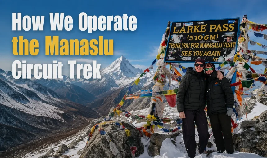
The summit of Larkya La Pass at 5,106 meters is marked with prayer flags. Many of them are old, faded by wind and sun over many seasons of crossings. When you reach the prayer flags, stop and stand there for a moment. Look north: the Tibetan plateau stretches away below and beyond the pass. Look east: Manaslu’s summit pyramid rises above everything, enormous and white and close. Look south and west: Himlung Himal (7,126 meters), Cheo Himal (6,820 meters), Kang Guru (6,981 meters), and in the far distance, the white line of the Annapurna range on the horizon.
This is the highest you have been in your life. Take the photograph. Celebrate with your guide. Then start down. The wind on the pass can develop quickly, and the descent to Bhimthang is long. Do not stay at the summit for more than fifteen or twenty minutes.
The Descent to Bhimthang
The descent from Larkya La to Bhimthang is steep, long, and physically demanding on the legs. The trail drops approximately 1,500 meters in elevation through rocky terrain, then through softer ground as altitude decreases, and eventually into the valley where Bhimthang sits surrounded by glaciers and forest.
The descent takes between four and six hours. In the early season (March and early April), the descent can include sections of snow and ice. The guide carries micro spikes or crampons for these conditions and advises when to put them on. Later in spring and in autumn, the descent is usually dry and rocky.
As you descend from the pass, the oxygen level rises gradually, and the physical sensation of your body working more easily with each meter of descent is palpable. By the time you reach the lower sections of the descent where vegetation begins to reappear, most trekkers feel a significant sense of relief and lightness. The hardest part of the circuit is behind you.
Arriving in Bhimthang
Bhimthang sits at 3,590 meters in a wide valley surrounded by some of the most dramatic glacial scenery of the entire trek. The valley floor is flat, dotted with mani walls and small stone shrines, glaciers flow from the surrounding peaks, and the last views of Manaslu’s summit are visible to the north. The vegetation has returned: juniper, pine, and open grassland with yaks grazing on the valley floor.
The teahouses in Bhimthang are more comfortable than those in Dharamsala. After the crossing day, the simple luxury of a proper bed, a bowl of hot soup, and a cup of tea in a warm room is immense. Most trekkers arrive in Bhimthang in the early to mid-afternoon, exhausted, hungry, and elated.
The guide takes your dinner and breakfast orders and then leaves you to rest. Eat well. Sleep long. The remaining days are all downhill from here.
Trek Day 10: Bhimthang to Tilche (2,300m)
Distance: approximately 16km | Walking time: 5 to 6 hours
After the crossing day, this is a recovery and descent day. The trail from Bhimthang descends through a dramatic change in landscape: from the open glacial basin above to dense rhododendron and pine forest below. The transition in vegetation and air quality over these kilometers is striking.
Leaving Bhimthang
The morning view from Bhimthang, on a clear day, is the last close-up of Mount Manaslu on the trek. The summit is visible to the north, above the Ponkar Himal ridgeline, framed by glaciers on either side. This is the farewell view.
The trail leaves Bhimthang heading south and descends into the forest. Within an hour of walking, the open alpine landscape of the upper circuit is replaced by dense rhododendron forest. In spring (March to April), these forests are in full bloom, with rhododendron trees covered in red, pink, white, and purple flowers. The transition from the stark, high-altitude world above Larkya La to the lush, forested descent below is one of the most dramatic landscape changes on any Nepal trekking route.
The Forest Descent and Gho Village
The trail descends through the forest past the small settlement of Gho, where a few teahouses serve lunch to passing trekkers. This is a typical lunch stop. The Marshyangdi River valley opens below as you descend and the sound of water becomes louder. The Dudh Khola, a tributary of the Marshyangdi, runs alongside the trail.
Arriving in Tilche
Tilche (also spelled Tilje) sits at approximately 2,300 meters in the Marshyangdi valley. After the remote, high-altitude world of the upper Nubri circuit, Tilche feels almost urban by comparison. It has a proper market street, comfortable teahouses with attached bathrooms, and the first mobile signal on this side of the mountains. The Marshyangdi river runs powerfully through the valley beside the village.
The evening in Tilche is a different social atmosphere than the teahouses higher on the circuit. The lower altitude, the warmer air, and the sense of completion that settles over a group after crossing Larkya La make for relaxed and celebratory dinners. The guide sits with you after dinner and explains the final section of the trek: the descent to Dharapani and the return drive to Kathmandu.
Trek Day 11: Tilche to Dharapani (1,963m) and Drive to Kathmandu
Trekking distance: approximately 8km | Walking time: 2 to 3 hours | Drive: 7 to 8 hours
This is the final day of walking and the long drive home.
Tilche to Dharapani
The morning walk from Tilche to Dharapani is gentle, following the Marshyangdi river valley southward through a landscape that becomes steadily more settled and agricultural. The trail passes through the villages of Goa and Thonje before reaching Dharapani.
Dharapani is the official endpoint of the Manaslu Conservation Area and the beginning of the Annapurna Circuit trail junction. It is a proper village with a checkpoint, several comfortable teahouses and restaurants, and regular jeep and bus services. The circuit is complete. From the Machhakhola police checkpoint, where your permits were first checked on Day 1, to the Dharapani checkpoint today, you have walked the entire Manaslu Circuit.
The Drive: Dharapani to Kathmandu via Besisahar
The return drive from Dharapani to Kathmandu is long: between seven and eight hours, depending on road conditions and how many stops are made. The route heads south through the Marshyangdi valley to Besisahar, the headquarters of Lamjung district, then east on the highway back toward Kathmandu via Dumre and Mugling.
The road from Dharapani to Besisahar is rough in sections, though improvements are ongoing. From Besisahar south, the road quality improves significantly, and the final hours of the drive are on a proper highway.
Arrange snacks and lunch for the drive before you leave Dharapani in the morning. There are roadside stops along the way but having food with you means you are not dependent on finding a stop at the right moment.
You arrive back in Kathmandu in the late afternoon or evening. Your guide or our team member accompanies you back to Thamel. The final night at the Moonlight Hotel feels very different from the first night you arrived.
The Final Evening in Kathmandu
The last evening is for rest and celebration in whatever combination suits you. Thamel has excellent restaurants at every price point. There are rooftop bars if you want to sit with a view of the city and reflect on what you just did. There are quiet coffee shops if you just want to sit down somewhere warm and comfortable.
The guide is available to help you find a good restaurant, assist with any shopping you want to do, and help arrange anything for your onward journey. If you need an airport transfer for a flight the following morning, let us know, and we will arrange it.
What Makes Our Operation Different
You have probably read other Manaslu Circuit Trek company websites that say similar things. Experienced guides. Quality service. Best price. It blurs together after a while.
Here is what is actually different about how we operate:
You talk to the guide from day one. When you message us, I answer personally. When you land at the airport, our team is there with your name on a sign. The guide who stands at your hotel door on departure morning is the same person who walked the briefing with you the night before and who crosses Larkya La Pass with you days later. There is no handoff from the office coordinator to a stranger.
No advance payment. Ever. You pay after you arrive, after you meet the team, after you feel comfortable. We have operated this way since we started. It is unusual in the Nepal trekking industry, and we are proud of it.
I grew up here. My family is from the Dhading district, the gateway district to the Manaslu region. This is not something I discovered by traveling to Nepal. It is where I come from. I have been walking the Budhi Gandaki valley since I was a child. That changes the way every trek is run.
We do not let you buy water you do not need. Free unfiltered water is available at every teahouse on the Manaslu circuit. We provide purification tablets and show you exactly how to use them. Buying bottled water on this trek is unnecessary and wasteful.
We come to you. Airport pickup. Guide and porter at your hotel door on day one. Payment collection at your hotel. You do not need to navigate to Kathmandu to find us. We find you.
Permits handled completely. We manage all three permits: the Manaslu RAP, the MCAP, and the ACAP. You do not need to understand the permit system, visit any government office, or think about paperwork at any stage of the trip.
Frequently Asked Questions
Do I need to pay before arriving in Nepal? No. Our policy is pay on arrival, no exceptions. You confirm dates, send your passport copy, and pay once you are in Kathmandu and have met the team in person.
How do I contact you after I land if I have a problem? WhatsApp at +977 9869225929 is the fastest way. Someone from our team monitors this number at all times when clients are arriving or on the trail.
What is the solo trekker rule? Since March 22, 2026, regulations require solo trekkers on the Manaslu Circuit to be accompanied by a licensed guide. This is a legal requirement. Solo trekking without a guide is not permitted and permits will not be issued. We include a licensed guide with every package.
Can I adjust the itinerary after I arrive? We discuss the full schedule in detail at the briefing, and if you want to add a rest day, adjust a stage, or modify the pace, we accommodate that wherever permitted and conditions allow.
What if I need to leave the trail early? Your guide knows every exit route from the circuit and handles emergency procedures for medical situations, severe weather, and personal emergencies. You are never left to manage this alone.
Do the teahouses in the upper circuit have hot showers? Hot showers are available in Machhakhola, Jagat, Deng, and Namrung as a standard facility. From Lho upward, solar-heated showers are available at most teahouses at an extra cost of approximately 200 to 300 Nepali rupees. At Dharamsala, basic cold-water washing facilities are all that is available. The guide advises at each stop.
What about attached bathrooms? Attached bathrooms are standard in most teahouses from Machhakhola to Samdo. The exception on the standard circuit is Deng, where some teahouses may have shared facilities. Dharamsala has only basic toilet facilities.
Can I charge my devices on the trail? Yes. Charging facilities are available at teahouses along the route from Machhakhola to Samagaun. The cost is approximately 200 to 500 Nepali rupees, depending on the device. Above Samagaun, solar power availability varies. Carry a power bank for the final days above 4,000 meters.
What about altitude sickness? Our guide is trained in wilderness first aid and in recognizing and responding to altitude sickness. The itinerary is designed with proper acclimatization built in. We follow strict protocols: if a client shows signs of serious altitude sickness, the guide initiates an immediate descent and contacts emergency services if required. We do not encourage anyone to push through genuine altitude sickness symptoms.
Is the Manaslu circuit safe for solo female trekkers? Yes. The Manaslu region is welcoming and respectful to all trekkers. Local communities along the circuit are accustomed to international visitors. Many solo female trekkers complete this circuit every year. The requirement to trek with a licensed guide actually adds a safety layer for solo travellers of any gender.
Do I need travel insurance? Yes, and it must include coverage for high-altitude trekking and helicopter evacuation. The guide advises on the minimum requirements at the briefing.
Ready to Start Planning?
If you are at the stage of researching Manaslu circuit trek companies and trying to figure out who to trust with this trip, I hope this guide has given you a real picture of exactly what we do and how we do it.
Send us a message on WhatsApp at +977 9869225929 or email us at info@manaslutreks.com. Tell me your travel dates, your group size, and your experience. I will reply personally, and we will start planning from there.
No advance payment. No middlemen. A local team from the Manaslu region has done this over 20 times and will do it properly for you.
Kiran Basnet is a licensed trekking guide (certified 2017) and founder of Manaslu Treks and Expedition, based in Thamel, Kathmandu. He has completed the Manaslu Circuit Trek over 20 times as a lead guide and grew up in the Dhading district, the gateway district to the Manaslu region. Manaslu Treks and Expedition is registered with the Government of Nepal and is a member of TAAN (Trekking Agencies’ Association of Nepal) and NMA (Nepal Mountaineering Association).

